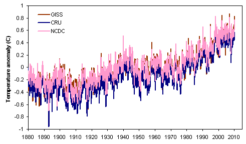
 Figure 1. Comparison of global (land & ocean) mean surface temperature reconstructions from NASA GISS, the University of East Anglia's CRU, and NOAA NCDC.
Guest post by Ned
There are three prominent reconstructions of monthly global mean surface temperature (GMST) from instrumental data (fig. 1): NASA's GISTEMP analysis, the CRUTEM analysis (from the University of East Anglia's Climatic Research Unit), and an analysis by NOAA's National Climatic Data Center (NCDC).
Figure 1. Comparison of global (land & ocean) mean surface temperature reconstructions from NASA GISS, the University of East Anglia's CRU, and NOAA NCDC.
How reliable are these temperature reconstructions? Various questions have been raised about both the data and the methods used to produce them. Now, thanks to the hard work of many people, we can conclude that the three global temperature analyses are reasonable, and the true surface temperature trend is unlikely to be substantially different from the picture drawn by NASA, CRU, and NOAA.
The three GMST analyses have much in common, though there are significant differences among them as well. All three have at their core the monthly temperature data from the Global Historical Climatology Network (GHCN), and all three produce both a land-stations-only reconstruction and a combined land/ocean reconstruction that includes sea surface temperature measurements.
Let's explore the reliability of these reconstructions, from several different angles.
Source code and data to recreate GISTEMP and CRUTEM are available from NASA and CRU websites. (The data set provided by CRU excludes a fraction of the data that were obtained from third parties, but the results are not substantially affected by this).
Both GISTEMP and CRUTEM have been successfully implemented by independent investigators. For example, Ron Broberg has run both the CRUTEM and GISTEMP code. In addition, the Clear Climate Code project has duplicated GISTEMP in Python. Figure 2 shows a comparison of the output of the GISTEMP reconstruction process as implemented by NASA and by Clear Climate Code ... but since the results are identical, the second line falls exactly on top of the first.

Figure 2. The GISTEMP land/ocean temperature analysis as implemented by NASA and by Clear Climate Code. Results of the two analyses are effectively identical.
Over the past year, there has been quite a flurry of "do-it-yourself" temperature reconstructions by independent analysts, using either land-only or combined land-ocean data. In addition to the previously-mentioned work by Ron Broberg and Clear Climate Code, these include the following:
(There are probably others as well that we're omitting!)
Most recently, the Muir Russell investigation in the UK was able to write their own software for global temperature analysis in a couple of days.
For all of these cases, the results are generally quite close to the "official" results from NASA GISS, CRU, and NOAA NCDC. Figure 3 shows a collection of seven land-only reconstructions, and Figure 4 shows five global (land-ocean) reconstructions.
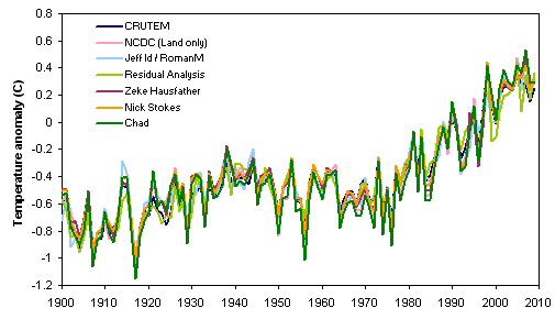
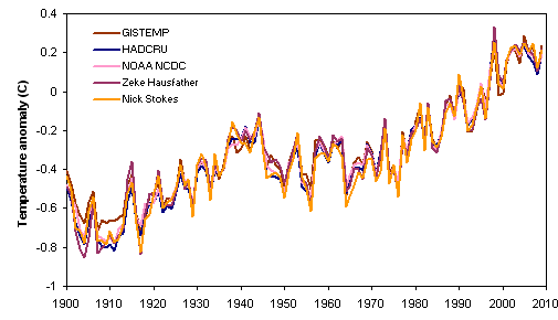
Obviously, the results of the reconstructions are quite similar, whether they're by the "Big Three" or by independent analysts.
Most of the analyses shown above actually use the raw (unadjusted) GHCN data. Zeke Hausfather has done comparisons using both the adjusted and raw versions of the GHCN data set, and as shown in fig. 5, the results are not substantially different at the global scale (though 2008 is a bit of an outlier).
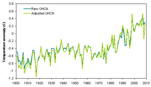
Figure 5. Comparison of global temperatures from raw and adjusted GHCN data, 1900-2009 (analysis by Zeke Hausfather).
While it is true that the number of stations in GHCN has decreased since the early 1990s, that has no real effect on the results of spatially weighted global temperature reconstructions. How do we know this?
* Comparisons of trends for stations that dropped out versus stations that persisted post-1990 show no difference in the two populations prior to the dropouts (see, e.g., here and here and here).
* The spatial weighting processes (e.g., gridding) used in these analyses makes them robust to the loss of stations. In fact, Nick Stokes has shown that it's possible to derive a global temperature reconstruction using just 61 stations worldwide (in this case, all the stations from GISTEMP that are classified as rural, have at least 90 years of data, and have data in 2010).
* Other data sets that don't suffer from GHCN's decline in station numbers show the same temperature increase (see below).
One prominent claim (by Joe D'Aleo and Anthony Watts) was that the loss of "cool" stations (at high altitudes, high latitudes, and rural areas) created a warming bias in the temperature trends. But Ron Broberg conclusively disproved this, by comparing trends after removing the categories of stations in question. D'Aleo and Watts are simply wrong.
This might seem like an odd statement, but some people have suggested that the tendency for weather stations to be located at airports has artificially inflated the temperature trend. Fortunately, there is not much difference in the temperature trend between airport and non-airport stations.
All of the above studies rely (mostly or entirely) on monthly station data from the GHCN database. But it turns out that other, independent data sets give very similar results.
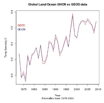
Figure 6. Comparison of global temperatures from the Global Historical Climatology Network (GHCN) and Global Summary of the Day (GSOD) databases. (Analysis by Ron Broberg and Nick Stokes).
What about satellite measurements of temperatures in the lower troposphere? There are two widely cited analyses of temperature trends from the MSU sensor on NOAA's polar orbiting earth observation satellites, one from Remote Sensing Systems (RSS) and one from the University of Alabama-Huntsville (UAH). These data only go back to 1979, but they do provide a good comparison to the surface temperature data over the past three decades. Figure 7 shows a comparison of land, ocean, and global temperature data from the surface reconstructions (averaging the multiple analyses shown in figs. 3 and 4) and from satellites (averaging the results from RSS and UAH):
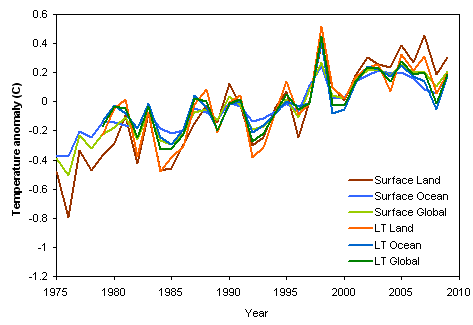
Figure 7. Comparison of temperatures from surface stations and satellite monitoring of the lower troposphere.
We'll end by looking at all the surface and satellite-based temperature trends over the entire period for which both are available (1979-present). What are the trends in the various data sets and regions? As shown in fig. 8, the surface temperature trends over land have a fair amount of variability, but all lie between +0.2 and +0.3 C/decade. Surface trends that include the oceans are more uniform.
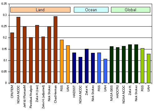
Figure 8. Comparison of temperature trends, in degrees C per decade.
Overall, the satellite measurements show lower trends than surface measurements. This is a bit of a puzzle, because climate models suggest that overall the lower troposphere should be warming about 1.2X faster than the surface (though over land there should be little difference, or the surface should be warming faster). Thus, there are at least three possibilities:
It should be noted that in the past the discrepancy between surface and satellite temperature trends was much larger. Correcting various errors in the processing of the satellite data has brought them into much closer agreement with the surface data.
The well-known and widely-cited reconstructions of global temperature, produced by NASA GISS, UEA CRU, and NOAA NCDC, are replicable.
Independent studies using different software, different methods, and different data sets yield very similar results.
The increase in temperatures since 1975 is a consistent feature of all reconstructions. This increase cannot be explained as an artifact of the adjustment process, the decrease in station numbers, or other non-climatological factors.
In contrast to normal practice here at Skeptical Science, for this post we have emphasized the "near-real-time" results of studies undertaken by individuals (in some cases non-specialists and highly talented amateurs) as published on blogs, rather than the work of professional scientists published in the peer reviewed literature. Since many of the "controversies" about the reliability of surface temperature trends first arose in the blogosphere, it is perhaps appropriate that those controversies are now being carefully and thoughtfully resolved in the same environment.
We would like to thank the scientists of GISS, CRU, and NCDC for their work and their patience. We would also like to thank the individual authors of the "independent" temperature analyses featured here, particularly Zeke Hausfather who compiled the results of multiple different reconstructions, and Lucia L. who provides space for Zeke's work on her blog.
Posted by Ned on Saturday, 24 July, 2010
 |
The Skeptical Science website by Skeptical Science is licensed under a Creative Commons Attribution 3.0 Unported License. |