Climate Science Glossary

Term Lookup

Enter a term in the search box to find its definition.

Settings

Use the controls in the far right panel to increase or decrease the number of terms automatically displayed (or to completely turn that feature off).

Term Lookup

Settings


All IPCC definitions taken from Climate Change 2007: The Physical Science Basis. Working Group I Contribution to the Fourth Assessment Report of the Intergovernmental Panel on Climate Change, Annex I, Glossary, pp. 941-954. Cambridge University Press.

Home Arguments Software Resources Comments The Consensus Project Translations About Support

Bluesky Facebook LinkedIn Mastodon MeWe

Twitter YouTube RSS Posts RSS Comments Email Subscribe


Climate's changed before
It's the sun
It's not bad
There is no consensus
It's cooling
Models are unreliable
Temp record is unreliable
Animals and plants can adapt
It hasn't warmed since 1998
Antarctica is gaining ice
View All Arguments...


Username
Password
New? Register here
Forgot your password?

Latest Posts

Archives

The Pacific Decadal Oscillation (PDO) is not causing global warming

What the science says...

Select a level... Basic Intermediate Advanced

The PDO shows no trend, and therefore the PDO is not responsible for the trend of global warming.

Climate Myth...

It's Pacific Decadal Oscillation

"The Pacific Decadal Oscillation (PDO) is a temperature pattern in the Pacific Ocean that spends roughly 20-30 years in the cool phase or the warm phase. In 1905, PDO switched to a warm phase. In 1946, PDO switched to a cool phase. In 1977, PDO switched to a warm phase. In 1998, PDO showed a few cool years. Note that the cool phases seem to coincide with the periods of cooling (1946-1977) and the warm phases seem to coincide with periods of warming (1905-1946, 1977-1998)." (The Reference Frame)

At a glance

Oscillate. To move repeatedly from side to side or up and down between two points, or to vary between two states or amounts. To vary above and below a mean value. To move or travel back and forth between two points. To swing backward and forward like a pendulum.

These and similar definitions are to be found if you look up the meaning of 'oscillate' online. Yet global warming is wobbling its way up a one-way course. We've just witnessed the hottest year since temperature records began (2023). Every few years that record goes again. Conclusion: global warming is not an oscillation.

The Pacific Decadal Oscillation or PDO is one of a number of phenomena that affect the world's major oceanic basins. It is a good example of heat being moved around within the ocean and atmosphere. Like all climatic oscillations it has warm, neutral and cool modes and these may endure for years or decades. Oscillations like this do not correspond to a timetable, but are irregular in nature.

The PDO is directly driven by conditions in the northern Pacific but has considerable reach in its effects. Prevailing winds and atmospheric pressure-patterns over that ocean dictate the mode. When winds are predominantly from the southwest, warmer conditions occur along the western USA seaboard. That is due to the onshore transport of warm, subtropical waters. Conversely, when winds are mainly from the north, upwelling of cool and nutrient-rich waters occurs in the open ocean, with cooler conditions prevailing.

Notable long, warm modes of the PDO include 1925-1946 and 1977-1998. 1947-1976 was a lengthy cool phase. More recently, the flip-flopping has been of a much shorter duration with cold and warm phases lasting just a few years. The reason for this switch is incompletely understood.

Like the El Nino Southern Oscillation or ENSO, which flips around over annual timescales, the PDO affects weather patterns, particularly in Asia and North America. It also has considerable impacts on fisheries and if there was one good reason to understand the PDO, it's right there. However, despite the loose coincidence with global temperatures in the early and mid-20th Century, that apparent relationship is no more. For example, a negative PDO mode commenced at the end of 2019 and was still ongoing in mid-2023, the latter having been the warmest year globally since records began.

Like all oscillations, there is no net gain or loss of heat involved in the PDO. It is merely a pattern involving how the heat in the system is being moved around within it. Global warming is different because it involves impeding the loss of heat, originally reaching the planet as sunshine, back out to space. That makes it a climate forcing agent. Big difference.

Oscillate. It's all in the name.

Please use this form to provide feedback about this new "At a glance" section. Read a more technical version below or dig deeper via the tabs above!


Further details

The Pacific Decadal Oscillation (PDO) is a climate phenomenon that occurs primarily in the North Pacific Ocean. It has wide ranging effects on weather patterns, especially over North America and Asia. Like other ocean-basin oscillations, it has a warm mode, expressed as positive values in the PDO index, and a cool mode, with negative values. These modes last anywhere from a few years to multiple decades and feature changes in sea surface temperatures.

While the causes of the PDO are still poorly understood, the primary effects seem to be changes in northeast Pacific marine ecosystems and therefore fisheries. Also they affect the position of the jet stream's path, that may in turn impact agriculture.

During the PDO positive mode, winters in the southern and eastern US states tend to have above average temperatures and higher rainfall. In the western and north-western states, the opposite is the case. Asian winters tend to be cooler and dryer, although above normal temperatures and higher rainfall tend to occur over India.

In the negative PDO mode, warmer and drier winters occur through much of the contiguous USA, with cool conditions confined to the north-west, although parts of the central USA may see notably wet conditions. Over in Asia, India and China see relatively cool and wet winters, whilst Japan has both the warmth and the rainfall. Clearly, a key impact of the PDO is on agriculture, hence its extensive study and the substantial scientific literature surrounding it.

It is important to note, however, that the PDO modes are not set in stone. Frequently, especially in recent years, short sets of 1-5 warm years have occurred during a cool phase and vice-versa. In addition, the warm and cool modes are less descriptive than they would appear. The cool mode, for instance, is in fact associated with high sea surface temperatures in the Northern Pacific (Fig. 1). Another important point is that the hottest year in the global temperature record, 2023, has occurred within a negative PDO mode.

Example of the PDO warm mode.Example of the PDO cool mode.

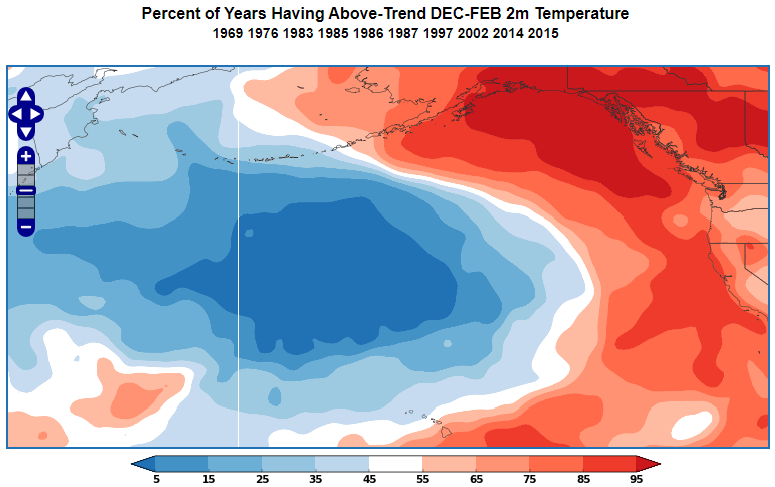
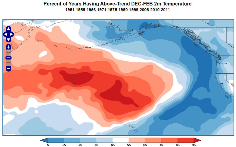
Figure 1: Examples of the PDO warm mode (above) and cool mode (below). During the positive PDO mode, sea surface temperature anomalies over the North Pacific Ocean form a vast cool area north of Hawaii. At the same time, warmer than normal waters are present near the North American coast. During negative PDO conditions, warm waters are found north of Hawaii and cooler than normal waters are encountered near the North American coast. Images courtesy of World Climate Service.

Because the PDO is an oscillation, it does not present a clear trend. If you compare the Global Temperature Anomaly alongside the PDO Index (fig. 2), you will see that although the PDO index appears to influence short-term temperature changes, global temperatures have had a distinct upward trend, especially since the late 1970s.

 Global temperature anomaly 1850-2023.

PDO time series.

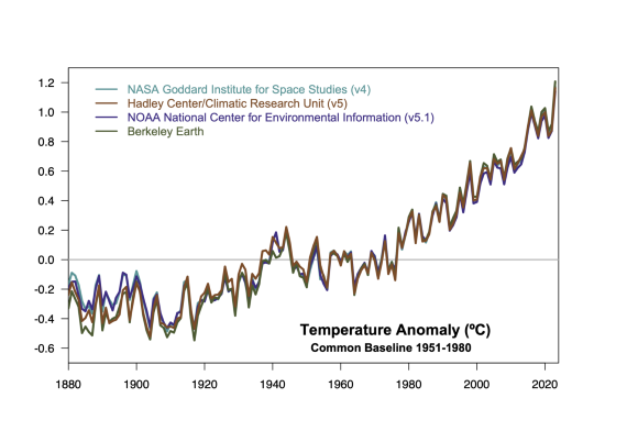
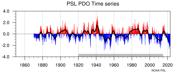
Figure 2: Top-panel: global temperature anomaly 1850-2023. Graphic: Realclimate. Bottom-panel: Pacific Decadal Oscillation index, 1870-2023. Smoothed data (thicker black line) included. Graphic: NOAA.

Natural oscillations like the PDO simply move heat around from oceans to air and vice-versa. They don't have the ability to either add or remove heat to or from the overall system. Therefore, they're not capable of causing a long-term warming trend like that of the last 50+ years. Instead they are another example of a process causing short- to medium-term temperature variations. Basically they're good examples of internal climate variability. If the PDO was responsible for warming the surface, the oceans would be cooling, which is not the case.

The long term warming trend on Earth is due to increasing greenhouse gas levels. These constitute an external radiative forcing, creating an energy imbalance. In contrast, the PDO is an internal process and does not increase or decrease the total energy in the climate system. Essentially, like other such oscillations, it cancels itself out. The fact that its name defines it as an oscillation should communicate that fact.

Last updated on 31 March 2024 by John Mason. View Archives

Printable Version  |  Offline PDF Version  |  Link to this page

Argument Feedback

Please use this form to let us know about suggested updates to this rebuttal.

Acknowledgements

Many thanks to John Cross who co-authored this post. Thanks also to Josh Willis for his advice on this topic.

Comments

Prev  1  2  3  4  5  6  Next

Comments 51 to 75 out of 130:

  1. @thepoodlebites: "Based on the evidence, I don't think that we know for sure either way but pre-cursor indicators suggest that we may be headed into another period of cooling similar to the 60's and 70's." Actually, there is no evidence showing we are about to enter a period of cooling (nor was the 70s a period of cooling either "When I took advanced meteorology classes in 1981 the consensus was that we may be entering into another ice-age." Please provide evidence that global cooling was the scientific consensus in 1981, because AFAIK that's not true. "I visited the Holocaust Museum in Washington, DC. To label a skeptical scientist a denier is insulting." "Denier" is not attached to the Holocaust, "Holocaust denier" is. Someone who deniers the theory of evolution is an "evolution denier," and someone who denies AGW theory is a "climate change denier." Don't wrap yourself in the mantle of indignant victimhood over this, it's kinda disrespectful for the actual Holocaust victims. "Stick to the scientific method, stay objective, don't give in to personal bias, that leads to the dark side." Sticking to the scientific method will lead you to acceptance of AGW theory. It's not a question of bias, but of evidence - believe me, I'd much rather AGW be false! As far as UAH vs. GISS goes, why not use both? In fact, why not use all the data: Hadcrut, GISS, UAH and RSS? They may not all show the same temperature exactly, but they all show the same trend, and that's what counts.
  2. #50: "I'll keep referring to the UAH plot... " Perhaps you should also refer to Assessing global surface temperature reconstructions, which demonstrates that all temperature measures are very similar. Figure 8 in that post renders PDO and even Nino/Nina influences on the long term trends a moot point. "I hope we agree that the plot presented in post #39 is misleading." No, we don't agree.
  3. Recap: Warming trend: PDO+AMO shows stronger correlation than CO2, R^2 for CO2 = 0.44 R^2 for PDO+AMO = 0.85 where (R^2 is the coefficient of determination) A new article in the International Journal of Geosciences Warming Power of CO2 and H2O: Correlations with Temperature Changes, supports the idea of the weak correlation between CO2 and global warming, natural cyclical processes show stronger correlation in the surface record. Conclusions: "CO2 has not a causal relation with global warming and it is not powerful enough to cause the historical changes in temperature that were observed."
  4. #53: "natural cyclical processes show stronger correlation in the surface record." So you are claiming that correlation requires causality? Did you run that past the denial establishment to see if they reached a consensus on that? What causes the PDO/AMO?
  5. #53. The International Journal of Geosciences is perhaps not quite what it seems Mind you I'm looking forward to the first articles from this prestigious sounding tome
  6. PDO as an oscillation between positive and negative values shows no long term trend, while temperature shows a long term warming trend. When the PDO last switched to a cool phase, global temperatures were about 0.4C cooler than currently. The long term warming trend indicates the total energy in the Earth's climate system is increasing due to an energy imbalance. OK, so the global temp has been flopping around in a 2-3 C range for the last 10K years. Do we have all the reasons for these "energy imbalances"?
  7. Yes, to posit otherwise requires explaining why the current understanding coincidently adds up. Please read argument #2.
  8. Muoncounter, see my comment #13 on what seems to cause PDO. So far, again, and unfortunately I have not seen one single other viable explanation on this blog. As I also mentioned, a sinus (or co-sinus) wave oscillates perfectly around 0 too, and the trend line through one complete wave length is of course 0. But that doesn't mean there are no "trends" in a sinus wave pattern, which there obviously are depending on where you (x) are in the wave. Bakes the question, where are we (temperature wise) on such a sinus wave, and is there a temperature sinus wave? History has shown time and again temperatures go up and down... Anyway, I have to say that the 2nd graph in this post is misleading. One can't simply draw a straight line through the temperature record and the PDO. That's BS (bad science). Why? Simply because there are seasonal cycles in the temperatures and those need to be adjusted for first. Likewise with the PDO, which oscillates (sinus wave like pattern); see prior paragraph and my comment under #25. After the seasonal adjustment is done, THEN a linear regression may be done through the entire data set. But, in this case we can't do that either as there are clearly years where trend-reversals occur (see comment #25). Hence, drawing a straight-line through the entire seasonally-adjusted data-set is also BS. Since regression lines are in fact models, we need to find the model that best fits the (temperature) data, expressed as r2. In excel, a simple linear regression line through the seasonally adjusted data from 1900 to 2010 would give an r2 of ~0.68. A polynomial to the sixth (excel's limit) order gives an r2 of .81. Hence the data is better explained with a 6th order regression line. (of course with an even higher order it would explain up to an r2 of 1, but that's not the issue here; it's the fact that the increase has not been linear) Back to the PDO and temperature; I don't think PDO can explain most/much of the observed temperature trend; only to a certain degree. But, instead, and as pointed out under comment #13, I think the PDO can explain the ENSO/NOI cycle much better.
  9. Re: Strength of current La Nina (from other thread). There seem to be conflicting measurements. The one I and others posted was this table: http://www.cpc.ncep.noaa.gov/products/analysis_monitoring/ensostuff/ensoyears.shtml But the chart on this page http://www.esrl.noaa.gov/psd/people/klaus.wolter/MEI/ shows it historically strong. Apparantly the table is ONI, measured by SST differences only whereas the latter graph is MEI (M for Multivariate) taking into account more variables. IMO the MEI would be a better indication of La Nina effects, so I would call it strong (strongest since the mid 70's). We also will have to wait and see about the duration, it hasn't been around long.
  10. Indeed; however, MEI is a ranking system not a value or measurement in it self, such as a SST for example. MEI looks at "all" effects of la ninas and el ninos, combines those and ranks the outcome: six main observed variables over the tropical Pacific, some of which not related or only indirectly related to temperature: e.g. sea-level pressure, zonal and meridional components of the surface wind, and total cloudiness fraction of the sky. ONI is a SST. In addition, MEI is bi-monthly, ONI tri-monthly. Hence the fact that some bi-monhtly MEI rankings are high doesn't necessarily mean it is also the coldest (lowest SST) la nina, which it obviously is not according to NOI. We indeed need to wait and see how the current la nina develops; in December SSTs crept up a bid, but have decreased again somewhat in January. The most recent pattern of SST anomalies is similar to that observed since mid November 2010. I'd expect the NDJ season somewhere between -1.3 and -1.6 at the most. Note that global temperatures lack often 3-6 months in response to ENSO events.
  11. #54 Correlation is a necessary but not sufficient condition for causality. If you find strong correlation you should investigate to establish a possible relationship. WhatDoWeKnow is correct, the Sun can not respond to changes in the Earth’s oceans or atmosphere, that would be silly. But there is evidence that the oceans respond to changes in the Sun and the atmosphere responds to changes in the ocean. I see the PDO and other cyclical ocean processes (AO, NAO, AMO, ENSO) as heat redistribution systems. Upwelling brings colder water to the surface. And we know that deep water is very cold. El Nino begins when the trade winds weaken, allowing warm water to flow from the western pacific to the eastern pacific. Kelvin waves develop that reflect and propagate both North and South along the North/South American coasts. Even longer term Rossby waves can propagate westward at higher latitudes back towards Japan. I know that there is debate about the relationship between ENSO and PDO but I think they are connected. I see ENSO and the PDO as a transfer of heat from the tropics to higher latitudes. It’s like two steam generators that are connected through a secondary system. The relationship is dynamic, nonlinear and inherently oscillatory. Currently, with the cool phase of the PDO and La Nina working together, we are seeing a cooling response in the atmosphere. I’m expecting to see the UAH globally averaged satellite-based temperature anomaly for Jan. 2011 to be near or below zero, similar to the beginning of 2009. That would effectively wipe out 30+ years of warming in the satellite record. And the Sun is still unusually quiet. That’s my take, have fun tearing it apart.
  12. thepoodlebites, my prediction is that if "30+ years of warming in the satellite record" is wiped out, then we will also see a significant rise in OHC.
  13. thepoodlebites wrote : "I’m expecting to see the UAH globally averaged satellite-based temperature anomaly for Jan. 2011 to be near or below zero, similar to the beginning of 2009. That would effectively wipe out 30+ years of warming in the satellite record. And the Sun is still unusually quiet." So, you're saying that the anomaly you are predicting for Jan 2011 ("near or below zero") will be similar to the "beginning of 2009" (is that Jan 2009 or some/a few/several months ?) - the year before 2010, which UAH list as the 2nd warmest in their records, i.e. warmer than 2009 - and that this will subsequently "wipe out" the UAH positive trend of roughly 0.4C seen over the last 30 years ?
  14. #61. I agree, except with the "wipe out part". Anyway, back to PDO and ENSO and how they relate. Among other aspects of the ENSO and PDO cycle, I wrote this in one of my earlier comments (#13): "Adding PDO events (warm to cold reversals, vice versa, phase shifts, etc) to the NOI data we instantly see the following: The 2008 la nina coincides exactly with the PDO GPTC The 1998 el nino coincides exactly with the PDO phase shift from warm to cold The 1988 la nina coincides exactly with the highest PDO (LPTC) since 1934 The 1977/78 el nino coincides exactly with PDO phase shift cold to warm The 68/69 la nina coincides exactly with PDO's phase reversal The 55/56 la nina coincides exactly with the lowest PDO value since 1900 In addition, between 1950 and 1977 there were 126 la nina seasons (months) and 75 el nino seasons: PDO was cold Between 1977 and 1998 there were 53 el nino seasons and 27 la nina seasons: PDO was warm." Do we really need much more proof too see that ENSO and PDO are related?
  15. #64: "Do we really need much more proof " Your examples hardly prove anything. In one case el Nino coincides with a warm to cold PDO shift, in another, it coincides with cold to warm. In one case la Nina coincides with highest PDO, in another it coincides with lowest PDO. Is that supposed to be causal?
  16. #63 Sorry, typo, Jan. 2008, not 2009, See UAH. Notice the dip below -0.2 C.
  17. thepoodlebites wrote : "Jan. 2008, not 2009, See UAH. Notice the dip below -0.2 C." Let me try again then : So, you're saying that the anomaly you are predicting for Jan 2011 ("near or below zero") will be similar to that for "Jan. 2008...below -0.2 C" - a couple of years before 2010, which UAH list as the 2nd warmest in their records, i.e. warmer than 2008 - and that this will subsequently "wipe out" the UAH positive trend of roughly 0.4C seen over the last 30 years ? I still can't see it so maybe you should show how you work that out ?
  18. #65 muoncounter; In '68 there was a PHASE REVERSAL, meaning tops become bottoms and vice versa; prior '68 GPTCs were tops and are bottoms post '68 whereas prior '69 LPTCs were bottoms and are tops post '68. Hence, why ENSO events related to tops and/or bottoms depending on if they occurred pre- post '68. The fact then that ENSO events coincide EXACTLY with key PDO events thus proofs they are related. I suggest learning more about the PDO (and probably ENSO cycle too) so you better understand the intricacies of natural cycles, how they inter connect and how they play a role on climate.
  19. #68: "tops become bottoms and vice versa" Ah-ha. That's much clearer now. We heard this way back here. For those who might not know, GPTC is "greatest perturbation in the torque cycle," a concept based on solar angular momentum from the writings of Theodor Landscheidt, "author, astrologer and amateur climatologist". Disciples of Landscheidt have us already in a new ice age. There is a host of interesting stuff there: Over the past several million years the planet has spent around 80% of its time under ice. ... The outer planets over long periods influence the shape of the earth’s orbit via gravitation perturbations. ... changing the way heat is received from the Sun which leads to a gradual build up of snow/ice that does not melt during summer in the northern hemisphere. ... The two oscillations combining to achieve the largest amplitude of modulation for over a hundred years that also corresponds to the large temperature increase between 1970 and 2000. The IPCC determines this as an AGW forcing but perhaps they have been riding a wave driven by celestial forces that is now crashing down around them? What can be said that is large enough for all this?
  20. #67 Let's say (for the sake of argument) that the Jan. 2011 UAH anomaly is -0.2 C, a good possibility. The Dec. 2010 UAH anomaly was +0.18 C, a fact that is not in dispute, I hope. From the plot we can see that the monthly anomaly would then be back down to near Jan. 2008 (-0.3 C). Actually, that would bring us all the way back to near the beginning of the satellite record, June 1979 (-0.2 C). And remember, the peaks in 1998 and 2010 were from El Nino warming. The latest SST's still show La Nina. These are monthly means, whether the 12-month running mean drops to near zero will be determined in the coming months. Continued warming would mean higher highs and higher lows. Yeah, I'd say it's a wipe-out, just like in 2008.
  21. This just in, Jan. 2011 UAH, -0.01 C.
  22. thepoodlebites - I saw that item about the UAH January temperature. It hasn't shown such a monthly low since, lets see, 2009, much of 2008, 2006, 2005, or 2001. All part of the warmest decade on record. Are you trying to make a climate related point from a single month's data? You haven't indicated in your post as to why you consider that datum important. It has been said time and again, by lots and lots of people - you cannot make a climate estimate (~30 year trend) from short term (in this case, one month) data. There's too much short term variation to consider trend extraction from the short data set; you're talking about roughly 1/360th the data needed.
  23. Worth noting too, that everything we know about climate says that UAH will plummet this year (La Nina) and it will go down further than land record. However if you want to know about climate rather than weather then please compare UAH now with UAH in past periods which have La Nina index of the same magnitude. If it comes to that, compare the minimum temperature of the coming La Nina cycle with the MAXIMUM of El Nino temperature 30 or 40 years ago. Want to guess what UAH will show in the next El Nino of 1.8 or more?
  24. #73 Feb. 2011 UAH, -0.02, not as low as I thought. It will be interesting to see how 2011 pans out. The PDO is still negative and La Nina is hanging in there. I don't follow what you are predicting for this La Nina, Nino 3.4. Some La Nina cycles last longer than others but there is no clear trend that I can see. Before 1980, we had no El Nino's >+1.8 C between 1950 - 1971, note: during negative phase of the PDO, then 1972 (+2.1), 1983 (+2.3), 1998 (+2.5), 2009 (+1.8). And La Nina's, 1955 (-2.0), 1973 (-2.1), 1984 (-1.1), 1988 (-1.9), 1999 (-1.4), 2010 (-1.4).
    Response: [DB] Tamino has a post for those who see meaning in cycles where statistical significance tests show none here.
  25. thepoodlebites at 07:40 AM, FYI, the latest JAMSTEC, SINTEX-F1 CGCM forecast(27-member ensemble) (updated February 15, 2011) ENSO forecast: The current strong La Nina condition would decay in following boreal spring and summer seasons but would rebound in fall and persist up to early 2012. The revived one would show a La Nina of Modoki nature. IO forecast: Associated with the La Nina impact, the surface temperature in the equatorial Indian Ocean has become colder than normal in January 2011. The tropical Indian Ocean surface temperature would decrease further in following seasons but with strong warming along the west coast of Australia. In the second half of 2011, a weak negative IOD might tend to occur. Regional forecast: Associated with the La Nina influence, below-normal surface air temperature and above-normal precipitation would continue in Australia, northern Brazil, and southern Africa during the austral fall-winter. Southeastern China,southwestern Japan, US and Europe would have warmer-than-normal and dry climate during spring-summer seasons. According to data from the Queensland Natural Resources and Mines, La-Nina conditions that extended over multiple year occurred in 1892-93, 1916-17, 1955-56, 1970-72 and 1973-74-75. El-Ninos that extended over multiple years occurred in 1913-1914, 1918-1919, 1940-41,and 1991-92-93-94. Note, to avoid confusion, given the NR&M classify the years as from April to March, the beginning years are as indicated, but the ending years are at the end of March in the year following that indicated above.

Prev  1  2  3  4  5  6  Next

Post a Comment

Political, off-topic or ad hominem comments will be deleted. Comments Policy...

You need to be logged in to post a comment. Login via the left margin or if you're new, register here.

Link to this page


The Consensus Project Website

THE ESCALATOR

(free to republish)


© Copyright 2024 John Cook
Home | Translations | About Us | Privacy | Contact Us