
A new paper published in Science by Fasullo and Trenberth of the National Center for Atmospheric Research (FT12) takes an interesting approach to determine which climate models best simulate changes in cloud cover. Equilibrium climate sensitivity (ECS) is defined as the total global surface warming that will occur as a result of a doubling of atmospheric CO2 once the planet reaches a new energy equilibrium. On Earth it can take several centuries to reach a new energy equilibrium because of the slow response of the oceans.
The value for ECS obtained from global climate models varies by approximately a factor of two, with the ECS of models used in the 2007 IPCC report ranging from 2.1 to 4.4°C for doubled CO2. This model sensitivity range is an emergent property of the models themselves, and arises due to the different approximations of physical processes which are built into each model. However, this senstivity range has not changed significantly over the past two decades, despite climate models undergoing constant revisions.
It's important to note here that the full body of scientific evidence with regards to climate sensitivity - not just from models, but also from past climate changes thousands, tens of thousands, and even millions of years ago paints a very consistent picture that ECS falls somewhere in this range of about 2 to 4.5°C average global surface warming in response to an energy imbalance equivalent to that caused by a doubling of atmospheric CO2 (Figure 1).
Figure 1: Distributions and ranges for climate sensitivity from different lines of evidence. The circle indicates the most likely value. The thin colored bars indicate very likely value (more than 90% probability). The thicker colored bars indicate likely values (more than 66% probability). Dashed lines indicate no robust constraint on an upper bound. The IPCC likely range (2 to 4.5°C) and most likely value (3°C) are indicated by the vertical grey bar and black line, respectively. Adapted from Knutti and Hegerl (2008).
Clouds and the feedback they exert by changing the Earth's reflectivity (albedo) are one of the primary factors in determining ECS, but the magnitude of the cloud feedback remains a fairly large uncertainty. In fact, when climate contrarians like Richard Lindzen argue that climate sensitivity is low, they most frequently do so by arguing that clouds provide a large negative feedback, in which case they would offset much of the increased greenhouse effect and thus dampen future global warming. Similarly, Spencer and Braswell (2011) treated clouds as an 'internal forcing' which they believe effectively behaves as a negative feedback. However, Trenberth, Fasullo, and Abraham (2011) identified a number of problems in the Spencer and Braswell paper which render its conclusions incorrect and unsupportable.
Indeed as FT12 note, there is a growing body of evidence that in reality clouds act as a modest positive feedback, slightly amplifying global warming. This is also consistent with most model simulations of the cloud feedback, but there remains a fairly wide spread in the possible value of this feedback. Unfortunately, as FT12 discuss, the currently available observational cloud data are not very good.
"Constraining simulated clouds is a challenge, however, as clouds are complex and difficult to observe. The historical record is plagued by errors associated with the drift and failure of satellites, inconsistencies in the detection of clouds, and instrument biases. Moreover, clouds can vary not just in their bulk characteristics but also in their microphysical properties, for which global observations are lacking generally, and considerable uncertainty persists regarding the feedbacks of various cloud types that may occur in a changing climate."
Thus rather than examining clouds directly, FT12 take a different approach and instead look at the conditions in which clouds form.
"Variations in clouds and relative humidity (RH) are inherently linked in nature, and the approach here is motivated by the fact that models generally use RH to parameterize clouds"
In a somewhat similar fashion to Spencer and Braswell (2011), FT12 compare simulations from multiple global climate models to satellite observational data, and draw conclusions about climate sensitivity based upon model correlation to the real world. However, FT12 show the results of all model runs, whereas Spencer and Braswell omitted the results of models with intermediate ECS, among other problems with their methodology.
FT12 use satellite data from the NASA Atmospheric Infrared Sounder (AIRS) and Clouds and the Earth's Radiant Energy System (CERES) to examine the relationship between seasonal changes in relative humidity (RH) in the dry subtropics and the Earth's albedo via cloud cover. Karen Shell describes the process in a Science Perspective.
"In boreal summer, the location of maximum solar heating moves north, resulting in air ?ow across the equator. Warm, moist air rises, loses water through rain, moves north or south, and descends in the high-pressure subtropical zones as relatively dry air. The decreased RH makes condensation, and hence cloud formation, less likely. More sunlight is absorbed, leading to warming."
In particular, FT12 note that in the atmospheric layer at which the pressure is about 500 hectoPascals (hPa), there is a strong relationship between RH and clouds. This is illustrated in Figure 2, which shows distinct broad atmospheric dry zones in the subtropics around 500 hPa in blue, compared to where climate models expect them to broaden in a warmer climate (dashed lines, with poleward broadening depicted by the two black arrows).
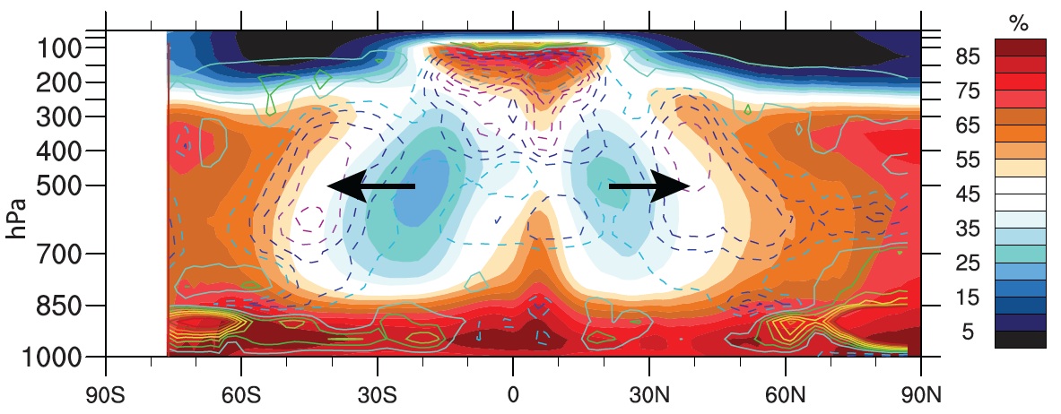
Figure 2: The zonal height structure over ocean of observed climatological annual mean RH from AIRS (2002–2007) (color scale), with model mean projected changes in cloud amount from the CMIP3 model archive (contour lines, 0.5% intervals, dashed for cloud loss). The cloud loss in a warming climate at about 40°N/S coincides with broadening of the dry zones, as indicated by the arrows. Figure 2 from FT12.
FT12 then examine the correlation between ECS and model simulations of RH over all latitudes during a warming 21st Century. In Figure 3, the latitudes at which the change in flux of infrared radiation at the top of the atmosphere is strongly correlated to ECS are depicted in red, including at subtropical latitudes.
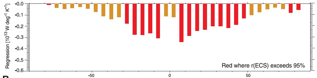
Figure 3: Median change in simulated top-of-atmosphere net shortwave flux as a function of latitude under 21st-century warming in CMIP3 SRES A1B projections. Red bars denote latitudes at which the change in net shortwave flux correlates with ECS at the 5% confidence limit. Figure 3a from FT12.
A similar correlation can also be seen in present-day simulations in Figure 4, which shows the correlation between simulated May-August RH and model ECS for the period of 1980 to 1999. The dark blue and dark red regions show the strongest negative and positive correlations, respectively, between RH and ECS. The peak correlations are labeled in the dry (D) and moist (M) zones.
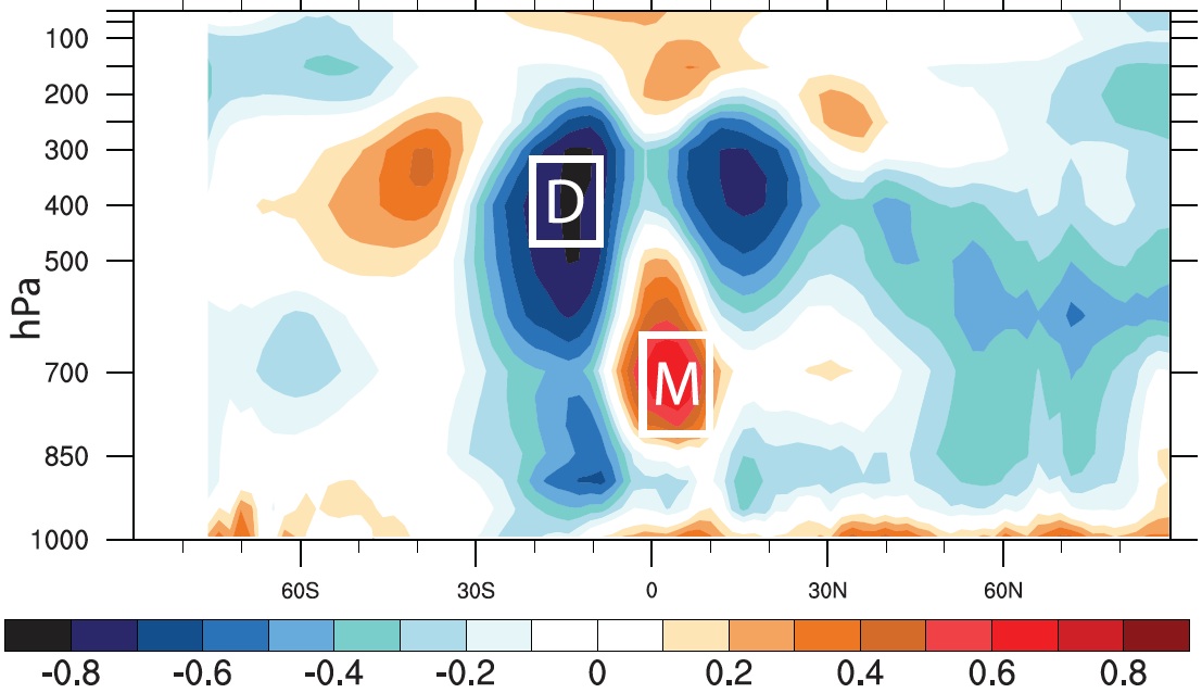
Figure 4: Zonal mean vertical structure of the correlation between present-day (1980–1999) simulated RH over ocean from May to August in CMIP3 models and ECS. Boxed regions highlight peak positive and negative correlations in the moist (M) and dry (D) zones, respectively, where the statistical significance of the relationships exceeds the 1% confidence limit. Figure 3b from FT12.
FT12 note that "The correlations with RH are not only statistically significant but of sufficient magnitude to explain a considerable fraction of the variance in ECS across models." They then examine the moist and dry regions in Figure 4 with the strongest correlations between RH and ECS to determine which models (and which ECS values) most accurately simulate the RH in those moist and dry zones (Figure 5).
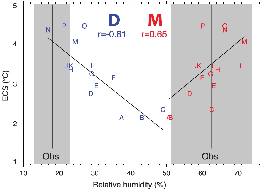
Figure 5: Scatterplot of present-day simulated zonal mean RH over ocean from May to August in the dry (D) and moist (M) zones (Fig. 3) versus ECS. Mean observed values (vertical black lines) and their range (gray) are based on values from AIRS retrievals and the MERRA and ERA Interim reanalyses. Letters denote individual model runs from coupled 20th century runs. The correlations with ECS for each region are shown and indicated by the least-squares regression line. Observations and model values are based on climatologies from 1980 to 1999, except for AIRS, which is based on 2002–2007 data. Figure 4 from FT12.
The range of RH uncertainty (the gray areas in Figure 5) is smaller for the dry region than the moist. While the climate model RH simulations all fall within the range of observed values in the moist region, many of the models - specifically those with lower ECS - fall well outside of the range of observed RH values in the dry region. From this, FT12 conclude as follows.
"These results suggest a systematic deficiency in the drying effect of either subsident circulations or spurious mixing of moister air into the region in low-sensitivity models that directly relate to their projected changes in cloud amount and albedo. Although the lower-sensitivity models are clearly at odds with observations, extrapolating the consequences of these model biases to climate sensitivity is nontrivial"
"...the results strongly suggest that the more sensitive models perform better, and indeed the less sensitive models are not adequate in replicating vital aspects of today’s climate. The correct simulation of the vertical structure of RH and clouds should be a prerequisite for developing confidence in projections for the future."
In short, while FT12 does not provide a specific measurement of climate sensitivity, it does suggest that the climate models with lower sensitivity (and 'low' here refers to approximately 2 to 3°C surface warming in response to doubled CO2, not the ridiculously low estimates of 1°C or less proposed by contrarians like Lindzen) are not accurately representing changes in cloud cover, and are therefore biased. Climate models with higher sensitivity - in the 3 to 4.4°C ECS range for doubled CO2 - more accurately simulate the observational RH data and thus the response of subtropical clouds to climate change.
A climate sensitivity on the higher end of the likely range obviously does not bode well for the future of the climate. As Fasullo told The Guardian, "our findings indicate that warming is likely to be on the high side of current projections."
In terms of warming over the 21st Century, we are currently on track with IPCC emissions scenario A2, which corresponds to about 4°C warming above pre-industrial levels by 2100 if ECS is around 3°C for doubled CO2. Note that's the warming models expect by the year 2100, but at that point there will still be a global energy imbalance, and thus additional warming will remain 'in the pipeline' until the planet reaches a new equilibrium. An even higher ECS would correspond to even more warming, but anything greater than 4°C would almost certainly be catastrophic.
FT12 adds to the body of scientific evidence that we need to take serious action to reduce greenhouse gas emissions as soon as possible. We still have time to change course and avoid climate catastrophe, but the evidence is building that time is running out fast.
Posted by dana1981 on Tuesday, 13 November, 2012
 |
The Skeptical Science website by Skeptical Science is licensed under a Creative Commons Attribution 3.0 Unported License. |