
Guest post by muoncounter
How there can still be honest disagreement over whether a large body of ice is shrinking or increasing in areal extent over the long term is really quite remarkable. Since the reports don’t seem sufficiently convincing, let’s look at the question analytically. In the NOAA’s October, 2009 update to the Sea Ice Cover section of the “Arctic Report Card,” Figure S2 (reproduced below) shows the percentage change in the annual minimum (September) and maximum (March).
This graph is presented as percentage difference in ice extent (area in millions of sq km), relative to the mean for the period (1979-2009). Both the maximum and minimum are shown with a linear fit; by the slopes of these lines, we see that the sea ice minimum is decreasing faster than the sea ice maximum. Hence we expect the discrepancy between min and max to increase.
This change in areal extent is accompanied by a systematic change in ice thickness, resulting in an overall decrease in ice volume, as demonstrated in NOAA’s Figure S4 below.

The text accompanying this figure draws a distinction between “multi-year” ice and “first-year” ice, noting that it is the multi-year ice that is thinning. NOAA’s conclusion is self-evident: “These changes have resulted in seasonal ice becoming the dominant Arctic sea ice type, both in terms of area coverage and of volume” (Sea Ice Cover, cited above).
These data warrant a closer look. Additional Arctic sea ice data was merged with the 1979-2009 data used above, allowing a more robust reconstruction of the ice extent, as shown in the graph below.
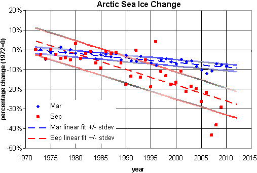
In this graph, areal extent is converted to percentage change from the starting value (areal extent in 1972). Note that the September minimum ice extent (red) has a steeper slope than the March ice extent maximum (blue). Each is shown with bands at +/- 1 standard deviation.
Aside from the noisy September data, there are two problems with this graph:
I suggest that presenting these data as functions of temperature, rather than time, may resolve these problems.
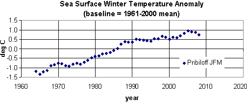
For temperature data, winter sea surface temperature (SST) anomalies recorded at the Pribiloff Islands were smoothed (using a 15 year moving average), producing the graph shown below. This dataset ends in 2008.
Note: Additional Arctic summer time series data are available, but those were not analyzed here. I’ll save that for another day.
In the following plots, the sea ice minima and maxima for the periods of 1972-2008 are shown as functions of this SST anomaly. In each case, the functional fits, with bands at +/- 1 standard deviation, are clearly nonlinear.
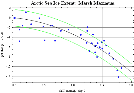
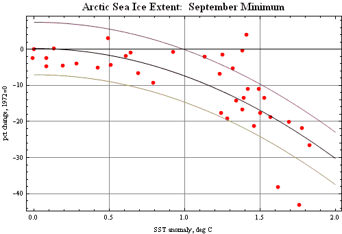
With y representing the percentage change in ice extent and x representing the SST, the function used were:
March maximum, y = -1.196 – 2.186 x2 ;
September minimum, y = 0.253 – 7.620 x2.
Using the 2008 value of the SST in this time series (1.62 deg C), the derivative of these functions provides rates of change in % per degree:
September minimum -0.247 (-24.7% / degree);
March maximum -8.3% / degree.
Thus not only do we expect the annual loss of sea ice to accelerate, we expect the discrepancy between sea ice minimum and sea ice maximum to continue increasing – at least until the sea ice minimum reaches zero. Further, because these temperature data are from the winter months, it may be reasonable to conclude that even a few cold winters just aren’t enough to compensate for the overall warming-induced ice loss.
Posted by muoncounter on Tuesday, 1 June, 2010
 |
The Skeptical Science website by Skeptical Science is licensed under a Creative Commons Attribution 3.0 Unported License. |