The monthly global analysis for October has been released at NOAA's National Climatic Data Center (NCDC) and it reveals that global surface temperature for October 2014 is the warmest October in 135 years of record-keeping. This follows on from the 2nd warmest April, and the warmest May, June, August, and September, ever recorded. In fact the first 10 months of 2014, January to October, are the warmest such period ever recorded, and 2014 is very likely to end up as the warmest year - taking over the title from the previous record year in 2010. Other surface temperature data sets, such as NASA GISTEMP and the Japan Meteorological Agency, also have 2014 on pace to break the annual record.
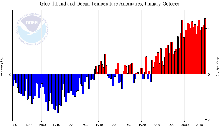
Figure 1 - Global surface temperature anomalies for January-October from 1880-2014. As indicated, 2014 is now the warmest January-October period on record - beating out 1998 and 2010 (tied) by 0.02°C. Image from NOAA NCDC.
With two complete months of data yet to come, it may appear premature in declaring 2014 a likely record-breaker, but 2014 is different to the evolution in surface temperature during 2010 - the previous record holder. Record warm years are typically associated with the development of El Niño events, whereas in 2014 El Niño is yet to even put in an appearance.
El Niño is a periodic, and naturally-occurring, phenomenon in the Pacific Ocean, a time when anomalous heat is discharged from the tropical ocean in response to a temporary relaxation of the trade winds. El Niño typically builds up mid-year, peaks December-January, and then winds down the following year. The 2010 record occurred in the 2nd calender year of an El Niño event and surface temperatures fell throughout that year after April-May. In comparison, 2014 has seen warming from March onwards. 2014 and 2010 are on two contrasting trajectories; a mostly cooling trend in 2010, and a general warming trend in 2014.
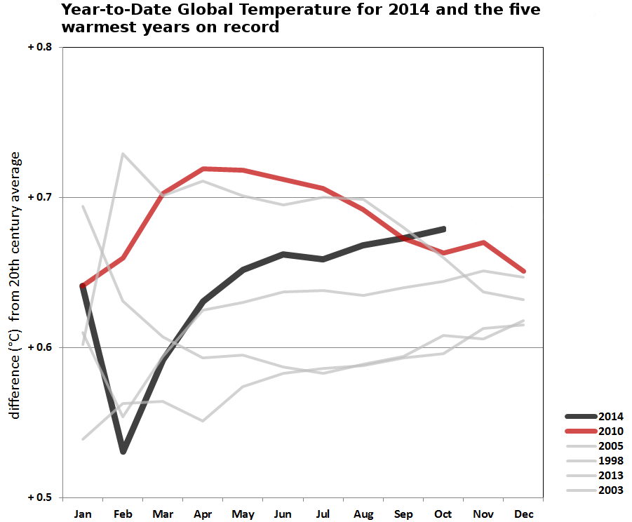
Figure 2 - Comparison of the year-to-date 2014 surface temperature anomaly (or horse race if you like) to the current five warmest years on record. 2010, the previous record warm year, is the key area of interest here - 2014 now has its nose out in front. Image adapted from NOAA NCDC.
So the main reason why 2014 is likely to break the record is that El Niño may only just be forming, and surface temperatures are therefore expected to stay high. Even if El Niño does not take hold, a sizeable Kelvin wave is heading east across the subsurface Pacific Ocean. When this blob of warmer-than-normal water reaches the surface ocean in the eastern Pacific it's likely to keep surface temperatures elevated over a large area.
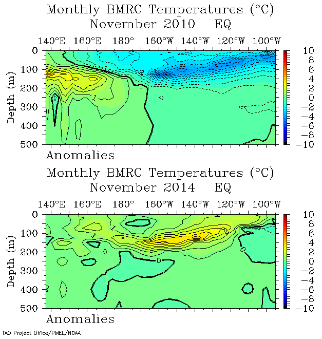
Figure 3 - Pacific Ocean equatorial warm water volume anomalies for November 2010 (top panel) and November 2014 (bottom panel). Unlike 2010, when intense trade winds kept heat buried in the western tropical Pacific subsurface ocean, November/December 2014 looks assured of a warming boost as a pool of warm water (Kelvin wave) heads east toward the American continent and surfaces. Note that these are anomalies (deviations from the norm), not absolute temperatures, so the warmest water is still at the surface. Image adapted from NOAA's TAO Project Office.
Ongoing emissions of planet-warming greenhouse gases, such as carbon dioxide, ensure that global warming will continue for decades into the future, and thus 2014's (likely) reign as the warmest year on record is going to be short-lived - as was 2010's reign. The only outstanding issue is the margin by which 2014 surpasses 2010. For that we will have to wait and see.
Posted by Rob Painting on Thursday, 27 November, 2014
 |
The Skeptical Science website by Skeptical Science is licensed under a Creative Commons Attribution 3.0 Unported License. |