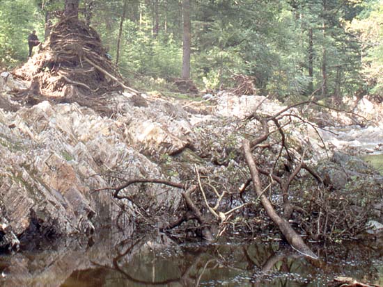
Pulling onto the side of the forestry road the air was thick with a single smell – that of mangled conifer wood. I locked the Land Rover and scrambled down to the river. It was a familiar route, an anglers' path that weaves its way cunningly for several tens of metres through steep, dense undergrowth. But something was different this time. The vegetation ended abruptly some way before it should have done. Where there had been soil, grass, rhododendron and bramble, naked rock now gleamed in the sunshine. Continuing down, I saw that the river, back down to its normal level, had an unusually clouded, milky look to it. Upstream was a prominent bluff of rock, several metres higher than its surroundings, on top of which a large Douglas Fir tree stood. It was still there, but the first few metres of its trunk were thickly and tightly wrapped with branches and tree trunks, their bark stripped away. Scrambling up the tight cone of flood-borne debris, I turned and looked down. It was at least ten metres from the top of the debris-wrap down to the water.
above: aftermath of a huge flash flood in July 2001, Afon Mawddach, North Wales. The figure perched on the left-hand side of the debris-wrap is a good 2 metres tall. Photo: author.
Two days before, a severe thunderstorm had affected the region. Had the area been well-populated, the resulting flash floods would have made the national headlines. Houses would not just have been flooded: some would have been swept away. It served, in the author's case, to raise an awe-struck awareness of just what can happen when the required meteorological ingredients come together. You cannot beat seeing things for yourself.
So: what makes the difference between an ordinary wet day and an extreme rainfall? Judging by the often confused and contradictory comments from online discussions in the wake of the late 2015 floods, this seems as good a time as any for a primer - the three R's of flooding if you like. Rainfall, run-off and rivers. It is aimed primarily at UK readers and a lot of the illustrated examples are from Wales, because that's where I live and they are things that I have seen for myself, but the same principles apply in many parts of the world, outside of the Tropics. Rainfalls in extratropical parts of the world have a complex set of causative factors and effects. This post takes a more detailed look at both. It is by necessity long, because you cannot realistically deal with complex topics in a few soundbites, so it has been divided into sections, linked to by the seven bookmarks below.
Basics: how clouds and rain form
Types of rain: Dynamic Rainfalls
Types of rain: Convective Rainfalls
Types of rain: Hybrid Rainfalls
Run-off: getting rid of the rain once it has fallen
Improving upland resilience to run-off: the Pontbren Project
What happens to the run-off - the third critical factor - rivers
Air can carry a specific maximum amount of water vapour depending upon its temperature. The warmer the air the moister it can be, if a moisture source is available. The value is approximately 7% more moisture per degree Celsius of added warmth, but the equation works both ways thus: if warm, moist air is progressively cooled it can hold less and less moisture. That is a key factor in why rain happens in the first place. Here's how it works.
When an airmass rises it expands, because the higher it goes above Earth's surface, the lower the atmospheric pressure there is to confine it. As the airmass expands, the gas molecules that make it up move outwards and in doing so they have to push other molecules out of their way. The process uses up energy. Temperature is simply an expression of the energy of the molecules in a system, so if energy is used up then the temperature drops. It's the same reason why highly-pressurised gases being squirted from a spray-can feel cold to the touch: they are rapidly expanding on release from the confining environment of the can, doing work against other molecules in the process and consuming energy.
As the air continues to rise and cool it reaches its dew-point - the temperature at which the air can no longer carry all of the water vapor which is mixed with it. Beyond that point, some of the water vapor condenses out into liquid water. When the air temperature cools to the dew point then clouds (or fog or dew) begin to form, nucleating on tiny airborne particles such as dust or pollen. Further cooling of the air leads to even more water vapor condensing since the dew point continues to fall with the air temperature.
The water droplets forming clouds are pulled downwards by gravity but they are so tiny (no more than a few microns in diameter) that their descent-speed is so slight as to be negligible. It is only when they start to merge together, coalescing to form larger droplets, that rain becomes possible. As the fledgling raindrops move around via gravity and turbulence, they collide together and get larger in the process, until a point comes where they are big enough to fall to the ground.
At height, or at lower levels in cold conditions, the water droplets in a cloud will freeze, the resulting ice crystals growing at the expense of the water vapour. Once they are heavy enough to start to fall, countless collisions with other ice-crystals lead to the formation of snowflakes. Three things can then happen. The flakes will either fall all the way to the ground if conditions are cold enough, partially melt to form sleet or, as mostly happens, completely melt back into rain.
A complication can occur if the atmosphere is stratified, so that a near-ground layer of freezing air is capped by a temperature-inversion, with warmer air above and freezing air again at height. Snowflakes then melt in the warm air as they fall through it: they have insufficient time to re-freeze as they plummet through the freezing air near the ground and fall onto the frozen surface, leaving everything coated in ice. Freezing rain, also referred to as an ice-storm, is an uncommon and particularly hazardous form of weather.
Mechanisms by which airmasses undergo lifting are varied, but the simplest division when it comes to rainfall is twofold: dynamic and convective. Dynamic rainfalls involve air being mechanically lifted and cooled. The lifting may occur at an airmass-boundary – a weather front (frontal rainfall) or a barrier of higher topography (orographic rainfall).
Frontal rainfall occurs when a cooler airmass is driven into a warmer airmass or vice-versa. At the boundary between them - the warm or cold front - the warm air rises up over the relatively dense cold air. As the warm air rises it cools and rain starts to fall. Dynamic rainfalls from fronts can become problematic if a frontal boundary stalls over a district, so that the rain is prolonged over a day or more.
Orographic rainfall is particularly important along the western seaboard of the UK, with its mountainous hinterland facing into the prevailing wind blowing in off the warm Atlantic. When weather-patterns cause long-fetch south-westerly winds to blow, a constant flux of very moist, warm air is delivered to the coastline and is then lifted over the mountains where cooling and copious precipitation are the results. In some cases, bands of particularly intense moisture-flux, up to a few hundred kilometres in width but thousands of kilometres in length, come streaming in off the ocean. If these moisture-laden conveyor-belts remain in the same place for a day or two, the orographic rainfalls they produce can lead to severe flooding. The Lake District flooding of early December 2015 (with over 300 mm of rain falling in 24 hours in places) was a classic example of this phenomenon, known appropriately enough as an Atmospheric River.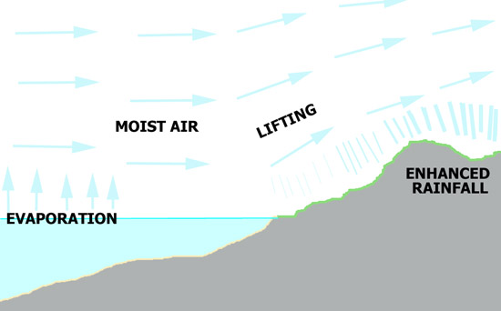
above: simplified sketch showing how rainfall is orographically enhanced when warm, moist air is forced up over a mountain range. Image: author.
Atmospheric Rivers typically occur low in the Troposphere, between 1 and 2.5 kilometres above surface. But orographic lifting does not just affect air at low levels: it often involves the full depth of the Troposphere. Ice particles falling from high cloud can then dramatically enhance the rain production process: as they fall into lower, very moist air they literally seed that air with countless condensation nuclei. Known as the “seeder-feeder” mechanism, as far as the folk on the ground are concerned it only makes a bad situation worse.
Convective rainfalls occur when air rises due to its own buoyancy being greater than that of its surroundings. In such a situation, the atmosphere is said to be unstable. The buoyancy is obtained in a variety of ways. Simple heating of an airmass at low levels, so that it starts to rise, is one mechanism. At other times, a bit of a dynamic shove is required to start the process off, by physically lifting an airmass to a level at which it becomes buoyant and can start to rise under its own steam.
Let's start with simple heating. Heat sources can be solar radiation, warming the ground surface, or warm sea surfaces due to high sea temperatures. When the ground warms up, any moisture that is present can evaporate. The hot ground also heats the air above it. As a result, a warmed airmass with added moisture will start to rise vertically, encountering as it ascends a progressively colder surrounding atmosphere, which only adds to the buoyancy. With sufficient moisture and warmth, a buoyant airmass can shoot right up to the Tropopause, the major temperature-inversion capping the Troposphere.
As such an airmass rises it expands, cools, its moisture condenses out and what we end up with is the familiar anvil-topped thundercloud, or cumulonimbus. The top of the anvil marks the Tropopause. A similar mechanism occurs out at sea, but in that case the sea warms the air passing over it and supplies it with moisture through evaporation. Ideal conditions for sea-based convection are those times of year when the sea is at its warmest but cooler airmasses are flowing over it. In the UK, such thunderstorms tend to occur in cold northerly airflows in the autumn and winter and they often wane once they move over the land, their fuel-supply having been cut off.
Thunderstorm updraughts can be extremely powerful, which is why they can produce hail. Hail forms when water droplets rise to heights that are below freezing level: the water becomes supercooled and it will freeze on contact with condensation nuclei. Hailstones may be repeatedly circulated within a thundercloud, adding a bit more ice each time, until they are heavy enough to overcome the updraught and fall to the ground. Most hail is only a few millimetres in size. However, stronger, more organised storms, with long-lived and very powerful updraughts kept separate from the downdraughts by favourable wind-shear, can generate much larger hailstones because of the amount of time they have had to grow.
Physically lifting an airmass to a level at which it becomes buoyant involves a few different mechanisms. Surging cold fronts, lifting warm air as they drive in beneath it, are often capable of producing line-convection – all that's needed is a good bit of lift and instability above. The point of the wedge – the surface cold front – is the focus of the lifting. Where instability is present, a long, narrow line of very heavy rain and high winds forms. Looking like a length of brightly-coloured rope on a rainfall radar plot, such cold-frontal squall-lines can be capable of causing flash-flooding but most of the problems associated with them are caused by high winds, which may include tornadoes and particularly microbursts, caused by strong downdraughts surging down to the surface and fanning out over the ground.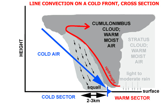
above: sketch section through an active, surging cold front. The squall-line forms right at the surface front's leading edge (author).
below: radar signature (from Netweather) showing a squall-line - the brightly coloured linear feature - crossing Wales. To its east dynamic rain is falling from the warm sector, to its west dynamic rain is falling from the cold front at height. Rainfall rates in mm/hour.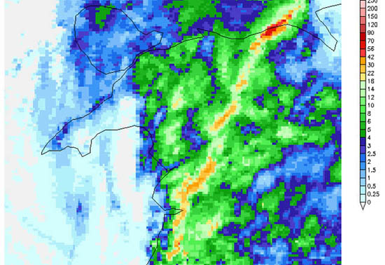
Other foci for convective rainfalls include troughs, elongated zones of low atmospheric pressure featuring instability, lift and therefore air buoyancy. The 2001 storm that produced the flooding described at the start of this post developed along a slow-moving trough on a hot July day on which the atmosphere was very unstable. Slow-moving summer thunderstorms of this nature can be especially damaging because with relatively high temperatures there can be an awful lot of moisture present and long-duration intense rainfalls can result.
Sea-breezes are a phenomenon of the warmer months in coastal counties. Warm air rises over the land due to solar heating and cooler air pours in from the sea to replace it. The cool air forms a frontal boundary with the warmer air it meets inland and along this line the warmer air is undercut and given additional lift. The process, with one airmass meeting another, is referred to as convergence. In the UK, intense convergence-line storms may occur in slack pressure setups, when the winds are light so that the storms remain in the same area. For example, if a sea-breeze from a west-facing coast converges with a gentle synoptic flow from a northerly or southerly direction: the ground beneath the convergence-line can experience repeated thunderstorms over several hours. The storms develop and move along the line like the trucks on a train going by, which is why such systems are known as “train-echoes” from their radar signature. They can prove dangerous: the 2004 Boscastle flood was caused by one which dumped up to 200 mm of rainfall in a single afternoon.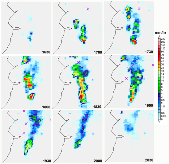
above: Netweather radar composite time-series showing a train-echo thunderstorm line over the Welsh mountains, June 2009.
below: the same storm system in person. Note the very sharp boundary to the torrential rainfall. Photographed from the east, looking south-west, by the author.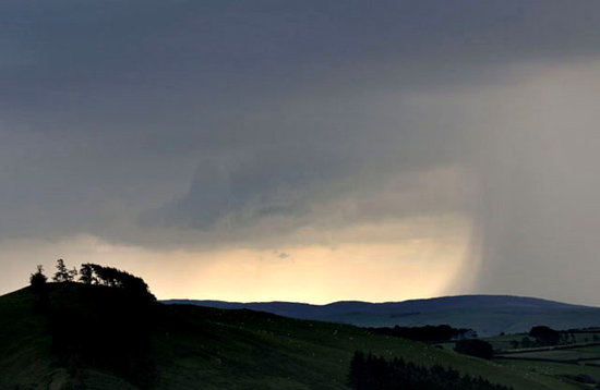
The prediction “Rain spreading up from the south, locally heavy and thundery” is something that is often heard in UK weather forecasts during the warmer months. It refers to plumes of warm, moist and potentially unstable air moving up from the south or south-west. “Thundery rain” can range in nature from the odd embedded thunderstorm in an area of largely dynamic rainfall up to what is known as a Mesoscale Convective System (commonly abbreviated to MCS), where large-scale destabilisation has occurred resulting in a giant thunderstorm cluster covering hundreds of square kilometres, often accompanied by prolific lightning.
In the UK, the summer of 2007 was notorious for its heavy downpours and severe flooding. By the end of the year, insurance claims for flood-damaged properties and businesses were approaching £3 billion. The events of 19th -21st July stand out for their great extent and severity. They involved a mixture of convective and dynamic, orographically-enhanced rain. On the 19th, thunderstorms developed widely over England, Wales and Ireland, with locally severe flash flooding. By the 20th, heavy and locally thundery rain was affecting much of the southern half of England, tracking slowly north-west throughout the day. Parts of the Midlands saw unusually high day-totals well in excess of 100 mm of rain. Severe flash flooding occurred across the southern Midlands, the Home Counties and Central Southern England, with helicopter evacuations in places and hundreds of roads and railways closed by floodwaters. But that was only the start.
Overnight into July 21st, the rain, no longer with any convective elements, moved into Wales. In the reverse of the more typical dynamic rainfall pattern, the moist air approached the Welsh mountains from the east. Orographic lifting of the air led to prolonged heavy rain over the Welsh uplands, about the last place it was needed. The mountains of Mid Wales are drained by the longest river in the UK – the Severn. The river flows through the English Midlands before draining into the Bristol Channel, so that it was already in spate due to the deluges of the previous day. The Severn now received a second surge of run-off moving downstream from the mountains. Environment Agency river gauges recorded the peak flow as it made its way downstream. Near Worcester the peak was on 22nd July, whilst near Gloucester it occurred on the 23rd. The peak flow at Haw Bridge, between Worcester and Gloucester, was estimated to be nearly 1400 cubic metres per second, a phenomenal amount of water. The drainage-system of the Severn Basin, primed by convective flash-floods, was then completely over-run by dynamic, orographic rain. Thousands of homes were flooded and power and drinking water supplies were badly affected, for weeks in some cases.
Flooding does not entirely depend on the total amount of rainfall that is received by a river catchment during any one event. There are a number of other factors that can affect the outcome. First we'll look at rainfall intensity. Having observed and photographed convective storms for many years, the author has noted that there is an apparent threshold rainfall rate above which flash-flooding is likely to begin. That value is around 60 mm per hour. In the UK, such rainfall rates are only met with in convective storms, mostly occurring during the warmer months of the year. Often, such storms are short-lived, or they move through too quickly to do much damage. However, a more organised convective system can hammer the same bit of country for several hours. Examples like the train-echo storm that caused the Boscastle flood can turn a bit of inconvenient road-flooding into something far more serious.
For dynamic rainfalls, rainfall rates of over 25 mm per hour tend to be uncommon. It is their long persistence and the vast areas that they affect that make them potential flood-generators. Mostly they just bring river levels up a bit, but when a frontal system becomes quasi-stationary, big trouble can ensue, especially when a long-fetch Atmospheric River is involved, as was the case in early December over the UK's western seaboard mountains. Even if the rainfall rate never exceeds 10 mm per hour, it's easy to see how 36 hours of such weather can spell trouble.
A single example will suffice to point out the sheer amount of rainwater involved in such situations. In the Lake District, the catchment of the River Derwent is 1,235 square kilometres and in the 4th-5th December deluge, some of its hillier parts received 24-hour rainfalls of more than 300 mm. Just a hundred millimetres of rainfall over that catchment would deposit 123,500,000 cubic metres of rain-water. That's 123,500,000 tons of water to get rid of. The severity of the outcome of such an event depends, though, on the ground state beforehand because that will determine the rapidity of the rainwater run-off. That rapidity is a key factor in determining whether there will be flooding and how bad it may be: in a nutshell, the slower the run-off, the better.
One problem in recent weeks has been ground saturation. Because the Atlantic has been throwing one low pressure system at the UK after another, there have been times when the ground simply cannot take in any more water, so that rainfall run-off has been close to a hundred percent. The mountains of the western UK are mostly made up of Lower Palaeozoic sedimentary and igneous rocks whose permeability tends to be on the low side. Not only that, but vast areas are mantled in till. Till consists of deposits of stony grey, often impermeable clay left behind by the last glaciation. Such bedrock and superficial deposits can pond the water in any areas of low topographical relief, so that peat bogs are locally extensive. The peat bogs act as great sponges, absorbing a lot of water before reaching saturation-point, but after such prolonged heavy rainfalls that point is nevertheless reached.
Peats also form on slopes, but what tends to happen in such cases is that subterranean watercourses form beneath the peat, which is permeable, and on top of the till, which isn't. Such watercourses eventually emerge downhill as springs in normal conditions, but if they become overloaded with water, it starts to force the peat and overlying turf upwards: the ground bulges until it is over-pressured and a bog-burst landslide takes place. Such landslides are common in the western mountains wherever till deposits are present.
A variant on the theme of saturation is frozen ground. One situation that sometimes occurs is that a cold spell, with the mountains frozen-up, is followed by a rapid switch to mild, moisture-laden sou-westerlies bringing heavy and prolonged dynamic rains. Until the frozen ground thaws out it cannot absorb the rainfall. Another scenario occurs when the mountains are snowbound and the switch to sou-westerlies takes place. The mild, moist air then facilitates a rapid thaw, adding melt-water to the equation, as happened in March 1947, after one of the coldest and snowiest winters of the 20th Century.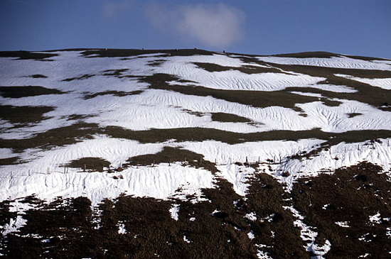
above: snow and ice can enhance rainfall run-off. Here, compacted old snow is widely gullied by run-off channels. Dylife, Mid-Wales, March 2007. Photo: author.
Although the relative impermeability of the UK's western mountains is a disadvantage, there is evidence that there are ways in which we can mitigate the rapid run-off problem. It is becoming increasingly apparent that land-use can affect the containment of run-off, for better or for worse. Some interesting research has been ongoing for a number of years in the catchment of Nant Pontbren, a tributary of Afon Banwy (itself a tributary of the Severn) near Llanfair Caereinion in Mid-Wales. Here, in 1997, a group of neighbouring farmers became interested in building in resilience on their land. Working together, and expanding as a group after a few years to take in more farms, they planted extensive shelter-belts of trees, reduced grazing intensity and constructed numerous ponds. One unexpected consequence is best described in a report by Coed Cymru, which is well worth a read (PDF here). I'll quote from the report:
“The huge research programme at Pontbren began with a chance observation by Coed Cymru’s director, who was walking across sheep grazed pasture during heavy rain on a visit to one of the farms in 2001. He noticed that water running downhill across the grazed fields disappeared as soon as it reached the edge of the new woodland, and the farmers confirmed that they too had noticed this.
Centre for Ecology and Hydrology (CEH) Bangor was invited to follow this up with a simple soil investigation, and they took measurements comparing the speed at which the soils under the pasture and those in the fenced off woodland could absorb water. The results were striking, showing that the infiltration rates inside the woodland were 60 times those on the pasture ten metres away, and that the beneficial effect extended beyond the edge of the woodland. The reasons were unclear, and previous research was little help, because much of it applied to the tropics, and the limited body of research in Europe tended to focus on woodland or farmland or, in the UK, on coniferous plantations on drained peat soils. Pontbren was quite different, because strips of native broadleaf woodland had been planted within sloping, improved grassland. The farmers readily agreed to more detailed research, with monitoring equipment installed and experiments set up on their land, although this would mean some disruption to their work and regular access by the scientific staff.”
Sloping improved grassland describes large parts of the Welsh uplands away from the higher spine of the country, so that the potential to do more projects like the one at Pontbren, managed entirely by the farmers, is in fact massive. It is clear from the work done in the Pontbren Project that shelter-belts slow down rainfall run-off to a significant extent. They also provide shelter for livestock and wildlife corridors, so the benefits are multiple. To what height above sea-level (ASL) such practices can work in Wales is yet to be determined. My observations, from many years spent wandering these hills, are that above about 550 m ASL one often encounters an Arctic-Alpine flora dominated by clubmosses and dwarf sedges. I would therefore contend that there is still a tree-line in the Welsh uplands at around 550 m ASL, higher still in places sheltered from the prevailing sou-westerly gales. However, in areas of clear-felled conifer-forest as high as 400-500 m ASL, one often finds areas of self-seeded scrubby willow, alder, birch and rowan. Left to their own devices, trees are colonising such areas. It's a rewilding experiment that has happened all on its own. Land above 550 m ASL is in any case a relatively small percentage of Wales' total surface area. 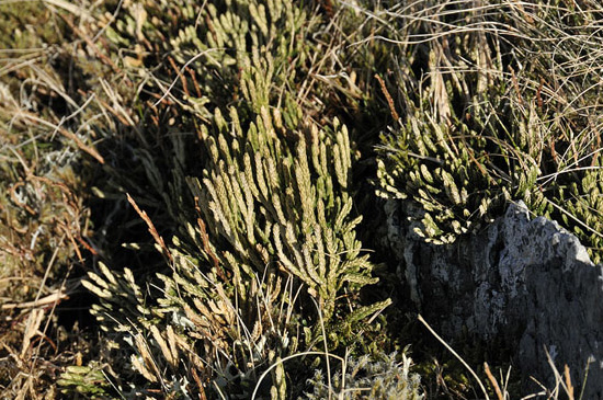
above: Arctic-Alpine clubmoss-rich flora above the 550m ASL contour, Plynlimon, Mid-Wales, March 2014.
below: self-seeded willow-dominated scrub regenerating in old clear-fell at around 450m ASL, in the hills above Tregaron, Mid-Wales. Photos: author.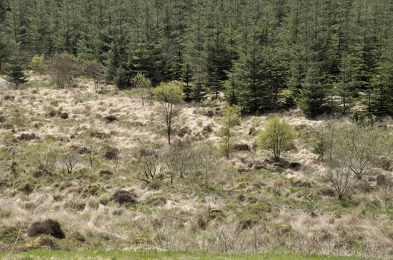
Elsewhere, changes are taking place in the UK's uplands with the restoration of blanket peat bogs, many of which were formerly drained for conifer forest plantations or for game-shooting. Many such boglands date back from Bronze-age times, when they first started to form over nutrient-poor upland soils. Prior to that, it is thought that many such upland areas were wooded (see photo below for evidence): whether nutrient depletion, climate change, grazing or deliberate clearance was to blame for the demise of the woodland (or a combination of the four) is still debated. Again, one effect of such projects will be to slow down the run-off from the uplands. It is, however, only happening locally and many upland areas are still being drained and burned, practices that have led, especially in recent weeks, to a lot of heated discussion. See here for example.
Even in upland areas that are ploughed or ditched, adjustments to methodology can be made to delay run-off. In particular, ditching or ploughing along the contours is a far better practice compared to draining a hillside radially – straight downhill. The upland area is still drained but the rapidity of the run-off is markedly reduced.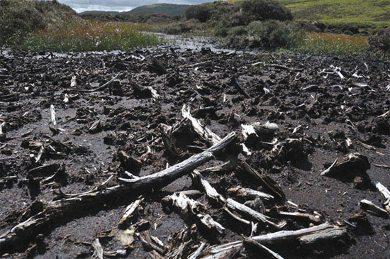
above: old peat-diggings at around 450 m ASL in the Plynlimon massif. Ancient bogwood is common in places, indicative of the woodlands that once grew here. Associated rare finds of early Bronze-age arrowheads at the same level in the peat suggest that the wood here is some 4,000 years old. For an interesting account of how the upland flora of North Wales developed after the last ice-age, this 2003 paper is well worth a read. Photo: author.
However, the Pontbren project shows that if the effort put into blaming one another for problems (ref: most politicians on a daily basis) was instead put into solutions, we can actually get something done - and also still have a living, working landscape. Climate change is highly likely to lead to an increase in both frequency and intensity of severe rainfall events, but there are steps we can take to mitigate the impacts of such episodes. It's not about stopping the run-off: it's all about slowing it down. The uplands of the UK are our ally here if we treat them with wisdom.
Once the rain has run off the ground surface, the water finds itself in the drainage system. Drainage refers to anything from tiny streams to large rivers: all are driven by gravity and all have the sole function of conveying the water to its lowest possible altitude. In almost all cases, that is the sea.
Upland streams tend to have a steep gradient, bringing the water off high ground by as direct a course as possible, although both bedrock and superficial geology interfere. Thus, beds of especially hard rock, resistant to erosion, may affect the course of a stream: likewise a stream may flow around a large accumulation of glacial moraine. Sediment in upland streams is derived from the slow erosion of rocks and the more rapid erosion of glacial till and other superficial deposits. Upland streams can frequently seen to be cutting into till deposits, forming retreating low cliffs.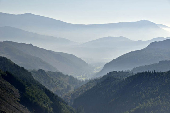
above: from upland to lowland: a view down the valley of Afon Wen, North Wales. It flows straight down this steep-sided, v-shaped valley with a considerable gradient, descending some 140 metres in just 3.5 kilometres to reach the lowland flood-plain of Afon Mawddach, visible in the distance. Photo: author.
Because of the steep gradient, upland streams are fast-flowing and energetic. In spate, they can transport sediment grains up to large boulder size. Lowland rivers are, in contrast, much slower-flowing, especially in their lower reaches as they approach their estuarine parts. Here, the sediment load is primarily mud through silt to fine sand-sized, the grainsize rarely exceeding 0.25 millimetres. But there's a lot of it. In most of the UK, the landscape of the lowlands emerged as the ice-sheets began to retreat 20,000 years ago. Take the lowland part of the Severn catchment, for example. Consisting of often soft Mesozoic sedimentary rocks draped by glacial and post-glacial sediments topped by rich soils, it has been repeatedly modified by end- and post-glacial processes and finally by Man. There's an awful lot of easily-eroded sediment to add to the river's load brought down from the uplands. Land use again has a strong influence in the lowlands, with agricultural techniques that inadvertently promote soil erosion being a massive problem. George Monbiot, writing in the Guardian in February 2014, noted of the uplands adjacent to the Somerset Levels:
“you can see field after field of harvested maize. In some places the crop lines run straight down the hill and into the water. When it rains, the water and soil flash off into the lake [JM – the flooded Levels]. Seldom is cause and effect so visible. “
Such practices are bad for two reasons. Firstly, in more normal conditions the fine-grained fraction of the soil – the mud – ends up in river systems where it is transported and redeposited along slow-flowing sections, ultimately impeding the normal flow, meaning that dredging is required just to keep up with things. Secondly, soil is a precious natural resource that should not be wasted in this manner.
In its unadulterated state, a lowland river will meander sluggishly across its flood-plain. Meanders form when a river's course starts to curve: sediment will be eroded on the outside edge of the curve and will be deposited on the inside edge. Thus any one meander will gradually advance seawards along the flood-plain, with sediment entering the water through erosion and being replaced by deposition. Meanders are important because they effectively lengthen a river: a meandering river can be twice the length of a straightened one. Thus they reduce the river's gradient. In normal flows, the water therefore takes longer to reach the sea: as it flows more sluggishly, the water has less energy and thus less erosive power.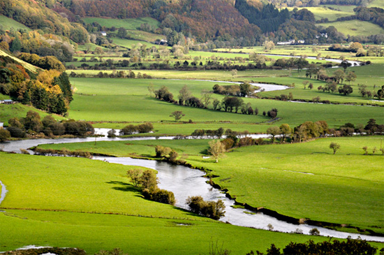
above: Afon Dyfi meandering along its lowland flood-plain near Machynlleth, Mid-Wales. I have calculated that although this section of the valley is just 3.5 kilometres in length, the river's course is some 5.2 kilometres long. Photo: author.
The reason why reducing erosive power is important is because the greater that power the more sediment ends up in the system. It is no good straightening and dredging a river if it is only going to increase the sediment load. That sediment will end up being deposited somewhere downstream, slowing its flow. Likewise, an increased flow-rate simply carries off flood-water more quickly – until, that is, it reaches the next constriction downstream. Such a constriction might be a bridge, the confluence with a large tributary or, indeed, a river's tidal reaches where, during the flood-tide, the river's flow will either be slowed or reversed. The latter process is known as tide-locking. In each case, the river's flow will be impeded and the water will start backing-up along its main channel, until it overtops its banks and starts to fill its flood-plain. Remember, you can in theory replace bridges, making them bigger, but you cannot prohibit tributaries nor ban tides.
Flood-plains are important natural features that absorb and convey the waters in major floods, when the peak flow may be many times more than the main channel capacity, known as the bankfull discharge. Even a dredged main channel can only carry a fraction of the water conveyed by the entire flood-plain in a major event. Thus, although in some specific instances, dredging has its uses in flood mitigation, it is not the catch-all simple solution that some people consider it to be. When faced with the sheer amount of water produced by a major rainfall event, rivers will have to use their flood-plains regardless. It's what they are for. An excellent report by the Blueprint for Water goes into much greater detail than is possible here (PDF).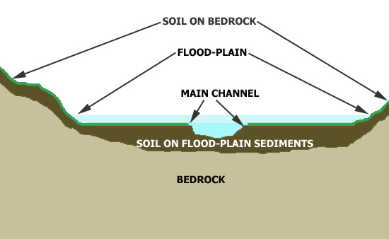
above: a schematic cross-section through a lowland river and its flood-plain. When a big flood occurs (pale blue), the flood-plain carries vastly more water than the main channel (blue) could ever manage. Graphic: author.
Likewise, it is often said that floods happen due to building on flood-plains. This is back-to-front: the accurate way to state the facts is that flood-plains are where floods occur, so if you build on them you can expect the properties to get flooded from time to time, as the vast majority of the water is coming from uplands, many miles upstream, where a dumping of 100-300 mm of rain occurred a day or two ago. One tends to notice that older settlements were mostly built away from the immediate vicinity of lowland rivers. My home-town, Machynlleth, is occasionally cut-off to its north and south by flooding because the main roads have to cross the flood-plain of the Dyfi. However the town itself is rarely affected because when the settlement was founded they chose to situate it off to one side, a good ten metres above the flood-plain itself.
Finally, some (especially the UK's right-wing tabloid press) are using the recent floods for political purposes, specifically blaming the floods on the European Union "banning river dredging". What they are referring to is the European Water Framework Directive (2000). I have just been taking a look for myself. It's here. A supplementary Directive from 2008 (here) is the only place on that part of the site where I could find a single instance of the word "dredging":
17) In accordance with Article 13 of, and Annex VII(A)(5) to, Directive 2000/60/EC, any exemptions to the application of the EQS for priority substances applied to water bodies in accordance with Article 4(4), (5) and (6) of that Directive, taking into account Article 4(8) and (9) thereof, should be reported in the river basin management plans. Provided that the requirements of Article 4 of Directive 2000/60/EC including conditions for exemptions are met, activities, including dredging and shipping, leading to discharges, emissions and losses of priority substances can take place.
Dredging has not, of course, been banned by the EU. In recent years quite a lot of dredging has taken place - at locations where it is deemed useful among the various flood protection measures available to the UK authorities. See here, for example. No, the problem is an increase in both the frequency and intensity of extreme rainfall events, so that what were considered to be rare events are now occurring every few years: Cumbria has now been hammered by severe flooding three times since 2005. Whether or not similar clusters of severe floods have happened in the distant past is irrelevant since it is the present that we are having to deal with. The bottom line is that if you dump a foot of rainwater in a day over hundreds of square kilometres of already saturated uplands, you will get major flooding in the catchments that drain them. As discussed above, a wide spectrum of site-specific measures is required to address the effects of such events.
To reinforce the above points, here are some statistics with regard to December 2015, from the Centre for Ecology and Hydrology (link). Whatever the pick 'n' mix attempts at counter-arguments, these figures, quite simply, speak for themselves:
a) New 24-hour rainfall record for UK (341.4mm, Honister Pass)
b) New 48-hour rainfall record for UK (405.0mm, Thirlmere)
c) Wettest calendar month on record for UK (191% of December average) in a series from 1910
d) Largest ever flows recorded on English rivers (~1700 cubic metres per second) on the Eden, Lune and Tyne)
e) Highest peak flows on record for many northern rivers
f) New maximum daily outflow from the UK (in a series from 1980), a third larger than previous maximum
g) Warmest December in a series from 1910 (4.1C above average)
It is hoped that this primer has given readers an insight into the complex nature of flooding. Flooding has a variety of causes that involve weather and how that is being affected by climate change, land-use and ground conditions and how they affect rainfall run-off and the functionality of our rivers and their flood-plains. There is no single catch-all magic trick to prevent flooding, but there are ways of reducing its overall impact. However, in some cases they will involve tough long-term decision-making as we begin to adapt to a changing climate in the coming years and decades.
Posted by John Mason on Tuesday, 19 January, 2016
 |
The Skeptical Science website by Skeptical Science is licensed under a Creative Commons Attribution 3.0 Unported License. |