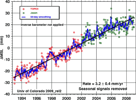
Figure 1: Satellite altimeter measurements of the change global mean sea level with inverse barometer effect (University of Colorado).
What The Science Says:
Sea levels are measured by a variety of methods that show close agreement - sediment cores, tidal gauges, satellite measurements. What they find is sea level rise has been steadily accelerating over the past century.
Climate Myth: Sea level rise is exaggerated
"We are told sea level is rising and will soon swamp all of our cities. Everybody knows that the Pacific island of Tuvalu is sinking. ...
Gavin Schmidt investigated the source of the specific claim that tide gauges on islands in the Pacific Ocean show no sea level rise, and found that the data show a rising sea level trend at every single station. But what about global sea level rise?
A common error in climate debate is drawing conclusions from narrow pieces of data while neglecting the whole picture. A good example is the recent claim that sea level rise is slowing. The data cited is satellite altimeter measurements of global mean sea level over the past 16 years (Figure 1). The 60 day smoothed average (blue line) seems to indicate sea level peaked around the start of 2006. So one might argue that sea levels haven't risen for 3 years. Could one conclude that the long term trend in sea level rise has ended?
Figure 1: Satellite altimeter measurements of the change global mean sea level with inverse barometer effect (University of Colorado).
To answer this question, all one has to do is view the entire 16 year dataset. A noisy signal is imposed over the long term trend of sea level rise. These fluctuations mean there will be short periods where sea level shows no trend. For example, 1993 to 1996 or 1998 to 2000. In other words, there have been several short periods of several years over the last 16 years of steady sea level rise where sea level appears not to rise.
This is inevitably the case when you have a noisy signal imposed over a long term trend. We see exactly the same phenomenon occur in the temperature record (which is why we also see the same erroneous conclusions). The lesson from this is to treat with skepticism anyone who concludes long term trends from several years of a noisy signal (after all, skepticism should cut both ways).
In addition to this, Figure 1 is a particularly noisy signal because it displays unfiltered data. Sea level is subject to the "Inverse Barometer" Effect. This is where sea level is depressed in areas of high atmospheric pressure, and raised in areas of low pressure. When barometric pressure effects are filtered out, the result is a less noisy signal and a clearer picture of what's happening with sea level.
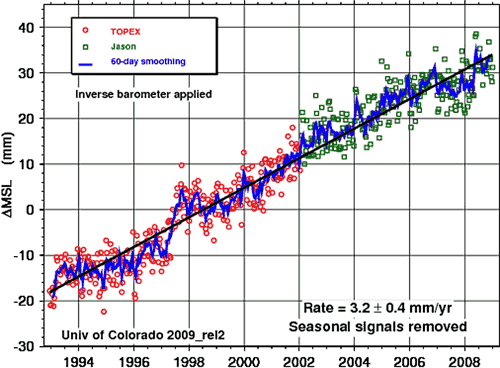
Figure 2: Satellite altimeter measurements of the change global mean sea level with inverse barometer effect filtered out (University of Colorado).
Global mean sea level (eg - the global average height of the ocean) has typically been calculated from tidal gauges. Tide gauges measure the height of the sea surface relative to coastal benchmarks. The problem with this is the height of the land is not always constant. Tectonic movements can alter it, as well as Glacial Isostatic Adjustment. This is where land which was formerly pressed down by massive ice sheets, rebounds now that the ice sheets are gone.
To construct a global historical record of sea levels, tide gauge records are taken from locations away from plate boundaries and subject to little isostatic rebound. This has been done in A 20th century acceleration in global sea-level rise (Church 2006) which reconstructs global sea level rise from tide gauges across the globe. An updated version of the sea level plot is displayed in Figure 3:
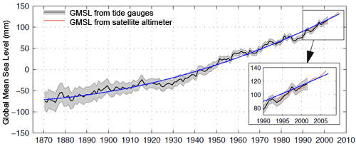
Figure 3: Global mean sea level from 1870 to 2006 with one standard deviation error estimates (Church 2008).
Tidal estimates from sediment cores go even further back to the 1300's. They find sea level rise is close to zero in the early part of the sedimentary record. They then observe an acceleration in sea-level rise during the 19th and early 20th century. Over the period where the two datasets overlap, there is good agreement between sedimentary records and tidal gauge data (Donnelly 2004, Gehrels 2006).
What we're most interested in is the long term trends. Figure 2 shows 20 year trends from the tidal data. From 1880 to the early 1900's, sea level was rising at around 1mm per year. Throughout most of the 20th century, sea levels have been rising at around 2mm per year. In the latter 20th century, it's reached 3mm per year. The five most recent 20-year trends also happen to be the highest values.
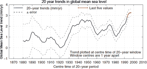
Figure 4: The linear trends in sea level over 20-year periods, with one sigma error on the trend estimates shown by the dotted lines. From 1963 to 1991, there were a series of volcanic eruptions which caused cooling and hence contraction of the upper ocean. This temporarily slowed the rate of sea level rise.
So a broader view of the historical record reveals that sea level is not just rising. The rate of sea level rise has been increasing since the late 19th century.
Intermediate rebuttal written by dana1981
Update July 2015:
Here is a related lecture-video from Denial101x - Making Sense of Climate Science Denial
Additional videos from the MOOC
Expert interview with Richard Alley
Expert interview with Isabella Velicogna
This rebuttal was updated by Judith Matz on September 13, 2021 to replace broken links. The updates are a result of our call for help published in May 2021.
 |
The Skeptical Science website by Skeptical Science is licensed under a Creative Commons Attribution 3.0 Unported License. |