The truth is incontrovertible. Panic may resent it, ignorance may deride it, malice may distort it, but there it is. Winston Churchill, 1916.
Late summer has long been known in media circles as the Silly Season, when any old story, embellished a bit here and a bit there, is trundled out to fill column space normally occupied by the graver matters of politics and business.
In the world of climate science, late summer is of course rather more important, marking the peak of the annual sea-ice melting season of the Northern Hemisphere, and this year has been extraordinary, with the canary in the coal mine tweeting louder than ever that something is seriously amiss with the climate.
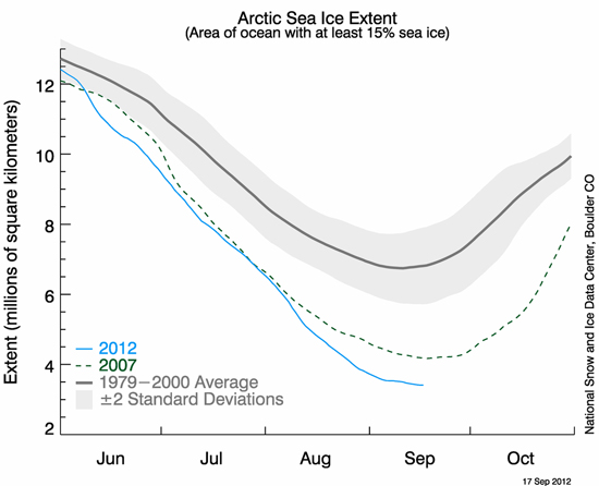
With Arctic sea-ice having reached a record low extent, area and volume, several weeks ahead of the usual end-of-melt date, the Blogosphere has been ablaze with lengthy discussions of this event and its potential and worrisome ramifications. There have also been mass-outbreaks of denial accompanied by varying degrees of silliness, as one might expect when faced with an event like a record Arctic melt-out. Many commentators could see the meltdown approaching, both in the Arctic and around parts of the Blogosphere, with Gareth Renowden over at Hot Topic speculating in early August as follows:
"When Arctic sea ice area sets a new record low in the next couple of weeks, the usual suspects will say: “You can’t trust area, sea ice extent is the only valid metric“.
When Arctic sea ice extent sets a new record low in September, the following arguments will be run in parallel:
1) There will be a frantic search for a definition of extent in which a new record was not set2) There will be a complaint that the satellite record has been blighted by the failure of a sensor and the calibrations needed to get a new sensor in operation have corrupted the record
3) It will be claimed that it was all caused by the major Arctic storm that hit in August, and thus can’t be attributed to global warming
4) It’s cyclical — it’s all happened before, in the 1930s, and is therefore nothing unusual
5) That it’s irrelevant, because it’s not global and not happening where anyone lives so can’t possibly matter.
When the sea ice extent and area anomalies blow out to record levels in early October because of the delayed freeze-up, there will be silence.
When the re-freeze starts, and the Arctic basin is covered in ice once more (early December), Anthony Watts will report on the record rate of ice formation, calling it a “stunning recovery“."
They go on in strange paradox, decided only to be undecided, resolved to be irresolute, adamant for drift, solid for fluidity, all-powerful to be impotent. Winston Churchill, 1936.
How closely did Gareth's predictions above conform to the reality on the media airwaves? In this post-minimum-declared Blogosphere round-up, we take a light-hearted look.
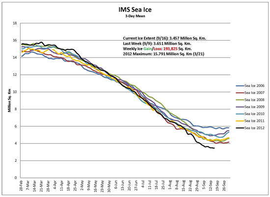
In terms of searching for definitions of extent that failed to break the record (prediction #1), one set of data became increasingly popular in fake-sceptic circles - the IMS data. However, in clutching at this particular straw, its eager proponents overlooked a rather important point: IMS (acronym for Interactive Multisensor Snow and Ice Mapping System) is specifically intended for marine navigation, not climate monitoring, purposes. The eminently sensible idea is to map as much ice as possible as accurately as possible each day and week in support of ships (particularly DoD ships) operating in and near ice-covered waters. As a consequence, areas with too low an ice concentration to show up as extent on the NSIDC, DMI or JAXA dataplots are very sensibly counted as icy because of the potential hazard to boats not equipped to sail through such waters. In other words, IMS is an orange in amongst a basket of apples. Or (false balance alert), as IMS fan Steve Goddard put it in his so-called 'Real Science' blog on August 25th:
"The National Ice Center is in the business of being accurate and saving lives, while [the University of] Bremen is in the business of obtaining global warming grant money."
That is a comment that needs no further comment from me. Meanwhile, evidently unflattered by such favouritism, the IMS dataset went on to take a nosedive all of its own and broke its record in early September:

Prediction #2 gained relatively little traction but maybe that was because prediction #3 - blaming the situation on the cyclonic windstorm that occurred in early August - was so easy to run with. But hold on a moment. The melt-rate prior to the storm was such that a record was inevitable anyway - the storm only increased melt-rates for a few days.
Furthermore, whilst such storms are indeed uncommon, the early August gale was not an unprecedented event. Who says so? Paul A. Newman, chief scientist for Atmospheric Sciences at NASA's Goddard Space Flight Center, estimates that there have been about eight storms of similar strength during the month of August in the last 34 years of satellite records. And there's a second factor: ice-quality (an often overlooked parameter), Claire Parkinson, a climate scientist with NASA, commented, “decades ago, a storm of the same magnitude would have been less likely to have as large an impact on the sea ice, because at that time the ice cover was thicker and more expansive.” Indeed. Two metre-thick robust pack-ice is a lot harder to disintegrate than the thin, slushy rubbish that this year's storm had at its disposal. In summary, yes the storm was a minor factor in the magnitude by which the record was broken, but only because the ice was already in such a poor state. An impressive record minimum would have occurred, storm or no storm.
Owing to past neglect, in the face of the plainest warnings, we have entered upon a period of danger... Winston Churchill, 1936.
With regard to prediction #4, we had John Christy making claims about low minima in the late 1930s-early 1940s (the lowest minimum, in 1940, was in fact approximately 9.8 million square kilometres as opposed to 3.4 million square kilometres in 2012), although he didn't get too specific, perhaps for obvious reasons. He was paraphrased by a Sunday Times journalist thus: "anecdotal and other evidence suggesting similar melts from 1938-43 and on other occasions". Skeptical Science posted a detailed debunking of Christy's claims early this September.
However, as with many such claims that appear in the media, they tend to spread, like a bad cold. The quote below is transcribed from a BBC Newsnight discussion (about Arctic sea-ice, complete with all the familiar graphics), broadcast on September 5th, in which UK Conservative MP Peter Lilley took part. As readers can see, he managed to slip in Christy's claim, but for some reason he tagged it to the wrong end of the planet. However, he also brought in something that was not predicted by Gareth, or anyone else for that matter. Take a look:
"you have presented something which purports to be new evidence that contains nothing new, which is tendentious, not peer-reviewed, by a well known alarmist and absolute bunkum compared with the IPCC....the IPCC says sea ice is predicted to shrink in the Arctic and Antarctic under all scenarios and in some projections Arctic sea ice disappears almost entirely by the latter part of the 21st Century. They then present a graph of all the different projections and none of them show it is melting before the year 2070 on a regular basis in the summer. Now of course it used to melt from time to time in the Thirties when it was much warmer in the Antarctic. So you've got a very tendentious piece of presentation there by someone who's disagreeing with the IPCC's science."
Whoever would have thought of that as a tactic - if events prove worse than IPCC projections, then go with what the IPCC said! What will they think of next? Especially when the self same Peter Lilley, writing in the Wall Street Journal in December 2009, opined:
"The whole U.N. Intergovernmental Panel on Climate Change process could not be better designed to institutionalize groupthink on a global scale."
Is this the same person here? Anyway, onwards.
How about advancing the "it not being a global effect" (prediction #5) argument? One word: Antarctica. Suddenly, every fake-skeptic worth his or her salt had their eyes fixed on this gigantic ice-cube sat atop a pole-straddling continent surrounded by ocean. Note here that, in drastic contrast, the Arctic is an ocean surrounded by continents - the dynamics are completely different. To continue however: as luck would have it, there was a new paper to talk about on climate change in the West Antarctic Peninsula, largely based upon hydrogen isotope values from an important new ice-core (post and discussion at Realclimate).
The findings were also discussed at the Watts Up With That (WUWT) website. For anybody unfamiliar with the site, it endlessly trots out wild hostility to the notion that global warming, as a consequence of the reckless burning of fossil fuels, is a serious threat to mankind - despite what the science says. So, how went the discussion? Site host Anthony Watts commenced with:
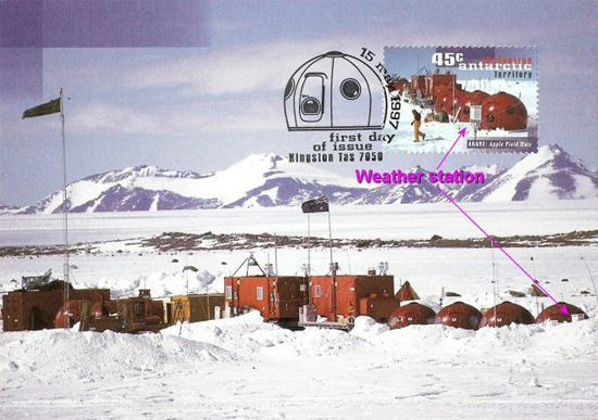
"Regarding that rapid warming of 2C in the last 50 years, just remember that most weather stations in the Antarctic are near humanity, and humanity requires warmth to survive. For example [photo, annotated in purplish we assume by Watts]:

....and finished with:
The Antarctic peninsula is the most populated place in Antarctica."
"The Earth’s surface area is about 510 million square kilometres. The Arctic ice extent at it’s [sic] minimum is currently around 3 million square kilometres. So we’re talking about 0.6% of the area."
“I don’t think this apparent record sea ice minimum is of particular significance in our understanding of climate variability and change of Arctic sea ice.”


"We can expect more summers like 2012 as the ice cover continues to thin. The loss of summer sea ice has led to unusual warming of the Arctic atmosphere, that in turn impacts weather patterns in the northern hemisphere, that can result in persistent extreme weather such as droughts, heatwaves and flooding."
The era of procrastination, of half measures, of soothing and baffling expedients, of delays, is coming to its close. In its place we are entering a period of consequences. Winston Churchill, 1936.
Posted by John Mason on Saturday, 22 September, 2012
 |
The Skeptical Science website by Skeptical Science is licensed under a Creative Commons Attribution 3.0 Unported License. |
That was it, verbatim. A bit short, but there we are, left to draw our own conclusions. So what are we to make of it? Was Anthony Watts seriously trying to tell us that the West Antarctic Peninsula suffers from an Urban Heat Island effect because a few hundred scientists hang out down there? The photo he used appeared to show a temporary field camp, something akin to the Everest Base Camp and hardly urban in nature. Whereabouts was it? And what does it have to do with a long-term temperature reconstruction based upon hydrogen isotopes from an ice-core? All very mysterious.
However, following the usual stream of comments (general and unending theme = 'those darned warmistas are at it again'), an important clarification was posted, which we reproduce here in full:
A little geographical research shows the location of this interesting area of East Antarctica:
Thanks to Ian for clearing that one up!
It would be unfair to omit the fact that Antarctic sea-ice extent has been high, impressively so if certain blogs are to be believed. Beware! During the current, about-to-end Southern Hemisphere winter, it peaked at about 19.4 million km2, after a minimum of about 5 million last summer (edited 22/09/12 - thanks to Skywatcher in the comments below for spotting the error). Some people seem easily impressed. The 1979-2000 average maximum is around 18.5 million km2. In the Arctic, the maximum has remained this past 30 years at 13.5 million to 14.8 million km2, but the minimum this year is 3.4 million km2, against a 1979-2000 average of approximately 6.75 million km2. That seems to me a rather more substantial figure. It has involved a meltdown of over ten million square kilometres of sea-ice, leaving just three and a half million behind. (addendum 22/09/12: Tamino has covered the Arctic-Antarctic difference in far more detail here.)
So - back to the Northern Hemisphere, and coincidentally, the declaration of a record Arctic sea-ice extent (August 26th) came in a week where the American Meteorological Society released a statement about climate change on August 27th, in which the concluding remarks sum up the situation as follows:
Watts' take on that?
As Scotty of Star Trek fame would have said - 'Ye cannae change the laws of physics.'