Climate Science Glossary

Term Lookup

Enter a term in the search box to find its definition.

Settings

Use the controls in the far right panel to increase or decrease the number of terms automatically displayed (or to completely turn that feature off).

Term Lookup

Settings


All IPCC definitions taken from Climate Change 2007: The Physical Science Basis. Working Group I Contribution to the Fourth Assessment Report of the Intergovernmental Panel on Climate Change, Annex I, Glossary, pp. 941-954. Cambridge University Press.

Home Arguments Software Resources Comments The Consensus Project Translations About Support

Bluesky Facebook LinkedIn Mastodon MeWe

Twitter YouTube RSS Posts RSS Comments Email Subscribe


Climate's changed before
It's the sun
It's not bad
There is no consensus
It's cooling
Models are unreliable
Temp record is unreliable
Animals and plants can adapt
It hasn't warmed since 1998
Antarctica is gaining ice
View All Arguments...


Username
Password
New? Register here
Forgot your password?

Latest Posts

Archives

On the Question of Diminishing Arctic Ice Extent

Posted on 1 June 2010 by muoncounter

Guest post by muoncounter

How there can still be honest disagreement over whether a large body of ice is shrinking or increasing in areal extent over the long term is really quite remarkable.  Since the  reports don’t seem sufficiently convincing, let’s look at the question analytically. In the NOAA’s October, 2009 update to the Sea Ice Cover section of the “Arctic Report Card,” Figure S2 (reproduced below) shows the percentage change in the annual minimum (September) and maximum (March).

This graph is presented as percentage difference in ice extent (area in millions of sq km), relative to the mean for the period (1979-2009).  Both the maximum and minimum are shown with a linear fit; by the slopes of these lines, we see that the sea ice minimum is decreasing faster than the sea ice maximum.  Hence we expect the discrepancy between min and max to increase.

This change in areal extent is accompanied by a systematic change in ice thickness, resulting in an overall decrease in ice volume, as demonstrated in NOAA’s Figure S4 below.

The text accompanying this figure draws a distinction between “multi-year” ice and “first-year” ice, noting that it is the multi-year ice that is thinning.  NOAA’s conclusion is self-evident:  “These changes have resulted in seasonal ice becoming the dominant Arctic sea ice type, both in terms of area coverage and of volume” (Sea Ice Cover, cited above).

These data warrant a closer look.   Additional Arctic sea ice data was merged with the 1979-2009 data used above, allowing a more robust reconstruction of the ice extent, as shown in the graph below.
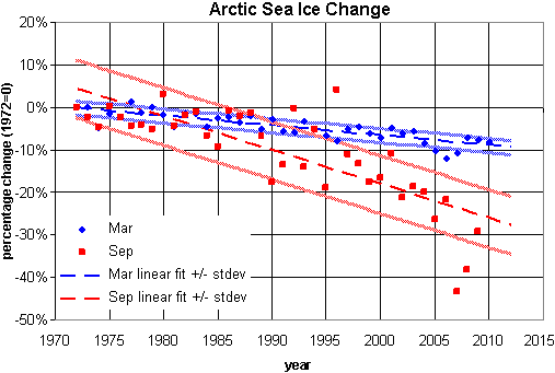
In this graph, areal extent is converted to percentage change from the starting value (areal extent in 1972).  Note that the September minimum ice extent (red) has a steeper slope than the March ice extent maximum (blue).  Each is shown with bands at +/- 1 standard deviation.

Aside from the noisy September data, there are two problems with this graph: 

  1. The two trendlines cross in 1980 (suggesting rather nonsensically that in years prior, the minimum ice extent was greater than the maximum).
  2. The two trends do not statistically clear one another (to one standard deviation) until 1995, more than halfway into the time series.

I suggest that presenting these data as functions of temperature, rather than time, may resolve these problems.

For temperature data, winter sea surface temperature (SST) anomalies recorded at the Pribiloff Islands were smoothed (using a 15 year moving average), producing the graph shown below.  This dataset ends in 2008.
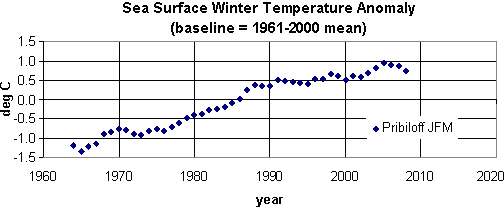
Note:  Additional Arctic summer time series data are available, but those were not analyzed here.  I’ll save that for another day.

In the following plots, the sea ice minima and maxima for the periods of 1972-2008 are shown as functions of this SST anomaly.  In each case, the functional fits, with bands at +/- 1 standard deviation, are clearly nonlinear.
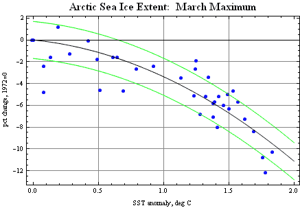
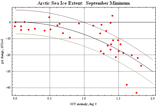
With y representing the percentage change in ice extent and x representing the SST, the function used were:
March maximum, y = -1.196 – 2.186 x2 ;
September minimum, y = 0.253 – 7.620 x2.

Using the 2008 value of the SST in this time series (1.62 deg C), the derivative of these functions provides rates of change in % per degree:
September minimum -0.247 (-24.7% / degree);
March maximum -8.3% / degree. 

Thus not only do we expect the annual loss of sea ice to accelerate, we expect the discrepancy between sea ice minimum and sea ice maximum to continue increasing – at least until the sea ice minimum reaches zero.  Further, because these temperature data are from the winter months, it may be reasonable to conclude that even a few cold winters just aren’t enough to compensate for the overall warming-induced ice loss.

0 0

Printable Version  |  Link to this page

Comments

Prev  1  2  

Comments 51 to 87 out of 87:

  1. muoncounter, thanks for the comments about the PIPS model. However, I have to disagree about this: "I also stumbled across a very smug group of denialists actually placing bets on monthly sea ice extent. Digression: I happened to be watching images of brown pelicans getting much browner at the time and wondered whether these same folks would bet on bird deaths or when oil reaches Pensacola, etc." There are many others who like to bet (formally or informally) on sea ice and other aspects of climate -- e.g., the obvious non-"denialists" at Stoat. Betting on stuff that's emblematic of potentially serious climate change might seem a bit macabre but I don't think it's worth giving people a hard time about.
    0 0
  2. Ned, "I don't think it's worth giving people a hard time about" OK, you caught me on my high horse. Must have been the heat: 93F here.
    0 0
  3. This article is relevant and interesting regarding the difficulties in being able to accurately measure polar ice. If the work is at the stage indicated by the research carried out by this student then reliable, thus useful data is still some way off. Measuring Antarctic snow levels http://www.theage.com.au/national/love-of-science-in-a-cold-climate-20100605-xly2.html
    0 0
  4. johnd, honestly, I completely miss the connection you're trying to make. She is trying to find a way to accurately measure ice thickness from satellites (below 5 cm accuracy), which we know only recently has being tried (2003-04). Could you be more precise instead of genericaly say "useful data is still some way off"? Which data and why?
    0 0
  5. Riccardo at 18:53 PM, you are right, the connection is not really to measuring sea ice extent, the subject of this thread, rather ice volume. With all the different ways various agencies report on trends in polar sea ice, coverage, extent, volume, it becomes confusing. I think ice volume would be the better indicator, however with a range of uncertainty of up to 60% in the various measurements needed to calculate actual volume, such huge uncertainty makes meaningful conclusions difficult to reach. With a new more accurate satellite recently launched, overcoming some of the other factors that contribute to the large uncertainty becomes even more essential for the full potential of the newer technology to be utilised.
    0 0
  6. Fortunately, johnd, there are lots of different ways of measuring the mass balance of ice sheets. The article you linked to is non-technical, so it's not really clear whether the student in question is using radar altimetry or an airborne imaging synthetic aperture radar. But if you're just interested in the bottom line -- is Antarctica gaining or losing mass? -- this can be answered with much less than "60%" uncertainty, using gravity measurements from GRACE:
    0 0
  7. johnd, I don't know where did you take the figure of 60%. Eyeballing from here it looks more likely less than 20% on the thickness and i found it about 30% on the trend. Unfortunately we do not have accurate enough comprehensive thickness measurements of arctic sea ice. This is the reason why we still need to rely on ice extent/area or on models like PIOMAS. The strength of the latter is that it allows the reconstruction of past thickness and volume. In both cases the trend appears to be unambiguous.
    0 0
  8. Ned, I understand that even with GRACE the measurements are subject to errors or uncertainty in excess +/- 50%. If you think otherwise can you perhaps provide a technical reference. Riccardo, your link had nothing about the degree of uncertainty in the calculated values. The indicated trend has nothing to do with uncertainty of the measurements made to calculate the nominal value. The satellite that has been providing data until now is only able to measure sea ice freeboard to an accuracy of +/- 50mm. If the ice is 1 metre thick total, it has a freeboard of only 100mm, so the accuracy range is significant. That is only one part of where the error comes in. Problems with determining density then compound the error, and snow on the ice compounds it again. That was mentioned in that non-technical article I linked to earlier. The latest satellite recently launched supposedly can measure ice freeboard to an accuracy of +/- 10mm, but that still leaves the density and snow problems to overcome.
    0 0
  9. johnd, my link reported the error bars, if you didn't notice, and i added the error in the trend because usually it's what we're interested in.
    0 0
  10. Riccardo at 00:17 AM, the only error bar shown was on right hand graph, and then on the thicker ice. The error should be proportionally larger on the thinner ice. From the error bar that they do show, note that the uncertainty of the submarine data is almost larger than the range of nominal thickness for the entire 30 years of data, and exceeds that of the ICESat data. If included on the thinner ice, or included on the left hand graph then it would be more obvious just how significant the errors are compared to the calculated values, and just how careful one needs to be when drawing conclusions on trends. I do note that throughout the whole climate change debate little is made of the range of uncertainty inherent in any of the data referenced, and little appreciation of such uncertainty by those who debate values and trends as if the values quoted are 100% rock solid. The uncertainties or range of errors are there for an obvious reason. As an analogy, if the value of ice thickness data collected by submarine indicated by the blue line in the right hand graph, instead represented the thickness of sheet steel, say 3mm thick, with the indicated accepted error, over the years any steel mill could have supplied me with steel that varied as the graph indicated and rightfully claim that it is still the same nominal thickness.
    0 0
  11. john, what it's surprising is the shift of the attention as convinience dictates. Indeed, the errors bar relevant to the left figure are not those of submarines data. Having said this, you may have noticed that my comments started saying that determinig ice volume from that satellite images was inappropiate. I didn't see you criticise that. ICEsat determines thickness directly through laser altimetry; there are errors, quite large indeed, yet it's better and gives significant thickness reduction. In the absence of better measurements we all would like to have, a models like PIOMAS are probably better still. As repeatedly said.
    0 0
  12. Riccardo at 05:16 AM, what is surprising is that we seem to have gone the full circle without you realising it. This exchange began with my referring to an article about research being done to improve the accuracy of satellite measurements of ice thickness that you contested the relevance of, yet you sum up above by noting "the absence of better measurements we would all like to have". Technical or non-technical the reference was provided as perhaps being of interest to anyone who appreciates the difficulties in measuring ice, by whatever means! Irrespective of what model is used, they are all still subject to the uncertainty or range of errors inherent in the original measurements that comprise the input data.
    0 0
  13. Here's an interesting presentation by Wieslaw Maslowski of the U.S. naval postgraduate school, shown in a talk at the March "State Of the Arctic" conference. Abstract of talk: Recent reductions of the arctic sea ice cover since the late 1990s provide one of the top examples of warming climate. However, the causes of ice melt and its rate are not fully understood. When compared with the satellite record of summer sea ice extent, simulations from general circulation models (GCMs) participating in the Intergovernmental Panel for Climate Change Fourth Assessment Report are too conservative in their representation of ice melt in the Arctic Ocean. In addition, ice thickness and volume estimates from submarines and satellites as well as from some models suggest that the trend of arctic ice extent decline may not reflect the more rapid rate of ice volume melt. The inability of climate models to reproduce the recent warming and ice melt in the Arctic diminishes their accuracy of future climate predictions. A more realistic regional model representation of the Arctic Ocean and its sea ice indicates an accelerated thinning trend during the last decade. The model skill is evaluated against ice thickness data gathered during the last three decades. It appears that removal of ice from the shelves in the western Arctic for prolonged time acts to increase oceanic heat content in the upper ocean year around, which in turn has a significant impact on sea ice cover. Warm water advection from the adjacent shelves exerts a thermodynamic forcing of sea ice through the under-ice ablation and the lateral melt downstream at marginal ice zones. However, the absolute magnitude and long term variability of the upper ocean heat storage and fluxes are not well known from observations and are typically poorly represented in models. We hypothesize that the excess oceanic heat that has accumulated during recent summers due to increased solar insolation and oceanic heat convergence is a critical initial factor in reducing ice concentration and thickness in the western Arctic Ocean before the melt season and onwards the following year. The modeled thinning trend is robust which lends credence to the postulation that the Arctic not only might, but is likely to be almost ice-free during the summer in the near future. The accompanying presentation is a smorgasbord of visualizations. Advancements and Limitations in Understanding and Predicting Arctic Climate Change (pdf)
    0 0
  14. johnd writes: Ned, I understand that even with GRACE the measurements are subject to errors or uncertainty in excess +/- 50%. Plus or minus 50% of what? If we're going to be quantitative, let's be as precise as possible, please.
    0 0
  15. Ned at 09:27 AM on 7 June, 2010, surely it is obvious, the range of uncertainty always refers to the value it is attached to. Perhaps this information from NASA helps bring some understanding. Quoting from the article:- "The researchers found Antarctica's ice sheet decreased by 152 (plus or minus 80) cubic kilometers of ice annually between April 2002 and August 2005." Plus or minus 80 against a nominal value of 152 is 52.63% to be precise. In other words, all that can be said with any confidence is that the ice sheet decreased by something ranging from 72 to 232 cubic kilometers of ice annually between April 2002 and August 2005, and if you were buying that ice and paid to receive 152 cubic kilometres, the seller could deliver 72 cubic kilometres and there would be absolutely nothing you could do about it. The researchers found Antarctica's ice sheet decreased by 152 (plus or minus 80) cubic kilometers of ice annually between April 2002 and August 2005.
    0 0
  16. I suspect that what Ned was getting at, johnd, is that uncertainty is centered about the mean. Uncertainty does not change our best estimate of the mean, but only our confidence in that best estimate. What is actually the only relevant point is that uncertainty does not change our best estimate of the trend of the mean across time, but only our confidence in that best estimate of the trend. A sufficiently long time of observations reduces the uncertainty.
    0 0
  17. I may have missed it, but looking through all the comments I can't find a link to the NSIDC Arctic Sea Ice News and Analysis page at http://nsidc.org/arcticseaicenews/. The NSIDC graph on the right hand side, updated daily, is interesting to watch, especially this year, when the melt started so late. Now, if the sea ice extent diminishes at its current rate, it could well shrink below that of 2007.
    0 0
  18. johnd writes: surely it is obvious, the range of uncertainty always refers to the value it is attached to. Again, it's necessary to be careful. It's now clear that your "uncertainty in excess of plus or minus 50%" refers to 50% of the estimated change in mass. You calculate that from the article's "152 (plus or minus 80)" and sure enough, 80 is slightly more than 50% of 152. So, let's say GRACE estimates a loss of 2500 km3 of ice from Antarctica over the next decade. What is the uncertainty around that? Is it 50% of the 2500? Is it 50% of 152? Or something else? Tom Dayton makes good points as well. But I want to start with something very basic, please.
    0 0
  19. Tom Dayton at 09:59 AM, if over time the uncertainty reduces then perhaps the range of uncertainty will be reduced, but the ranges are there for good and solid reasons and it should not be forgotten how they actually relate to the mean. The uncertainties are generally inbuilt and relate to the resolution available from the technology utilised, but also relate to the range that the raw data falls within. For a mean of 152 to be established, some of the raw data gathered would have given values equivalent to 72, and some 232, with most of it all over the place, perhaps none at all being 152 or even close. Even with sophisticated satellite measuring equipment we are still not far advanced from the equivalent of measuring the diameter of a human hair with a wooden ruler, in a manner of speaking. The climate change debate may be different to the commercial world where there is a high degree of awareness about tolerances and the implications when anything subject to meeting specifications will be measured by a number of different parties under supposedly standardised conditions, but the limitations should not be overlooked.
    0 0
  20. Another thought experiment, johnd. Suppose global warming suddenly slowed dramatically, and GRACE estimated a decline in mass of only 1 kg next year. Does the "uncertainty of 50%" mean that we know that the actual change in mass was somewhere between 0.5 and 1.5 kg across all of Antarctica?
    0 0
  21. Ned at 10:20 AM on 7 June, 2010, it is the responsibility of whoever provides the data to make known the tolerances that apply to their measurements. It is not something that is always obvious in matters relating to climate change, often considerable digging is required. If always made obvious, the problem that would then "cloud" the debate is that if the range of uncertainty was attached to all data the trends that are so vital to draw conclusions from would often then appear insignificant or non-existent and confuse most people.
    0 0
  22. johnd writes: it is the responsibility of whoever provides the data to make known the tolerances that apply to their measurements. Ah, but the statement "even with GRACE the measurements are subject to errors or uncertainty in excess +/- 50%" was yours, was it not? I'm trying to get at what you mean by that statement.
    0 0
  23. Ned at 10:40 AM on 7 June, 2010, given that each year there is a period where the mass not only slows the decline but actually increases, there is obviously is a point where a 1Kg decline does actually occur. Perhaps you should ask those who process the data how they handle the range of uncertainty at that exact point. :-)
    0 0
  24. johnd writes: Perhaps you should ask those who process the data how they handle the range of uncertainty at that exact point. I suspect her answer would not be that the uncertainty is 50% of the measured change. That's why I'm asking you, not her. I have observed that a lot of your comments at this site involve emphasizing the high degree of uncertainty in this or that measurement or conclusion, regardless of the subject. Paying close attention to uncertainty is a good thing ... but there's a difference between paying close attention to uncertainty and using the existence of uncertainty as an all-purpose justification for avoiding the responsibility of drawing conclusions.
    0 0
  25. Ned at 11:10 AM, uncertainty has nothing to do with avoiding drawing conclusions, but rather accepting the responsibilities of the physical limitations of being able to measure anything accurately. Those who ignore them are avoiding the reality that perhaps what they attempt to quantify may be far from what they desire, or even preventing them from reaching any conclusion at all, not good if you desperately want to make a case. To answer your thought game, the 1Kg would be 1Kg +/- 80 cubic kilometres as tolerances are generally expressed in absolute terms depending on how they are derived. As I stated earlier the errors were in excess of 50% and this certainly is. That doesn't exactly make your 1Kg very meaningful, or the thought game. Perhaps you would like to offer a different value?
    0 0
  26. Thank you for humoring me, johnd. Let's just continue a little. I think we're approaching some clarity here. By "uncertainty of 50%" it seems you meant "uncertainty of 80 km3, which in 2002-2005 was about 50% of the absolute value of the annual trend". Thus, if for another period the estimate of the change in ice mass was near zero, you would still expect the uncertainty to be plus or minus 80 km3, but centered around 0. Now, presumably, this error model suggests that if the estimated rate of ice loss in 2006-2009 were higher than in 2002-2005, the uncertainty would be less than 50%. Next, we'll want to incorporate Tom Dayton's point that "a sufficiently long time of observations reduces the uncertainty." The 80 km3 figure was based on ~3 years of data. Presumably, the uncertainty will be lower as more years' worth of data are acquired, right?
    0 0
  27. NSIDC posts their monthly update, here. In this post they mention PIOMAS which appears to have fallen off a cliff. PIOMAS uses observations and numerical models to make ongoing estimates of changes in sea ice volume. According to PIOMAS, the average Arctic sea ice volume for May 2010 was 19,000 cubic kilometers (4,600 cubic miles), the lowest May volume over the 1979 to 2010 period. May 2010 volume was 42% below the 1979 maximum, and 32% below the 1979 to 2009 May average. The May 2010 ice volume is also 2.5 standard deviations below the 1979 to 2010 linear trend for May (–3,400 cubic kilometers, or -816 cubic miles, per decade). Cold Canary.
    0 0
  28. Not sure why this hasn’t occurred to me before now. Decline in ice extent looks linear to some, yet appears parabolically accelerating (concave downwards) to others. Unfortunately, neither curve shape is particularly realistic for the long term. A logistic curve provides a far more acceptable shape. With time on the horizontal axis, a logistic model makes physical sense: There must be both a maximum ice extent (we’re speaking of an interglacial period here) and there is an obvious minimum ice extent. The rate of change of a logistic is, by definition, a maximum somewhere in the middle (at the inflection point). As we approach either the lower or upper horizontal asymptote, the rate of change decreases to 0. All we need do is flip the curve around so that ice extent decreases over the long term. Since these images are not always showing up as embedded, here is the link. The data points shown are a composite of 1972-2009, as before. However, I also found a 2007 model study by Meier, Stroeve and Fetterer, which extends the time series for the September minima backwards to 1953. Those model points are included in this new graph, shown as open squares at the left. As before, each curve is accompanied with +/- 1 standard deviation. This curve shape is strongly suggested in a 2006 model study, especially Figure 1a and again in Stroeve, et al, 2007. Defining the logistic curve is straightforward: If we let y = A/(1 + B ek(t - Tm)), there are four parameters to vary: A sets the upper asymptote (max historic ice extent), Tm is the time of maximum slope. B and k determine the shape of the graph. The good news: When the slope of this curve type reaches its maximum negative rate of change (perhaps 2007 for the September data set??), it starts slowing down.
    0 0
  29. Interesting article relevant to this discussion : Arctic Sea Ice at Lowest Point in Thousands of Years
    0 0
  30. muoncounter, thanks for the comment and especially the links. Bob Grumbine also uses a logistic model to analyze trends in Arctic sea ice. I am dubious about this. First of all, I don't think that any single simplistic empirical model will ultimately provide a good representation of the time evolution of sea ice, because I think we're likely to go through a series of different regime shifts over time in which different constraints become more or less important and thus different time periods would follow different models. (Sorry to be so vague; I'll try to take some time later to figure out how to express my thoughts on this better). As an indicator of this, take a look at the residuals of your Sept. model. There are a long series of points in the 1970s that have negative residuals, and a long series before 2007 (1996-2006?) with positive residuals. With regard to the March curve, we're still very much on the "shoulder" of the logistic curve, and even in the absence of any physical understanding that would seem to suggest that small errors in the model would lead to large errors in predictions further down the line (though in the figure you wisely don't attempt to extend the curve too far). But eventually the March curve would approach 0, and that just doesn't seem physically realistic -- even with a very large warming I don't see how we could produce an ice-free Arctic Ocean in winter, given the absence of insolation, unless there's an immense increase in the poleward heat flux. Anyway, sorry if this all sounds negative ... that's not my intent!
    0 0
  31. Ned #80, Negative?? Why worry, this is skeptical science, after all. "I don't think that any single simplistic empirical model will ultimately provide a good representation of the time evolution of sea ice, because I think we're likely to go through a series of different regime shifts over time" Agreed; I'm more interested in shapes of curves and rates of change than prediction. And one can learn a lot by observing (and trying to explain) where, when and why a dataset systematically departs from a simple curve. For an example, what will happen to the ice melt regime when the summer melt season consistently opens a "Northwest Passage" for more months of the year? I can't imagine that wouldn't drastically alter polar oceanic circulation, with huge consequences. "eventually the March curve would approach 0, and that just doesn't seem physically realistic" Logistic models don't have to go to zero. There is a more general version of the curve with both nonzero upper and lower asymptotes. For example, shown below (link in case it doesn't show) is such a curve applied to 50 years of atmospheric CO2 data. The curve goes flat on the left to match the general shape of ice core CO2 (Law Dome in particular), which shows a more or less constant level of 280-300 ppm for several hundred years back. More good news, the upper limit for this graph is only 450 ppm (but that's to be seen, no?)
    0 0
  32. muoncounter writes: Logistic models don't have to go to zero. Ah, yes, you're right of course. I'm not sure why I assumed you were extrapolating March sea ice to 0. Sorry! Comment in haste, repent at leisure is my motto.
    0 0
  33. I posted this over at Websites to monitor the Arctic Sea Ice, but I repost it here so more potentially interested people might read it: If it's OK I'd like to point out that I have tentatively started a blog that is dedicated to assembling news and data concerning the Arctic sea ice, as I kind of miss one central place where everyone who is interested can discuss what's going on. The blog is HERE and I'd appreciate it if people would come over and spread their knowledge, 'cause I'm lacking in that department. :-)
    0 0
  34. From a NRL 2009 issue we can learn what people managing PIPS think about ice volume: "Evaluation of PIPS 2.0 forecasts from 2000 to 2008 reveal a slow overall decrease in Arctic ice with a minimum during the summers of 2007 and 2008. This decrease is occurring both in area of ice coverage and total ice volume. For example, in the central Arctic, ice exhibits a seasonal cycle with minimum volume in September. PIPS 2.0 indicates that this annual minimum in ice volume has undergone a 35% loss from 0.59 × 10^9 m3 in 2000 to a low of 0.38 × 10^9 m3 in 2008 (Table 1). A similar decreasing pattern also occurs in both the western and eastern Arctic regions during the same time period." I hope this will end all the naive analisys of nice color images a la Goddard.
    0 0
  35. For those sweating "ice weather" for this year, here's a handy summary of predictions from 14 persons/organizations considered expert in the field: September Sea Ice Outlook: June Report (There are actually 16 predictions but one of 'em is an extreme outlier in the "melted" direction and does not seem credible, the other is the result of a discussion among laypersons moderated by the Pacific Science Center in Seattle)
    0 0
  36. In images now available from Canadian and Danish sources, the beginnings of an ice free Northwest Passage can be seen. 7/22/2010 Denmark DMI/COI 8/3/2010 Canada 7/22/2010 Book your passage now!
    0 0
  37. As the commercials say, "Here we go". High-tonnage tanker through Northeast passage
    0 0

Prev  1  2  

You need to be logged in to post a comment. Login via the left margin or if you're new, register here.


The Consensus Project Website

THE ESCALATOR

(free to republish)


© Copyright 2024 John Cook
Home | Translations | About Us | Privacy | Contact Us