Visual depictions of Sea Level Rise
Posted on 3 March 2010 by Peter Hogarth
Guest post by Peter Hogarth
Even many critics would agree that global sea levels are currently rising, regardless of recent scrutiny and revision of estimates of predicted sea level rise. As pointed out previously, predicting sea level rise is tough. The National Oceanic and Atmospheric Administration (NOAA) puts it neatly, “To make predictions, we need knowledge. To gain knowledge we need observations”. However a recent claim disputes that current sea levels are rising significantly. Is it possible to verify or falsify this statement by looking at observations and data from the scientific community concerned with measuring sea level?
The answer is yes. Measuring sea level is now a multidisciplinary effort involving integration of observations from several global networks of hundreds of tidal stations, calibrated with vertical reference data from nearby GPS (Global Positioning System, which now use the American GPS, Russian GLONASS and European Galileo constellations of satellites) or DORIS (Doppler Orbitography Integrated by Satellite) stations, and data from several independent satellite based radar altimeters (recently Jason I, Jason II, and Envisat) which give complete global coverage, data on sea temperature and pressure from the ARGO floating sensors (which give information on temperature and salinity related variations in Oceanic volume), and most recently data from the satellite based gravity sensor GRACE (Gravity Recovery And Climate Experiment), which can give direct measurements of changes in mass of oceanic and land based water.
A 2009 review by Merrifield et al of the GLOSS (Global Sea Level Observing System) gives some indication of the large number and variety of organizations and workers involved. These measurements are complementary as well as providing independent cross validation checks on any individual data set, and many teams independently process raw observations to derive sea level data. This has enormously improved our knowledge of estimated sea level rise at global and regional level over the past 20 years, with continual refinements of estimates, as well as reductions in uncertainties from the centimetric level to sub mm level.
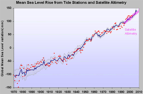
What are the conclusions from these efforts? Recent reviews (Cazenave et al 2009, Cazenave and Llovel 2010) show that the most up to date estimates of mean rate of sea level rise for the 20th century are converging on around 1.7 to 1.8mm/year, with uncertainties of around 0.2 to 0.3mm. (Ablain 2009, Church 2008, Engelhart 2009, Jevrejeva 2008, Leulette 2009, Merrifield 2009, Woppelmann 2009). The small differences between reported figures are mainly due to the different Glacial-Isostatic Adjustment (GIA) model or GPS based corrections that are used for the tidal stations, and extrapolating current knowledge of these vertical velocity corrections backwards to before the absolute GPS corrected data was available.

Figure 1: Global corrected tidal station data (Church 2006 updated to 2009-dark blue, and Jevrejeva 2008- red)
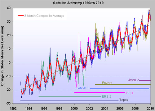
Most recently, corrected tidal station data from the satellite altimeter period of 1993 to 2010 is in good agreement (within the error budget) with the satellite altimeter data, which gives 3.3mm/year ±0.4mm once GIA corrections are added. These values are considered “robust”. The overall message is clear. Sea levels are rising.

Figure 2: Data from all satellite altimeters and 3 month composite average. The seasonal variations have been retained (trend 2.83mm/year, GIA correction would add another 0.2 to 0.5mm/yr)
Both tidal station data and altimeter data show decadal and shorter term variations in the rate of rise, but there is a significant weight of evidence of a recent acceleration in rate of sea level rise towards the end of the last century (Jevrejeva 2008, Merrifield 2009, Vermeer 2009), whilst the “slowing down” reported by some observers (around 2008) has proved short lived (judging from 2009/2010 data).
It has also now become possible to attempt to “close” the sea level budget, which has components of reported thermal expansion of the volume of water due to increase in accumulated heat energy, and also an increased component from melting ice from land based sources. Again refinements and corrections of recent datasets from GRACE (with GPS) and ARGO resolve previous and relatively recent difficulties, so that the sum of these climate-related contributions (2.85 ± 0.35 mm per year) is now comparable with the altimetry-based sea level rise (3.3 ± 0.4 mm per year) over the 1993 to 2007 period (Cazenave 2010, reporting a consensus of the Ocean Observing Community).
Using these datasets it is estimated that around 30% of the observed rate of rise over the satellite altimeter time period is due to ocean thermal expansion and 55% results from accumulated melting land ice. There is evidence that the land ice melt contribution has increased significantly over the past five years.
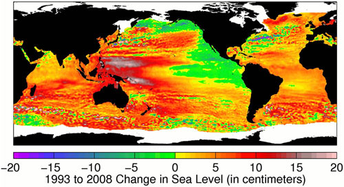
The Satellite altimetry data is also truly global in extent, allowing estimates of recent sea level rise to be made for open ocean or areas not served by calibrated tide gauges. The distribution of higher than average historical rises (up to 10mm/year) in sea level reported from many tidal stations, whilst other tidal stations consistently reported reductions in sea level, is verified by the altimetry data, but a much more complete and complex picture emerges, of dynamic changes of sea level and local regions of high and low average sea level rise.

Figure 3: Sea level changes between 1993 and 2008 from TOPEX/Poseidon, Jason-1 and Jason-2 satellite altimeters. The oceans are colour coded for changes in mean sea level. Yellow and red regions show rising sea level, while green and blue regions show falling sea level. White regions are missing data during parts of the year. On average the global sea level is rising, but complex regional variations are superimposed on this. Credit: Data products from Ssalto/Duacs, distributed by Aviso, with support from CNES.
The correlation with variations in Sea Surface Temperature and also with PDO, NAO, El Nino and La Nina events is marked, and the influence of Westerly equatorial ocean currents and other currents and prevailing wind systems is also apparent. At a glance this confirms and explains for example the discrepancy between data from tidal stations on the Western and Eastern Coast of the United States and the fact that even GIA corrected data from Alaska shows local reductions in sea level over much of the record. This answers a point many observers make such as "why has my local sea level not shown an increase?"
The dynamic nature of sea level variations can be best visualised by time sequence animations of the Topex, Jason I and Jason II global data sets (NOAA Laboratory for Satellite Altimetry).
The following shows 3-D sea level variations with colours representing sea surface temperatures during the El Nino over 1997 to 1998 (NASA/Goddard Space Flight Center Scientific Visualization Studio).
These yearly rates of sea level rise may appear small compared with daily tidal variations of up to 8m (eg - Bay of Fundy) or even the average wave height in open waters(!). However, while the steady and gradually accelerating increase since pre-industrial times of around 30cm or a foot may appear manageable, if the recent trend of accelerating mass loss from Greenland and Antarctic Ice caps, as well as the world's glaciers continues, then the potential sea level rises will have significant impact on humanity. The weight of peer-reviewed evidence for this acceleration in sea level rise is robust.


 Arguments


Once the contribution from ice sheets are taken into account, two entirely independent analyses (one using past sea level behaviour, the other using ice sheet dynamics) find the expected sea level rise by 2100 to be between 80 cm to 2 metres (Vermeer 2009, Pfeffer 2008). . This sea level rise will be more than inconvenient to many millions of people.
You make a good point that sea level rise has changed dramatically in the past. In fact, the past tells us volumes about how sea level responds to temperature. What it tells us is that ice sheets are very sensitive to changes in temperature. Consider that our lower emission scenarios predict a warming of around 1 to 2°C. This is approximately the same as the temperatures during the last interglacial, around 125,000 years ago. At this same time, sea levels were at least 6 metres higher than current levels.
In other words, while we expect sea levels to rise 80cm to 2 metres by 2100, sea level rise won't stop there. They will continue to rise and at our current emission trajectory, we expect sea level rise of at least 6 metres. There is uncertainty over how long this will take - likely centuries. I imagine future generations will not look kindly at the late 20th Century/early 21st Century generations who ignored these multiple lines of peer-reviewed evidence for dramatic sea level rise.