Subscribe in a reader


Username
Password
Keep me logged in
New? Register here


It's the sun
Climate's changed before
There is no consensus
Surface temp is unreliable
It's cooling
Models are unreliable
Ice age predicted in the 70s
Al Gore got it wrong
We're heading into an ice age
CO2 lags temperature
View All Arguments...


Latest Posts


Thursday, 15 May, 2008

April update on global cooling 2008

Simon Donner makes a valid criticism of the climate blog ritual of scrutinising monthly temperature data. If recent events tell us anything, it's not to draw conclusions about long term climate trends based on short term temperature fluctuations. So is it really instructive to scrutinise monthly records and attempt to infer meaning in data dominated by weather noise? Maybe not. But it is fun.

GISSTemp just updated their land-ocean temperature index (a few days later than usual). Figure 1 shows updated global temperature anomaly since January 2007, plotted alongside the Southern Oscillation Index (a measure of ENSO activity).


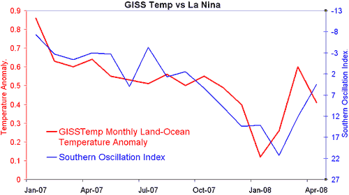
Figure 1: Global temperature anomaly> (red line - NASA GISS) compared to Southern Oscillation Index (blue line - Australian Bureau of Meteorology). The SOI axis is inverted for readability as high positive SOI values correspond to strong La Nina conditions.

The SOI index continues it's trend from last month so we can say with more confidence that La Nina is subsiding. Also of interest is March 2008 which GISS adjusted from 0.67°C to 0.60°C. The reason for the adjustment is apparent when viewing a global map of March temperature anomaly. Previously, the whole southern half of Africa was missing from the GISS record. Much of that data has been filled in, showing cool conditions.


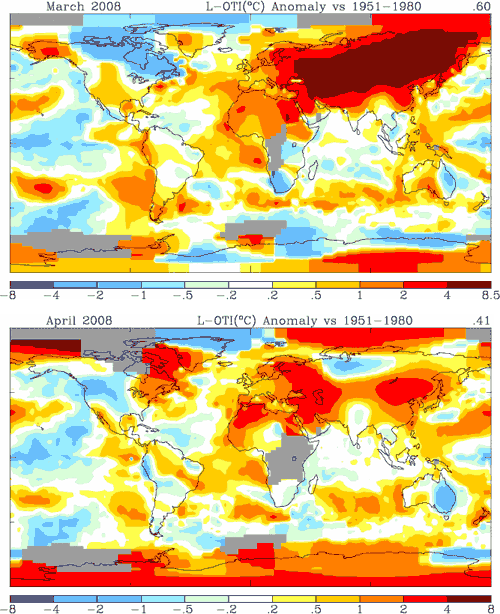
Figure 2: Map of temperature anomaly for March and April 2008.

April 2008 is lower than March - largely due to dramatic cooling across Russia. Much of the continent suffering unusually hot weather conditions in March. As La Nina continues to decline (and in fact the SOI may even switch to negative conditions next month), I would expect global temperatures to follow.

Of course pesky weather and other factors may come into play. The northern Pacific is cooling with the PDO switching to a cool phase. Plus a volcano erupted in Chile last week. When Mount Pinutabo erupted in 1991, it emitted 20 million tonnes of sulfur dioxide, lowering global temperatures significantly for several years. However, the Chaiten volcano has only emitted an estimated few thousand tons of sulfur dioxide. According to Rutgers University professor and volcano boffin, Alan Robock, "a volcano must spew at least 1 million tons of sulfur dioxide into the stratosphere to have a global effect on climate." It will be interesting to see May's data, particularly the spatial temperature changes around South America. The climate blog ritual rolls on...

Posted by John Cook at 20:26 PM

Comments

  1. I guess we can start looking at the next El Nino that were signalled by the recent eruptions in Chile.
  2. From the link: "This exact same phenomenon plagues the coverage of climate change. We're now analyzing the release of each month's global temperature data as if one month could provide some statistically meaningful insight on the long-term picture."

    Indeed. There seems to be a fanatical frenzied obsession now among blogs, op-eds, and contrarians regarding short-term data. They are eager to exploit the recent la Nina for everything it's worth. Much of the general public doesn't seem particularly astute when it comes to general statistics and year-to-year and month-to-month volatility. Some are easily fooled by graphs of temperature trends using selective data and baselines.

    Part of this might have to do with the increased likelihood that the U.S. will be passing meaningful (arguably) legislation to control emissions within a year or so, a fear I don't entirely understand.
  3. UnknownfromBulgaria at 23:29 PM on 22 May 2008
    However,there is one thing I'havent understood. What might have caused this significant cooling in Russia in April,compared to march 2008.Can someone pose a suggestion which might explain that.Did some phenomenen like a volcano in Siberia,for example occur in the end of March or in the begining of April ?
  4. UnknownfromBulgaria
    It isn't just Russia, We have had cold weather and snow in the NE U.S. as well this week, first time in a long time for May (but it has happened before). The entire northern hemisphere {with the exception of western europe last I heard} has seen this anomaly. See the PDO post and comments
  5. UnknownfromBulgaria
    I did a quick check on stats for my area to demostrate my point:
    Month Avg.Low Avg.High Record Low Record High

    May 1 38° 61° 20° (1931) 82° (1930)
    May 2 39° 61° 25° (1943) 84° (1942)
    May 22 45° 69° 29° (2002) 88° (1941)

    Today 39° 50°

    Today is fairly representative of the this month, running between 10 and 20 degrees F below normal highs and about 10 below normal lows. What I noticed after posting the data was the dates. I guess I need to check this out some more.
  6. Wondering Aloud at 04:52 AM on 29 May 2008
    Wildly cold would be a good descripyion on May in the Midwest. We had freeze warnings for Memorial day and have only climed very briefly into the 70's this month.
  7. Philippe Chantreau at 17:52 PM on 29 May 2008
    Sorry, WA. Over here, May has seen the Oregon coast reach triple digits, before Phoenix, AR. A first in recorded history.
  8. Wondering Aloud at 04:52 AM on 30 May 2008
    Well Phillippe it could be all the hot air from your recent primary election. It does appear you are the exception, as Montana to Ohio at least have been frigid and we may have some very serious agriculture effects if it doesn't change soon.
  9. Philippe Chantreau at 01:49 AM on 31 May 2008
    And I meant Phoenix,AZ, of course. Hot air is nobody's exclusivity in election times, it qualifies as a well mixed gas. There will always be weather.
  10. Local update - switch from below average to above average:

    Mo.,. u Lo, u Hi, u Precip, Record Lo, Record Hi
    Jun 1, 49°, 72°, 0.14 in, 31° (2001), 88° (1937)
    Jun 2, 49°, 72°, 0.14 in, 34° (1998), 85° (1989)
    Jun 3, 49°, 72°, 0.14 in, 32° (1929), 86° (1978)
    Jun 4, 49°, 72°, 0.14 in, 30° (1926), 86° (1990)
    Jun 5, 50°, 73°, 0.14 in, 34° (1964), 88° (1943)
    Jun 6, 50°, 73°, 0.14 in, 33° (1929), 86° (1973)

    Today, 66°, 88°

    this switch from cooler to warmer occurred a couple days ago, and the forcast for the next few days is like today. Above average but not record setting. Again the record years are of interest.
  11. Actually today will set a record high if the predicted temp is reached. (all temps in F)
  12. Addendum to post 11
    No records set and we are back to temps below to about historic average. WA may have been right on this prediction, at least in the NE U.S.
  13. Well that is a two way street. If Al Gore can use every lightning strike, hurricane, or spring flood as evidence of impending global disaster from climate change, it seems only logical that global warming skeptics can use a month of global cold weather to bolster their position.

Post a Comment

Foul language, trolling, personal attacks or non-relevant links will be deleted.

You need to be logged in to post a comment. Login via the left margin or if you're new, register here.

© John Cook 2008