Does record snowfall disprove global warming?
Posted on 7 March 2010 by John Cook
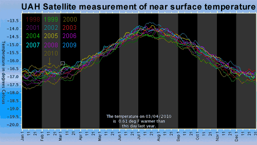
The 2009/2010 winter saw a number of dramatic, record breaking snowstorms. Early February saw two "once in a 100 years" snowstorms hit Philadelphia, now being dubbed "Snowmageddon". Does record snowfall prove that global warming isn't happening? What do observations say? 2009 was the second hottest year on record. January 2010 was the hottest January in the UAH satellite record. Satellites data indicates last month was the second hottest February in the satellite record. Observations tell us that rumours of global warming's death have been greatly exaggerated.

Figure 1: UAH satellite measurement of near surface temperature. January 2010 is the hottest January in the satellite record. February 2010 is the second hottest February in the satellite record. Click on the image for larger version.
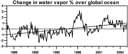
If global warming is still happening, why are some areas experiencing record snowfall events? As climate warms, evaporation from the ocean increases. This results in more water vapour in the air. Globally, atmospheric water vapour has increased by about 5% over the 20th century. Most of the increase has occurred since 1970 (IPCC AR4 3.4.2.1). This is confirmed by satellites that find the total atmospheric moisture content has been increasing since measurements began in 1988 (Santer 2007).

Figure 2: Change in water vapor percentage relative to the 1988 to 2004 period over the global ocean plus linear trend, measured by satellite (IPCC AR4 3.4.2.1).
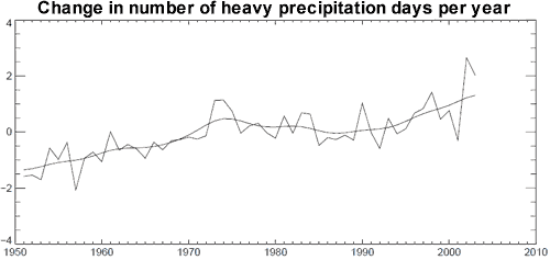
The extra moisture in the air is expected to produce more precipitation, including more extreme precipitation events. Observations bear this out. A study of precipitation trends over the United States found that heavy precipitation events (over 50mm in a day) have increased 20% over the 20th Century (Groisman 2004). Most of this increase occured after 1970. Various analyses of precipitation over the globe have similarly found a widespread increase in heavy precipitation days since 1950 (Alexander 2006, Groisman 2006).

Figure 3: Global number of days per year when precipitation was greater than 10mm per day, expressed as an anomaly from the 1961 tp 1990 reference period (Alexander 2006).
Snowstorms can occur if temperatures are in the range of -10°C to 0°C. Global warming decreases the likeliness of snowstorm conditions in warmer, southern regions. However, in northern, colder regions, temperatures are often too cold for very heavy snow so warming can bring more favourable snowstorm conditions (Kunkel 2008). This is borne out in observations. Over the last century, there has been a downward trend in snowstorms across the lower Midwest, South and West Coast. Conversely, there's been an increase in snowstorms in the upper Midwest East, and Northeast with the overall national trend also upwards (Changnon 2006).
To claim that record snowfall is inconsistent with a warming world betrays a lack of understanding of the link between global warming and extreme precipitation. Global temperatures in the last few months of record snowfall are some of the hottest on record. Warming causes more moisture in the air which leads to more extreme precipitation events. This includes more heavy snowstorms in regions where snowfall conditions are favourable. Far from contradicting global warming, record snowfall is predicted by climate models and consistent with our expectation of more extreme precipitation events.
UPDATE 8 Mar 2010: Based on some of the comments below, a few clarifying points are in order. Global warming cannot be said to cause a specific snowstorm or any extreme weather event for that matter. An appropriate metaphor to explain the difference between weather and climate is the rolling of a die. An extreme precipitation event is like rolling a six. The result is based on random, chaotic processes. However, if you weight the die, this increases the chances of rolling a six. Similarly, global warming increases the chances of extreme precipitation events.
Global warming does not lead to increased snowstorms everywhere. They only increase in colder regions where the temperature still remains below freezing despite warming trends. Snowstorms are currently decreasing in warmer areas. Overall, the total amount of snow cover has shown a long-term decreasing trend.
So to summate, record snowfall neither proves nor disproves global warming. However, the increasing trend in extreme precipitation events is consistent with global warming. And this will lead to increased snowstorms in certain, colder regions.


 Arguments


However, the change in cloud cover has had a cooling effect - it's estimated the radiative forcing from 1850 to 2000 was a cooling of -0.7 W/m2. I couldn't tell you off the top of my head how much of that is estimated from increased water vapor - my understanding is the main contributor to increased cloud cover is increased aerosols in the atmosphere which enhances cloud formation.
Since 2000, several different satellite datasets show very little trend in cloud cover (Loeb 2007a):
There's a more detailed discussion on albedo at The albedo effect and global warming.
It is a little difficult to read so small. I suggest generating the image yourself via http://discover.itsc.uah.edu/amsutemps/ so you can experiment with different years and different altitudes yourself. The UAH webpage also explains the brightness temperature (to some extent anyway).