Climate Science Glossary

Term Lookup

Enter a term in the search box to find its definition.

Settings

Use the controls in the far right panel to increase or decrease the number of terms automatically displayed (or to completely turn that feature off).

Term Lookup

Settings


All IPCC definitions taken from Climate Change 2007: The Physical Science Basis. Working Group I Contribution to the Fourth Assessment Report of the Intergovernmental Panel on Climate Change, Annex I, Glossary, pp. 941-954. Cambridge University Press.

Home Arguments Software Resources Comments The Consensus Project Translations About Support

Bluesky Facebook LinkedIn Mastodon MeWe

Twitter YouTube RSS Posts RSS Comments Email Subscribe


Climate's changed before
It's the sun
It's not bad
There is no consensus
It's cooling
Models are unreliable
Temp record is unreliable
Animals and plants can adapt
It hasn't warmed since 1998
Antarctica is gaining ice
View All Arguments...


Username
Password
New? Register here
Forgot your password?

Latest Posts

Archives

How reliable are CO2 measurements?

What the science says...

Select a level... Basic Intermediate

CO2 levels are measured by hundreds of stations across the globe, all reporting the same trend.

Climate Myth...

CO2 measurements are suspect

"The Keeling curve, which is widely used to show the increase in CO2 emissions, is based on data from the top of Mount Mauna Loa in Hawaii. Mauna Loa is a volcano and it doesn’t seem to me that a volcano is the best place to be taking CO2 measurements" (disinter)

At a glance

Mauna Loa is an active volcano on 'Big Island', the largest of the chain that makes up the state of Hawaii. It does not erupt that often; the last four times at the time of writing (2023) were in 1950, 1975, 1984 and 2022-23. The summit is 4,169 metres (13,679 feet) above sea level.

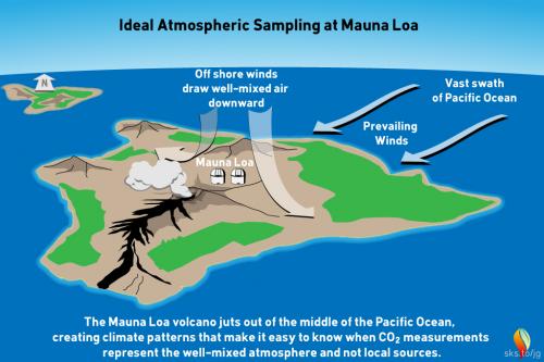
The observatory that takes regular CO2 measurements is situated some 6.4 kilometres (4 miles) from the summit, on the volcano's northern slopes. Here, the prevailing winds are the north-easterly Trades, blowing in clean air off the Pacific Ocean. Hour to hour CO2 levels in this airflow vary by no more than 0.3 parts per million (ppm).

Light southerly winds, bringing air from the volcano, can however occur under very specific weather conditions, normally late at night. Such conditions are readily detectable because unlike the steady 'baseline' readings, CO2 levels suddenly start to jump up and down wildly. These highly erratic CO2 levels are so different from the baseline data that they can easily be filtered out with mathematics. During the 2022-23 eruption, measurements from Mauna Loa Observatory had to be suspended from Nov. 29, 2022 and observations from then until July 4, 2023 were from the Mauna Kea Observatories, approximately 21 miles north of Mauna Loa.

Measurements of CO2 at Mauna Loa commenced in 1958. NOAA’s Earth Science Research Laboratory program also measures CO2 in over 60 locations around the world, taking air samples in flasks. Flask measurements and the Mauna Loa data show excellent agreement. This confirms that occasional detections of volcanic CO2 at Mauna Loa do not affect the final results. The data-filtering process paints a true picture of the situation.

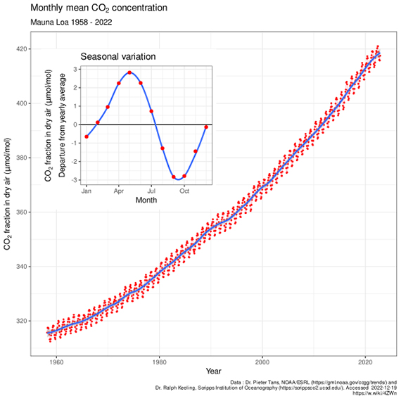
The upward-sloping trend in CO2 concentrations at Mauna Loa is a reflection of human activity. It represents our burning of fossil fuels and other types of carbon emissions. Superimposed on that upward trend is an annual wiggle. The wiggle represents the Fast Carbon Cycle, involving photosynthetic plants in the Northern Hemisphere. That's where most of the planet's landmasses happen to be. Every spring the plants become more active as the growing season starts and CO2 levels start to drop. But autumn comes along, the leaves shrivel and fall and CO2 rises again. It's like the heartbeat of the planet, superimposed on the upwards slope that very definitely represents us.

In conclusion, scientists know all about the volcanic activity at Mauna Loa and the specific conditions in which volcanogenic gas emissions will be and are detected. To suggest otherwise is an example of the misrepresentation often required in order to promote the talking-points of science-denial.

Please use this form to provide feedback about this new "At a glance" section. Read a more technical version below or dig deeper via the tabs above!


Further details

This myth is a classic example of ignoring critically relevant evidence in order to state a conclusion. Misrepresentation is the technical term. The fact that Mauna Loa is a volcano is of course well-known among Earth scientists. Mauna Loa observatory is, however, situated some 6.4 kilometres (4 miles) from the crater, on the volcano's northern slopes. Here, the prevailing north-easterly Trade Winds blow in clean air off the Pacific Ocean. Hourly measured CO2 levels in this airflow vary by no more than 0.3 parts per million (ppm) (fig. 1).

Geography and typical meteorology of the Mauna Loa district

Fig 1: geography and typical meteorology of the Mauna Loa district. Graphic: jg.

Light southerly winds, bringing air from the volcanic vents, can however occur under specific weather-conditions. In such circumstances, a temperature inversion can form over the fumaroles around the summit. The inversion traps volcanic CO2 emissions that drift northwards on that southerly breeze. Such conditions only occur late at night. Their effect is readily detected. Unlike the steady 'baseline' readings from the trade winds, when the southerly wind is blowing, CO2 levels start to fluctuate wildly. These highly erratic CO2 levels differ so much from the baseline measurements that they are easy to spot. They can be removed by mathematical data-filtering. Essentially they represent sporadic outbreaks of 'noise'.

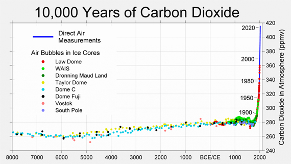
The following graph (fig. 2) shows atmospheric CO2 levels over the last 10,000 years. It includes ice core data for CO2 levels before 1950. For values after 1958, direct measurements from the Mauna Loa Observatory on Hawaii were used.

CO<sub>2</sub> levels over the past 10000 years.

Figure 2: CO2 levels (parts per million) over the past 10,000 years. Source: Berkeley Earth

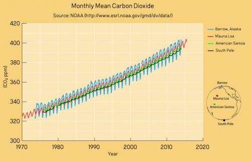
Mauna Loa is often used as an example of rising carbon dioxide levels (fig. 3) because it is the longest, continuous series of directly measured atmospheric CO2, the so-called 'Keeling Curve', that we have. The reason why it's acceptable to use Mauna Loa as a proxy for global CO2 levels is because CO2 mixes well throughout the atmosphere. Consequently, the trend in Mauna Loa CO2 (1.64 ppm per year when this rebuttal was first written in 2010, now 2.69 ppm, July 2022-2023) is statistically indistinguishable from the trend in global CO2 levels (fig. 4). If global CO2 was used in figure 2 above, the resulting "hockey stick" shape would be identical.

The Keeling Curve

Figure 3: The Keeling Curve - monthly mean CO2 concentration data (with the occasional volcanic anomaly filtered out), Mauna Loa Observatory, 1958-2022. Inset shows the annual 'wiggle' caused by seasonal plant-growth and dieback in the Northern Hemisphere. Image licensed under the Creative Commons Attribution-Share Alike 4.0 International licence.

This video is an excellent graphic example of where our data for CO2 levels come from and how the wiggles vary. It shows surface measurements of CO2 varying over different latitudes from 1979 to 2006. The graph is created by Andy Jacobson from NOAA and includes a global map displaying where the measurements are coming from, a comparison of Mauna Loa CO2 to South Pole CO2 and the graph expands at the end to include ice core measurements back to the 19th Century. The key point is that the wiggles are of low magnitude near the equator but are bigger in the north, as might be expected because seasonality is more pronounced at higher latitudes.
CO2 measurements from Mauna Loa

Figure 4: CO2 measurements from Mauna Loa and some other global sampling stations over recent decades. The trends are identical as are the positions of the wiggles that vary in magnitude according to seasonality in the Northern Hemisphere. Data from NASA; graphic by jg.

Satellite data is also consistent with surface measurements. This video shows the global distribution of mid-tropospheric carbon dioxide. The data comes from the Atmospheric Infrared Sounder (AIRS) on the NASA Aqua spacecraft. Superimposed over the global map is a graph of carbon dioxide observed at the Mauna Loa observatory. However CO2 levels are measured, the same trend is observed. Upwards and upwards and upwards.

Last updated on 1 October 2023 by John Mason. View Archives

Printable Version  |  Offline PDF Version  |  Link to this page

Argument Feedback

Please use this form to let us know about suggested updates to this rebuttal.

Further viewing

How is CO2 transported throughout the globe? This is displayed in a CarbonTracker visualisation of global transportation of CO2 through 2008 (more on CarbonTracker).

Comments

Prev  1  2  3  Next

Comments 26 to 50 out of 54:

  1. Johnd, what about other gases? Forgetting C02 for a moment, how about molecular oxygen? Well mixed? Not well mixed?
  2. doug_bostrom at 03:47 AM, I don't have the appropriate data available, perhaps you will have, what is the proportion of atmospheric oxygen that is involved in exchange processes at the surface, or elsewhere for that matter?
  3. Johnd, surely the same processes you hypothesize in your #25 would apply for 02 as well?
  4. doug_bostrom at 05:01 AM, since when has the sequestration and liberation of carbon between the atmosphere and the plants, soil and ocean been returned to being a mere hypothesis. Perhaps the data on what proportion of atmospheric oxygen is involved in similar exchange processes at the surface as CO2 would provide a clue. What does that tell you? The carbon cycle requires CO2 to be sequestered at the very surface of the planet from where it is also liberated. On an annual basis about 200Gt of C is sequestered and 200Gt liberated by processes that occur at the surface. This is out of a total of 750Gt of C present in the air giving an equivalent total turnover time of 3.5 years. If a similarly high proportion of oxygen does turnover within a similar time frame than surely you would agree that heat distribution throughout the atmosphere would also be well mixed, oxygen being such a high proportion of the atmosphere rather than a trace gas?
  5. Johnd, just so we're clear, I understand you to hypothesize that some concentration of C02 is required at the surface in order for the carbon cycle to work? Or are you saying that we -ought- to see a concentration of C02 at the surface -if- there is a carbon cycle? Your original explanation is leaving me scratching my head. What does heat have to do with it?
  6. doug_bostrom at 09:04 AM, please correct me if I am wrong, but the carbon cycle and the sequestration and liberation of CO2 at the earths surface by plants, soil and oceans has been established as a fact, and gone beyond being a hypothesis. Yes or no? With regards to heat, perhaps if you provided some data regarding the processes that you feel surely would apply to the mixing of O2 as they do to CO2, then we will have some basis to examine as to whether they do or not. Given oxygen makes up over 20% of the atmosphere whereas CO2 is a minor trace gas, the means that would have to be applied so that such a minor trace gas will become evenly distributed could be expected to apply to all other elements present in the atmosphere, including heat which always seeks to find equilibrium.
  7. Sorry johnd, you've lost me, I don't understand what you're driving at. I think you're saying that heat has something to do with the carbon cycle, and that unless CO2 is "stirred" up somehow and driven into contact with the surface the carbon cycle can't work? That's what I take from your post here, anyway. I don't know why you're asking me whether I think there's a carbon cycle in operation. Something to do with my question about mixing of other gases, I suppose.
  8. I agree with Doug that johnd needs to be more clear about what specifically he's claiming. Looking back up-thread to johnd's comment here, I see the question "What would be the means that allows CO2 to be well mixed in the atmosphere whereas heat is not." The main answer to that is "residence time." The residence time of CO2 in the atmosphere is very long (on the order of a century or so). The residence time of heat in the atmosphere is very short. (Water vapor, one of the vehicles for heat in the atmosphere, has a residence time of about nine or ten days). Thus, CO2 sticks around long enough to become well-mixed, while heat does not.
  9. johnd, maybe this article by Parazoo et al. has the kind of info you're looking for.
  10. johnd, a less technical and much shorter explanation of CO2's thorough mixing in the atmosphere is given on page 8 of the EPA's Response to Public Comments, Volume 2, in the section "Response 2-8":
    "...turbulent mixing (e.g., through wind and convection) dominates the distribution of gases throughout the atmosphere (below 100 kilometers in altitude). The mixing of substances in a gas or fluid is only dependent on mass when the gas or fluid is perfectly still, or when the pressure of the gas is low enough that there is not much interaction between the molecules. Therefore, all long-lived gases become well-mixed at large distances from their sources or sinks over a period of one to two years...."
    You should also read Response 2-3, regarding lifetime. And some of the nearby Responses.
  11. Tom Dayton at 12:26 PM, thanks for that article, it goes part of the way, the other part being how the variations in CO2 levels interacts with plants that are far closer to CO2 starvation levels than optimum. Do they take in more when the CO2 levels are higher, thus stripping the CO2 out at a higher rate? What the article indicates firstly is that understanding of the processes is still very limited, and that what occurs in the real world of complex and infinitely variable conditions is vastly different, not only from what is at times studied in laboratories under fixed and tightly controlled conditions, but also from some of the rather simplistic generalisations by which many of the AGW subjects are understood by many. This limited understanding of the processes as indicated in the article is perhaps reflected in the differences between some of the modelled and observed data. What is also clear from the article is that the transportation of CO2 at the near surface occurs as part of the weather system which is all about the redistribution of heat energy. What is does not address is the relationship between the belief that CO2 has a residence time of a century or more when the movement of CO2 near the surface satisfies the more immediate requirements of the plants, soil and oceans as both a source and a sink for carbon that requires an equivalent amount of the total atmosphere to be turned over every 3.5 years approximately. Is it that the CO2 high in the atmosphere plays no part in the surface exchanges and is merely the remainder left over? If so does the measurement of this non active participant include or allow for the more variable and highly mobile CO2 at the surface? One wonders whether a statistician studying the utilisation of a swimming pool only counts those passive sunbathers lying on the lawn soaking up the solar energy, using them as a convenient indicator, or does he also count those swimmers who are constantly climbing out of the pool onto the edge and shaking off moisture before diving in again. Getting an accurate count of one group would be easy, nigh impossible for the other in a crowded pool.
  12. johnd, you're now moving on to the topic of CO2 residence time, which has a considerable number of facts and links on a different thread: CO2 has a short residence time. We all can continue this conversation over there, if that's the topic onto which you are moving.
  13. As Tom Dayton suggests, if the question is whether CO2 has a short residence time, that should be discussed in the thread CO2 has a short residence time. If anyone is still uncertain about how consistent CO2 measurements are globally, please go to the World Data Center for Greenhouse Gases, search for CO2 data from various stations, and look at them yourself. Here are some examples of graphs. These data haven't been "normalized" or "fixed" to match each other; they're completely independent data sets. Some are from the polar regions, some from the tropics, some from the northern hemisphere, some from the southern, some from ocean sites, and some from inland sites. 

    [BW 2015-08-22 - link to graphic on imageshack (co2stnsfull.png) no longer valid]

    Here's an enlargement showing 1990 to the present:

    [BW 2015-08-22 - link to graphic on imageshack (co2stnspost1990.png) no longer valid]

    Note how consistent the following are: the actual value, the upward trend, and the seasonal cycle.

    Response:

    [BW 2015-08-22 - embedded graphics deleted as no longer showing valid content (were showing advertisments instead) and were breaking page formatting]

  14. FYI, here are the linear trends in CO2 concentration, 1990-2008, at the stations shown in the above graph:
    Mauna Loa, Hawaii:+1.79 ppmv/year
    Barrow, Alaska:+1.78
    Cape Ferguson, Australia:+1.79
    Halley Bay, Antarctica:+1.78
    Key Biscayne, Florida:+1.78
    Ocean Station M, Norway:+1.78
    Niwot Ridge, Colorado:+1.79
    Of course, the trends are actually increasing exponentially, but over short periods of time they don't diverge much from a linear trend. There are lots of additional stations all over the world that show the same thing. Anyone who still claims that the Keeling Curve is somehow contaminated by proximity to a volcano and unrepresentative of the rest of the world needs to explain why every other non-urban site shows the same pattern.
  15. Okay, one last comment. I wrote "Of course, the trends are actually increasing exponentially, but over short periods of time they don't diverge much from a linear trend." To be precise, the CO2 curves are actually increasing faster than an exponential trend.
  16. This is a response to cruzn246's posting of Beck's CO2 graph on a different thread. CBDunkerson gave an excellent reply on that thread, and a followup. RealClimate has more details in Beck to the Future. Additional perspective is supplied by Eli Rabbett in his posts Amateur Night and then GOGI.
  17. Following Tom D.'s use of the thread-shifting rule, this is a reply to johnd's comment on The Big Picture thread: "Interestingly even when the stations are located in heavily industrialised regions the same seasonal variation still occurs" The magnitude of seasonal variation is hardly the same at all locations. Equatorial and southern hemisphere locations have much smaller seasonal swings. High northern latitude locations have much larger seasonal differences. Heavily industrial areas (like those downwind of power plants) have the largest annual amplitudes -- and tend to have higher annual average concentrations as well. The only thing that is more or less consistent is the rate of increase from year to year, which has crept up from 1 to >2 ppm/year over the 50 years of modern records. Oddly enough, in areas with stringent pollution controls, the annual amplitude may decrease, as reported by Schmidt et al. 2003 in a study of 30 years of CO2 records in Germany: The average seasonal cycle (peak to peak) amplitude has decreased slightly from 13.8 ± 0.6 ppm in the first decade (1972–1981) to 12.8 ± 0.7 ppm in the last two decades (1982–2001). Not too much of a decrease. But it is becoming clear that not only do we add CO2 to the atmosphere by burning fossil fuels, we can modify the annual variation in its concentration. Aren't those what we call anthropogenic effect?
  18. muoncounter at 04:49 AM, the annual variations depend on the degree of difference between the seasons when plant growth slows or becomes dormant and the season when it is most vigorous. In the case of the Schmidt report which I have only read the abstract of, and hence do not know what the actual seasonal conditions were, were they a period of predominately drought or wet years, nor the actual ppm readings, it is impossible to say whether that the natural processes respond more the higher the CO2 concentration, or were responding to changing seasonal conditions due to decadal long natural cycles.
  19. #43: The 2003 Schmidt paper was about 30 years of CO2 data at Schauinsland. Graph from WDCGG (not from the paper) shown below: It appears that the seasonal amplitude has indeed decreased since the late 70s. I don't see any decadal cycles, unless you mean the 4 decades of continuous increase in the annual average.
  20. Probably no one is reading this blog any longer, but the answer should be as follows. 1. The atmosphere thins as we move upward due to gravity. 2. The partial pressure of oxygen is always about 0.21 3. Because there is less gas at high altitudes than low altitudes, there is less TOTAL oxygen at those levels, but it is still 21 percent of total. So if there are 1000 gas molecules at surface, 210 are oxygen. At high altitudes, say the total is 100, then oxygen is 21. 4. From this it follows that CO2 is not evenly distributed on vertical basis in the atmosphere. Consequently, this also applies to temperature given that there are thremoclines in the vertical expanse of the atmosphere. 5. CO2 total is different from one altitude to the next, but CO2 percentage (of total atmospheric gas) should be consistent.
  21. MewCat100 @45, your point (4) lacks clarity. CO2 is approximately evenly distributed with altitude by concentration, as you note in (5). We do not need to reason that out, but can consult actual measurements: C)2 concentration with altitude, Colorado USA: Seasonal variation of CO2 concentration, Russia: CO2 concentration in upper troposphere and stratoshpere: (Click on images for more detailed discussion) However, the small changes of CO2 concentration with altitude are not enough to induce the temperature variations with altitude. They are primarily a function of convection which induces the environmental lapse rate. This is modulated by relative humidity, and by winds which can bring warm or cold air in from other locations. I do not see,however, what this has to do with the question posed in the OP's title.
  22. I see a lot of comments that suggest that CO2 in the ice cores are not accurate because of the fixing of CO2 in the bubbles in the first place happens over decades so that flucuations of less than ~80 aren't recorded and then the interaction of the trapped air with the ice surrounding the bubble. I couldn't find an article that refutes this argument so I thought I'd ask it here. Would anyone care to comment on the accuracy of the ice core data?
  23. Fitz, you can take a look at this. Concentrations in multiple bubbles are averaged, known events used for indexing, there is a variety of ways to ensure the reliability of measurements and extract the best data. It's another one of the things that real scientists have already worked on quite a bit. This paper from the Vostok team has a methodology discussion and a bunch of references, many on methodology: http://cdiac.ornl.gov/trends/co2/vostok.html
  24. Hi Philippe, thanks for those articles! I was interested to read that the air bubbles trapped in the ice represent the composition at the time of snow deposition. I would have thought there would be some movement of air upwards as the snow was compacting. Do you know of any articles that show the comparison of these readings of direct free air and shallow ice core?
  25. Cant lay my hands on the papers, but a lot of work went into finding out when bubbles stopped exchanging with the air. Look up one of the early papers on ice bubble composition and work through reference list.

Prev  1  2  3  Next

Post a Comment

Political, off-topic or ad hominem comments will be deleted. Comments Policy...

You need to be logged in to post a comment. Login via the left margin or if you're new, register here.

Link to this page


The Consensus Project Website

THE ESCALATOR

(free to republish)


© Copyright 2024 John Cook
Home | Translations | About Us | Privacy | Contact Us