Climate Science Glossary

Term Lookup

Enter a term in the search box to find its definition.

Settings

Use the controls in the far right panel to increase or decrease the number of terms automatically displayed (or to completely turn that feature off).

Term Lookup

Settings


All IPCC definitions taken from Climate Change 2007: The Physical Science Basis. Working Group I Contribution to the Fourth Assessment Report of the Intergovernmental Panel on Climate Change, Annex I, Glossary, pp. 941-954. Cambridge University Press.

Home Arguments Software Resources Comments The Consensus Project Translations About Support

Bluesky Facebook LinkedIn Mastodon MeWe

Twitter YouTube RSS Posts RSS Comments Email Subscribe


Climate's changed before
It's the sun
It's not bad
There is no consensus
It's cooling
Models are unreliable
Temp record is unreliable
Animals and plants can adapt
It hasn't warmed since 1998
Antarctica is gaining ice
View All Arguments...


Username
Password
New? Register here
Forgot your password?

Latest Posts

Archives

NASA Satellites Detect Pothole on Road to Higher Seas

Posted on 4 September 2011 by Rob Painting

The following is a re-posted article from the NASA Jet Propulsion Lab

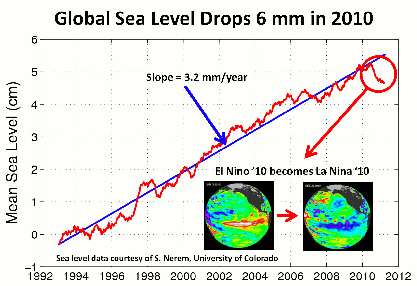
Like mercury in a thermometer, ocean waters expand as they warm. This, along with melting glaciers and ice sheets in Greenland and Antarctica, drives sea levels higher over the long term. For the past 18 years, the U.S./French Jason-1, Jason-2 and Topex/Poseidon spacecraft have been monitoring the gradual rise of the world's ocean in response to global warming.

While the rise of the global ocean has been remarkably steady for most of this time, every once in a while, sea level rise hits a speed bump. This past year, it's been more like a pothole: between last summer and this one, global sea level actually fell by about a quarter of an inch, or half a centimeter.
           Color Bar

Figure 1 - sea level rise 1993-2011 from satellite altimetry.

So what's up with the down seas, and what does it mean? Climate scientist Josh Willis of NASA's Jet Propulsion Laboratory, Pasadena, Calif., says you can blame it on the cycle of El Niño and La Niña in the Pacific.

Willis said that while 2010 began with a sizable El Niño, by year's end, it was replaced by one of the strongest La Niñas in recent memory. This sudden shift in the Pacific changed rainfall patterns all across the globe, bringing massive floods to places like Australia and the Amazon basin, and drought to the southern United States.

Data from the NASA/German Aerospace Center's twin Gravity Recovery and Climate Experiment (Grace) spacecraft provide a clear picture of how this extra rain piled onto the continents in the early parts of 2011. "By detecting where water is on the continents, Grace shows us how water moves around the planet," says Steve Nerem, a sea level scientist at the University of Colorado in Boulder.
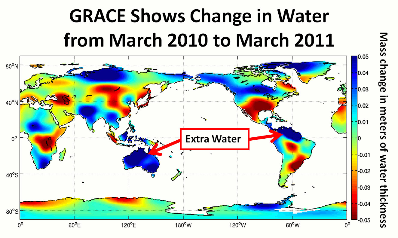
Figure 2 - change in land-based global water storage in the period March 2010-March 2011. Image from NASA JPL. 

So where does all that extra water in Brazil and Australia come from? You guessed it--the ocean. Each year, huge amounts of water are evaporated from the ocean. While most of it falls right back into the ocean as rain, some of it falls over land. "This year, the continents got an extra dose of rain, so much so that global sea levels actually fell over most of the last year," says Carmen Boening, a JPL oceanographer and climate scientist. Boening and colleagues presented these results recently at the annual Grace Science Team Meeting in Austin, Texas.

But for those who might argue that these data show us entering a long-term period of decline in global sea level, Willis cautions that sea level drops such as this one cannot last, and over the long-run, the trend remains solidly up. Water flows downhill, and the extra rain will eventually find its way back to the sea. When it does, global sea level will rise again.

"We're heating up the planet, and in the end that means more sea level rise," says Willis."But El Niño and La Niña always take us on a rainfall rollercoaster, and in years like this they give us sea-level whiplash."

For more information on NASA's sea level monitoring satellites, visit: http://sealevel.jpl.nasa.gov/, http://sealevel.colorado.edu, http://www.csr.utexas.edu/grace/, http://grace.jpl.nasa.gov/.

For further discussion see SkS post: Extreme Flooding In 2010-2011 Lowers Global Sea Level

0 0

Printable Version  |  Link to this page

Comments

Comments 1 to 31:

  1. This NASA article was also posted on WUWT almost as above. The map was omitted allowing it to be presented by their Willis (Eschanbach?) whose great contribution to the debate was to question whether the water had left the oceans for the continents:- "To do that, the above map would have to average a medium blue well up the scale … and it’s obvious from the map that there’s no way that’s happening. So I hate to say this, but their explanation doesn’t … hold water … I suspected I’d find this when I looked, because in the original press release the authors just said: “This year, the continents got an extra dose of rain, so much so that global sea levels actually fell over most of the last year,” says Carmen Boening. When people make claims like that, with no numbers attached, my Urban Legend Detector™ goes off like crazy … and in this case, it was right." So the map's not blue enough so NASA's lying, apparently. Good to see such precise analysis being deployed. And attaching the number "medium blue" to sidestep those Urban Legend Detectors - facinating.
    0 0
  2. Does anybody have any numbers to show the mass balance of missing water from the oceans equating to the net water left on the land masses? Given these massive rainfalls in Australia there is still a portion returned to the oceans by rapid river runoff and the rest absorbed in recharging aquifers, snow & ice etc and increased soil moisture.
    0 0
  3. Re #1: it'd be interesting to see the numbers for that figure, so they could actually be tallied up and the net change in water content of the continents worldwide determined. I know it'd be pretty rough, but considering the extremes of the scale are 50mm of water, and the change in global sea level is ~5mm or so, it might correlate quite well.
    0 0
  4. Two things leap to mind upon reading this: 1. NASA/JPL needs to use a different color scale in that "GRACE Shows..." graphic. In particular, there's an uncomfortable amount of area that's pegged up against the +0.05 dark blue end of the spectrum, with a lesser portion pegged by the -0.05 dark red end. You can't really tell how much extra water we saw in some areas. (I'm assuming that this is true, based on the conclusions of the article.) 2. Is this rainfall-induced drop in SLR another characteristic of our "new normal" state? Is it possible that we've added enough warming to the ocean, in particular, that normal cycles are enhanced enough to produce big enough swings in things like rainfall to cause dips (and surges?) in SLR?
    0 0
  5. Hurrican Irene transferred one heck of a lot of water from the Atlantic to the northeast coast of North America. Does NOAA compute the total amount? The amount absorbed by the land mass? The amount returned to the ocean? How long does it take for hydrological system to return to equilibrium?
    0 0
  6. Lest we forget, SLR is not distributed unifomily throughout the world's ocean systems. A single graph of mean global SLR as shown in Firgure 1 masks one heck of lot of anomalies.
    0 0
  7. This seems very straight-forward. Water temporarily stored on the continent has to come from somewhere and eventually go back somewhere. That somewhere is the oceans; I believe the word cycle as in 'the water cycle' connotes a round trip. Here's an example of the unusual runoff conditions. Summary of Winter 2010-2011. The forecasted runoff for 2011 is 61.8 MAF, 249% of normal. This would be a record inflow runoff, exceeding the previous record inflow of 49.0 MAF in 1997. Jun 2011 data show the same multiples of normal. Isn't it nice to live in times that are 2 1/2x above normal? “Presently, almost three quarters of the automated snow measuring sites in Montana and northern Wyoming still hold considerable snowpack,” ... “In fact, some individual SNOTEL sites, especially the high elevation sites of northern Wyoming, reached this year’s maximum snowpack in the last two days of May.” Anecdotally, I spent a week along the upper Arkansas River in Colorado in early July. While not out of its banks, the river flow was torrential; all the locals could say was 'we've never seen it like this before.' Yet on high ground a mile or so from the river, the ground was parched and fire bans were in place. All the locals there could say was 'we've never seen it like this before.' That's an apt description of the new normal.
    0 0
  8. #1 MA Rodger, #2, critical mass, #3 Bern, etc. GRACE data is divided between land and water areas. Gridded land data by month can be found at ftp://podaac-ftp.jpl.nasa.gov/allData/tellus/L3/land_mass/ in various formats. Data is by anomaly in the equivalent of cm of water at the surface. Even a cursory summation of the data shows a lot more water on the land surface in March 2011 than in March 2010. After summing the entire globe by latitude and correcting for difference in area by latitude, I compute that roughly .41 cm of the .5 cm sea level change can be accounted for by hydrological storage differences between these months. In other words, the JPL/NASA article basically gets it right.
    0 0
  9. Oh and one more thing: does this now mean that the Jason/Poseidon sea level altimetry data is not part of the worldwide scientists' Global Warming Conspiracy/Hoax? Because I'd sure like to identify all the data that's untainted by research grant money.
    0 0
  10. I think you guys are reading too much into this dip. The wiggles in the SLR largely correlate with the ENSO cycles. The higher spikes are associated with El Ninos, witness 1998, 2003, and 2005. The dips occur during La Ninas, such as 2008 and 2011. The warming of the ocean surface results in expansion, while cooling leads to contraction. The changes in rainfall over land are small compared to the expansion or contraction of the ocean waters. Unless large scale glacial accumulation were to occur, the redistribution of ocean waters over land does not contribute significantly to teh SLR calculations.
    0 0
  11. Jonathan @ #10, my understanding is that El Nino / La Nina is expressed as warming / cooling of surface waters. While this may have some effect on SLR, it's not going to be great, compared to deep ocean warming. On the other hand, keithpickering's numbers at #8 (thanks for that, Keith!) suggest that better than 80% of the change in observed SL is due to the simple movement of water from ocean to land surface, thanks to La Nina (and that same movement helps to suppress temperatures, due to cloud cover & evaporative cooling). IMHO, it's not that we're reading too much into it - we just like looking for explanations. Thus why we're all reading this site! :-D
    0 0
  12. Jonathan @ 10 - you have that back-to-front. More heat is buried in the oceans during La Nina, whereas during El Nino ocean heat is released to the atmosphere, which warms the surface and atmosphere. Although the exchange of huge volumes of water between the continents and ocean has long been suspected as the principal cause of sea level fluctuations due to La Nina & El Nino, it's only very recently that we have had the means to actually measure this.
    0 0
  13. A sign of an accelerating hydrological cycle, but with a twist?
    0 0
  14. Given that mixing warm water (SST about 25C) with cold (deep ocean about 5C) leads to a decrease in volume, could anyone comment on the idea that La Nina events cause increased mixing? There would also, of course, be a link to energy budgets and OHC.
    0 0
  15. How many places had excessive rain? Ask Colorado Bob. You do recall Benin and Togo being under water don't you? Recall too that excessive precipitation is not always rain. Hint: winter.
    0 0
  16. 14, enSKog, The surface waters that you are talking about mixing (which doesn't really occur much, instead an area of warm/cold water displaces or overlays an area of cold/warm water, exposing more of one or the other -- look more into the mechanics behind ENSO events here and here and here, among other places) pertain to only the upper tens of meters of water, in an ocean that can be kilometers deep in some places, I think you can see that any such expansion is trivial. As little mixing is actually occurring and it is only in the uppermost fraction of the ocean any expansion/contraction that might occur is trivial. Over long time frames, thermal expansion and ice melt are raising ocean levels. As explained in the post, over shorter time frames the (very) temporary movement of water from the ocean to land can result in a marked drop in sea level.
    0 0
  17. Color code needed for the twin globe insert of first graphic.
    0 0
    Response:

    [DB] Color scale added from the JPL website.

  18. Question- given the huge amount of water moved, shouldn't we see a signal in the surface water temperatures? Did I miss a discussion of this?
    0 0
  19. enSKog, Actually, La Nina tends to amplifier the normal state by increasing the trade winds and forcing more warm water towards the Western Pacific. EL Nino is a reverse, whereby the warm Pacific waters are pushed eastward towards South America. These warmer waters atop colder actually induces greater mixing in the eastern Pacific. While local conditions vary, El Nino years lead to have warmer, drier seasons, while La Nina years lead to cooler and wetter. Whether La Nina leads to lower SLR due to cooling of the ocean water or greater precipitation (or both) has not been accurately determined. Since thermal expansion of the oceans is only occurring in the upper portion (the deep ocean has a fairly constant temperature), the El Nino / La Nina cycle can greatly impact this contribution. Claims of changes in SLR should be viewed with respect to ENSO changes in the same way that temperature changes should. Compare the SLR and temperature records for the El Nino of 1998 and the La Nina of 2011.
    0 0
  20. Dave, Compare the surface water temperatures changes in 2008 and 2011 with the SLR graph above. The generally warmer waters from 2003 - 2007 can also be seen. http://1.bp.blogspot.com/-gyjdmjk0b3I/Thl79Kxnb4I/AAAAAAAAGio/EoxXdfvFLgs/s1600/AMSRE_SST_2002_thru_July_7_2011.gif
    0 0
  21. 19, Jonathon, I don't believe your statement here is accurate. Any citations that you can provide for that position would be welcome. First, El Nino doesn't actually change the energy content of the ocean except in the reverse fashion that it appears; an El Nino causes a more rapid loss in energy/temperature, while a La Nina enables it to absorb more, so the effects should be reversed. Based on this, sea levels should actually rise due to a La Nina, and drop due to an El Nino. Secondly, the "piling up" of water that occurs does not reach far down at all (considering the upper layer of the ocean is usually taken to mean the upper 700 meters), so the volume of water actually affected by the shift from one event to another is really very small. The overall global affect due to his shift would be minor. Certainly, there are local changes in sea level, in that is part and parcel of the mechanics behind ENSO events. But I don't believe there is any known or presumed global mean sea level change that results from ENSO events due to thermal expansion. I've certainly never seen mention of it until this post, but as stated, the change is a result of where precipitation falls, not thermal expansion. Also, your statements about precipitation changes are too broad. It all depends on where you live and what the season is. El Nino (and La Nina) will make some areas wetter, some drier.
    0 0
  22. Sphaerica, I already mentioned the local effects of La Nina / El Nino. Yes, the volume affected is only the upper ocean. The deeper ocean has a fairly constant temperature and density, which is unchanged by this surface movement. While the depth is small, the area is large, equating to a volume which is not insignificant as you claim. While you feel that sea level should rise during a La Nina and fall during an El Nino, would you care to give your explanation as to why we are seing the reverse effect as shown in the above graphic. El Nino would be expected to result in less enery loss due to the decrease in the trade winds, hence warming.
    0 0
  23. 22, Jonathon, As I said, however, thermal expansion affects the upper 700 meters. ENSO events affect the upper meters. The amount of actual mixing in those upper meters is even less. In any event there is no net change in heat content, just a redistribution. I do not see how any effects can be more than trivial. Please provide a citation for your claims. As far as sea level rise actually associated with ENSO events... did you even read the post on which you are supposed to be commenting? The cause is the excessive precipitation falling on land (Australia, the northern coast of South America) instead of open ocean. It is not due to thermal expansion. I shouldn't need to say this. Please read the original post. If you wish to dispute it, provide a solid argument to do so, backed by data, calculations and most importantly citations.
    0 0
  24. Sphaerica, You really need to read up on ENSO events before commenting as such. The following are a few good links which show the SLR dependence on ENSO events. By the way, I did read the original post, which is why I am commenting. Rob appears to be disputing years of evidence to the contrary. I would suggest that the onus is upon him to provide significant evidence beside the graphic above. While it is possible that the changes in rainfall between EL Nino and La Nina conditions does lead to greater changes in SLR, it is the exception, not the rule to the current thinking. http://www.agu.org/pubs/crossref/1999/1999GL002311.shtml http://www.aviso.oceanobs.com/fileadmin/documents/OSTST/2004/lombard.pdf http://www.legos.obs-mip.fr/fr/equipes/gohs/pdf/lombard.pdf
    0 0
  25. Jonathan - please re-read the post, you appear to missing important details. Such as: "So what's up with the down seas, and what does it mean? Climate scientist Josh Willis of NASA's Jet Propulsion Laboratory, Pasadena, Calif., says you can blame it on the cycle of El Niño and La Niña in the Pacific......................"But El Niño and La Niña always take us on a rainfall rollercoaster, and in years like this they give us sea-level whiplash." This is a re-post of a NASA JPL article, based on material provided by Josh Willis and Steve Nerem, both world experts on the topic of sea level. The temporary exchanges of water between the oceans and continents is now able to be observed using the GRACE gravity satellites - a recent development. See the sister SkS post, highlighted in the green box at the bottom of this post, for further discussion. Don't be surprised if climate scientists modify their views in the light of new observations and measurements. That's how progress is made. I may have the wrong end of the stick, but I assume Carmen Boening's results will appear in the peer-reviewed literature in due course.
    0 0
  26. 24, Jonathon,
    You really need to read up on ENSO events before commenting as such.
    Spare me the arrogance. I understand ENSO more than well enough. I asked twice for your citation, a paper I had not seen or been able to find when I looked. Was it so difficult to simply provide that on the first request, or even the second but without the unnecessary hubris?
    0 0
  27. Sphaerica, When a new theory or explanation arises, the burden of proof usually rests on the shoulders of those who present the new explanation, not on the existing theory. To request a citation for something that is basic to the understanding of ENSO led me to conclude that you were not well versed in the subject. Forgive me if I have misrepresented your knowledge base here. As Rob stated in #25, this may alter the existing thinking, but the onus is still on the new presenters to prove their case in order to convince the status quo. One peer-reviewed paper will not upset the apple cart, but it may lead to re-analysis of the current thinking, and further research.
    0 0
  28. 27, Jonathan, No. On this site, any argument you make is expected to be supported by citations. The denial world is full of people who make elaborate claims completely without substance. No one is exempt from this in any situation. That you didn't offer up a citation with your original comment is up to you, but when a citation is requested and not forthcoming, that presents a problem, and you can't put the onus of any confusion on the other party for not being as well read in that particular research niche as yourself.
    0 0
  29. Interesting claim, as most comments on this site are not supported by citations. Perhaps it would be helpful if the author, Rob in this case, would point out the previous research in this area. I know this is not being submitted for peer-review, but it would be helpful to others. I will try to be more accommodating with citations in the future for those who are not as well versed in the subject matter.
    0 0
  30. Jonathan @ 29 - See the sister SkS post: Extreme Flooding In 2010-2011 Lowers Global Sea Level, there are freely available peer-reviewed papers cited in the post.
    0 0
  31. Thank you Rob, I have read Willis' papers about closing the SLR budget, which is difficult over short periods given the large annual variability and measurement uncertainties. It may be noteworthy that they had trouble closing the budget over the 2003-2006 interval, but were successful from 2006-2010. I suspect this had to do with the extended El Nino during the first interval, and their determination that there was no steric SLR during this time. Enhanced precipitation would definitely influence global sea levels, and may be contributing to the recent change. This may be a result of the recent La Nina. However, one year does not compare to the multi-year changes we have observed during the ENSO cycle, especially since this past year has witnessed more rainfall in certain areas than a typical La Nina. This may fill lakes and reservoirs and lead to increases in the snowpack. A continuation of this pattern would lead to decreased sea levels. Over time, these are the two main components dictating global sea levels (GIA and plate tectonics playing a smaller, but not insignificant role in the short term). ENSO definitely plays a role in the steric component, and possibly in the mass portion also.
    0 0

You need to be logged in to post a comment. Login via the left margin or if you're new, register here.


The Consensus Project Website

THE ESCALATOR

(free to republish)


© Copyright 2024 John Cook
Home | Translations | About Us | Privacy | Contact Us