Climate Science Glossary

Term Lookup

Enter a term in the search box to find its definition.

Settings

Use the controls in the far right panel to increase or decrease the number of terms automatically displayed (or to completely turn that feature off).

Term Lookup

Settings


All IPCC definitions taken from Climate Change 2007: The Physical Science Basis. Working Group I Contribution to the Fourth Assessment Report of the Intergovernmental Panel on Climate Change, Annex I, Glossary, pp. 941-954. Cambridge University Press.

Home Arguments Software Resources Comments The Consensus Project Translations About Support

Twitter Facebook YouTube Mastodon MeWe

RSS Posts RSS Comments Email Subscribe


Climate's changed before
It's the sun
It's not bad
There is no consensus
It's cooling
Models are unreliable
Temp record is unreliable
Animals and plants can adapt
It hasn't warmed since 1998
Antarctica is gaining ice
View All Arguments...


Username
Password
New? Register here
Forgot your password?

Latest Posts

Archives

Was 2012 the Hottest La Niña Year on Record?

Posted on 21 January 2013 by dana1981

Recently, the National Oceanic and Atmospheric Administration (NOAA) announced that 2012 was the hottest "La Niña year" on record Update, NOAA now lists 2012 as the third-hottest La Niña year on record.

NOAA defines a La Niña year as one in which the first 3 months meet the La Niña criteria that the Oceanic Niño Index (ONI) is less than -0.5.  The ONI, in turn, is the 3-month running average of sea surface temperature anomalies in the Niño 3.4 region of the Pacific Ocean.  This is certainly one reasonable definition of a "La Niña year", but what about the other 9 months of the year?  And what about the other indices that are indicative of changes in the El Niño Southern Oscilation (ENSO), like the Multivariate ENSO Index (MEI) and Southern Oscillation Index (SOI)?  There are certainly many ways that a "La Niña year" could be defined.

My Approach

Here I attempt to simplify this question with an update to the analysis first proposed by John Nielsen-Gammon.  Rather than define a somewhat arbitrary threshold for a La Niña/El Niño year (i.e. based on the size of the index and number of months exceeding a certain threshold) or limiting the analysis to one ENSO index, I first took the average of the three indices mentioned above (ONI, MEI, and SOI, accounting for the fact that positive SOI indicates La Niña conditions while the opposite is true for ONI and MEI). 

I then examined the data over the past 45 years, and split the average annual ENSO index in three, defining the 15 years having the largest La Niña influence as "La Niña years", the 15 years having the largest El Niño influence as "El Niño years", and the 15 years in the middle as "Neutral years".  In this analysis I assumed a 4-month lag between changes in ENSO and changes in global surface temperature, consistent with the results in Foster & Rahmstorf (2011).

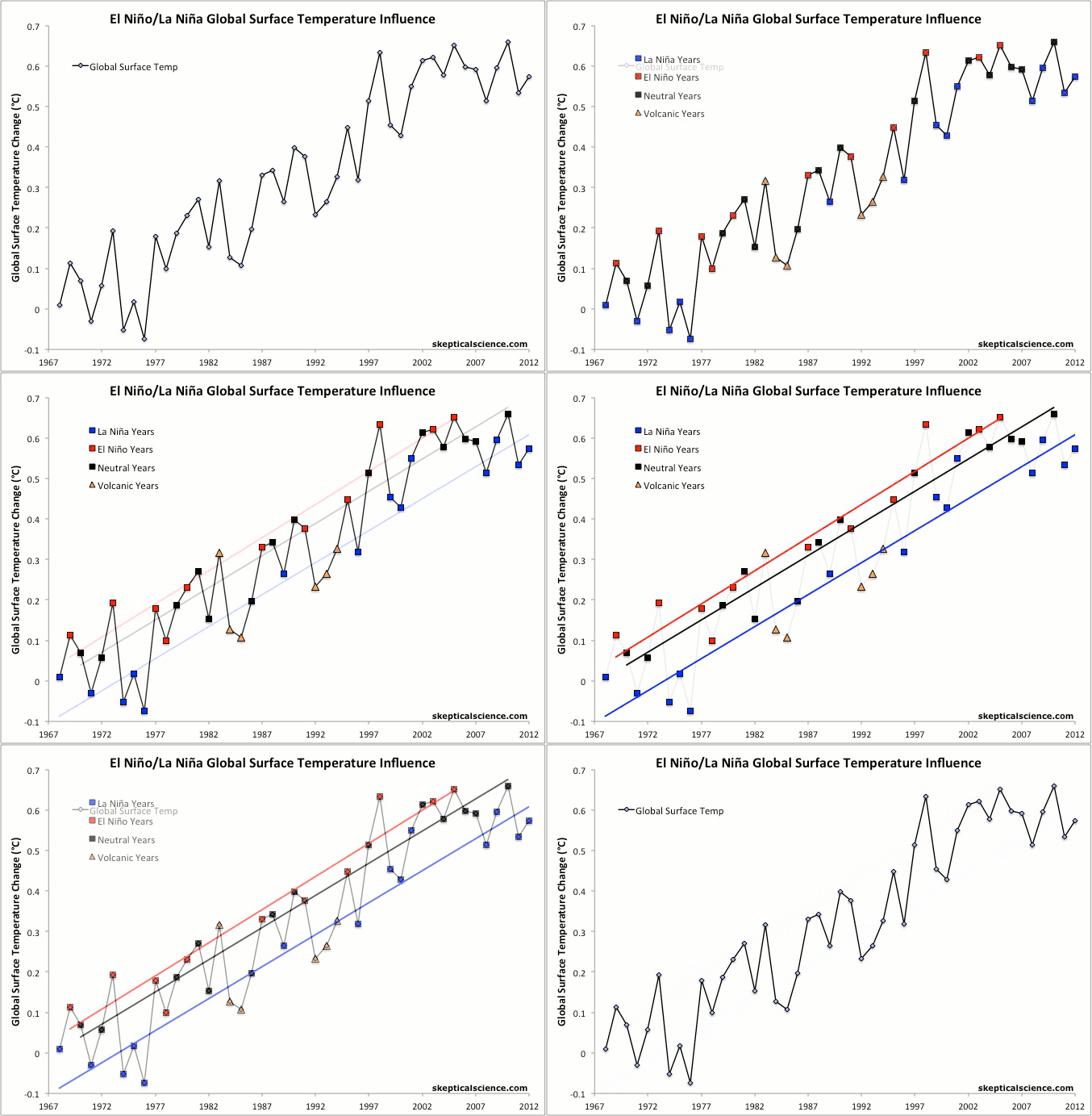
In essence, I'm simply grouping the years whose temperatures had the most (in the uppermost 33%) La Niña/El Niño influence over the past 45 years, and seeing what those groupings tell us.  I excluded years which were strongly influenced by the El Chichón (1983–1985) and Mount Pinatubo (1992–1994) volcanic eruptions (because large eruptions release particulates into the atmosphere which cause a strong short-term cooling), and looked at the temperature trends in each of the three categories (Figure 1).

Consistent Results

ENSO temps

Figure 1: NOAA annual global surface temperatures from 1968 through 2012 with La Niña years in blue, El Niño years in red, ENSO neutral years in black, and volcanic years as orange triangles.  Linear trends for 1968–2012 for each of the three categories (excluding volcanic years) are shown in the final frame.  Updated on the SkS animated graphics page.

The results are pretty interesting.  The trend for each of the three categories is 0.16°C per decade warming of global surface temperatures, consistent with the results in the analysis for Kevin C's "16 years" video

2012 in Context

2012 may reasonably be called a La Niña year (and the 2nd-hottest one on record, behind 2009), but it was not a strong one because ENSO switched to quasi-El Niño conditions for a few months in mid-2012, finishing the year in ENSO neutral conditions after the La Niña start to the year.  Based on my methodology, 2012 was the 14th-strongest La Niña year in the past 45 years, with a similar La Niña influence to those in 1968, 1996, 2001, and 2009.  According to NOAA, 2012 was 0.56°C hotter than 1968, 0.25°C hotter than 1996, 0.02°C warmer than 2001, and 0.02°C cooler than 2009. 

Of course as Kevin's video shows, ENSO isn't the only factor in addition to greenhouse gases to influence annual global surface temperatures.  There's also solar activity, human particulate emissions, other oceanic cycles, etc.  Nevertheless, as Figure 2 shows, 2012 falls very close to the long-term trendline for La Niña years.

La Niñas Have Dampened Recent Surface Warming

It's also interesting to note that four of the past five years qualify as La Niña years in my methodology - they are in the top 33% of the strongest La Niña-influenced years since 1968.  There has not been a similar El Niño year since 2005.  And half of the last 14 years qualify as La Niña years, compared to just two El Niño years since 1999.  Six out of the prior eight years (1991–1998) qualified as El Niño years, although three of those were obscured by the Mount Pinatubo eruption.

In short, global surface temperatures in the 1990s were mostly amplified by El Niños, while those in the 2000s and 2010s thus far have mostly been dampened by La Niñas - a recipe for a temporary surface warming 'pause'.  But when we break the data into La Niña/El Niño/Neutral categories, or when we filter out their effects as Kevin C did, we see that the underlying global surface warming trend of approximately 0.16°C per decade remains beneath the short-term noise.

0 0

Printable Version  |  Link to this page

Comments

Comments 1 to 24:

  1. I am a bit confused about 2010. Wasn`t it a moderate El Niño year? (Yes, I know there was a strong La Niña later in the year, but given the 4-month time lag between ENSO and global temperatures its effects were felt mostly during the next year, i.e. 2011)
    0 0
  2. From Peru @1 - not by my methodology. 2010 comes in at the 17th-strongest El Niño influence, putting it in the Neutral category. The La Niña conditions in roughly May-August were enough to bump it out of the top 15. Note that 2010 makes the top 15 El Niño years in ONI (#7), but just misses in MEI (#16), and was quite moderate according to SOI (#23), so it depends which measure of ENSO you want to use.
    0 0
  3. From Peru @1, even if you classified 2010 as an EL Nino year, it would not significantly affect the result of the graph. It would certainly not be as cool relative to trend as 1978 is for an El Nino year.
    0 0
  4. Can't believe this post has got me thinking in post-structuralist terms. Does the expression "warmest La Niña year" actually have any substantive content?
    0 0
  5. The +0.16C per decade surface warming is also the current average 30-year trend of all five main global temperature data sets. HadCRUT4: +0.16 GISS: +0.17 NCDC: +0.16 RSS: +0.15 UAH: +0.17 AVERAGE: +0.16 Just looking at the 30-year trend appears to be a good shorthand way of approximating the long term underlying warming rate. 16 years? Not so good.
    0 0
  6. Thanks for putting this in a graphic! separate lines on the chart for La Nina and El Nino years will help explain things greatly! Looking at the chart, it seems like the next proper El Nino year is going to be around 0.75 or even 0.8! That should put paid to the current round of "no warming since 1998" nonsense.
    0 0
  7. Very nice study that higlights the consistency of the GW signal. One small quibble, could you quote the errors on the trends for the 3 fits? What would happen if you regressed out the volcanic effects first?
    0 0
  8. jonthed at 00:35 AM on 22 January, 2013 You're right, even a neutral year (which is the forecast) should probably produce a record hot year. I wonder if there are other factors apart from this simple extrapolation that we're overlooking.
    0 0
  9. Probably a bit of splitting hairs here, but we probably need a more refined scale for classifying a year as El Nino, Neutral, or La Nina. Rather than these 3 categories, you probably would want 7, based on the following: Cat 1: Strong El Nino Cat 2: El Nino Cat 3: Weak El Nino Cat 4: Neutral Cat 5: Weak La Nina Cat 6: La Nina Cat 7: Strong La Nina Each of these categories would be set based on the total ONI index as measured in the three month periods across the year, such that, there must be an officially recognized El Nino or La Nina in the year (or ENSO neutral period) and : Cat 1: ONI yearly total is 5 or greater (ex. 2002 was 6.7) Cat 2: ONI yearly total is 3 to 5 (ex. 2009 was 3.8) Cat 3: ONI yearly total is 1 to 3 (ex. 2006 was 1.5) Cat 4: ONI yearly total is 0 to +1 or -1 (ex. 2012 est. to be about -0.7) Cat 5: ONI yearly total is -1 to -3 (ex. Cat 6: ONI yearly total is -3 to -5 (ex. 2010 was -3.2) Cat 7: ONI yearly total is -5 or less. (ex. 2011 was -15.2) We might even want 9 categories by adding a Super El Nino and Super La Nina with the Summed ONI going over 10 or under -10 respectively. We then would see how extraordinary 2011 was for such a very low total ONI, versus 2012 which was really an overall ENSO neutral to very weak La Nina year. Finally, it should also keep in mind that the peak in an El Nino and the resultant spike in tropospheric temperatures from the release of that heat from the tropical Pacific has about a 3-6 month lag or so, such that, in the 1997-1998 super El Nino, the ONI peaked in Dec. of 1997, but we didn't see the resultant peak in tropospheric temperatures until mid-1998, making it such a record warm year, even though the bulk of the El Nino was actually in 1997.
    0 0
  10. One follow-up to my previous post. It occurred to me that the classification system of El Nino/Neutral/La Nina in itself is based on historical standards of the + or = 0.5C standard during 5 consecutive 3 month periods. Such that if the ONI periods in a year looked like this: 0.5 0.5 0.5 0.5 0.4 0.5 0.5 0.5 0.5 0.4 0.5 0.5 No "official" El Nino would have taken place and it would officially be seen as an ENSO neutral year, yet if the next year looked like this: -0.5 -0.5 -0.5 -0.5 -0.4 -0.5 -0.5 -0.5 -0.5 -0.4 -0.5 -0.5 It too would be seen as a ENSO neutral year. Yet in the first case, by using my proposed "summed" ONI index (forgetting the official designation) that year would be seen as a strong El Nino year, and in the second case, that year would be seen as a strong La Nina year. It would be interesting to see the applicability using this summed ONI approach to predicting the resultant spike or drop in tropospheric temperatures for those periods.
    0 0
  11. R. Gates, while it might be desirable to include more categories as you suggest, the primary consequence would be to reduce the number of data points in each category so that no meaningful trend could be drawn. A more detailed examination which is dependent on the actual strength of the ENSO signal is provided by Kevin C's video.
    0 0
  12. The other effect La Ninas have achieved is the return of the sea level rise as David Appell succintly cherry-picks: Link. 18mm/year, AAAAAhhh, we're going to drown!! But I'd guess that the floods in various areas of the world will be less because of this.
    0 0
    Moderator Response: [PW] Hot-linked reference
  13. Well done Dana. Given the number of years in the record, three categories was just right for obtaining a meaningful comparison. Trend similarity is quite striking.
    0 0
  14. R. Gates at 07:25 AM on 22 January, 2013 Or maybe it could be done with monthly figures, and thus one would not have to categorize the years at all. I don't think it would change the main conclusions, though: under similar oceanic/volcanic conditions, anthropogenic warming rate keep on going.
    0 0
  15. Is interesting to see the 0,16 ºC/decade figure appearing so often and using different methods to filter short term influences from the global temperature data. To me it looks like a fairly robust result. Just one nitpick, would it be possible to have some error bars in those trends?
    0 0
  16. If I could have a little help on a topic that I think applies to this forum. I was given this link stating that 2006 should now be a la nina year and therefore 2012 is no longer the warmest la nina year on record. Link What constitutes a neutral year? 2006 starts with a la nina event and ends with a El Nino event. I suspect that Tisdale is being his PR WUWT self, I would just like to know the details of this.
    0 0
    Moderator Response: [PW] Hot-linked reference.
  17. renewable guy @16 - I think Tisdale is correct that Figure 1 in this post is based on an older version of the ONI which has now been superceeded, and that by their definition (first 3 months being La Niñas), 2006 should be the hottest La Niña year on record according to NOAA. Based on my methodology, 2006 is a Neutral year. However, 2009 was a slightly warmer La Niña year than 2012, as noted in the post above.
    0 0
  18. Link in #16 is broken (the URL should be clipped following the "year/" part of the string, if that makes sense). With reference to Tisdale's claims, he might be onto something with regards to the nitpick about whether 2006 is a neutral year or not. The NOAA website states:
    DESCRIPTION: Warm (red) and cold (blue) episodes based on a threshold of +/- 0.5°C for the Oceanic Niño Index (ONI) [3 month running mean of ERSST.v3b SST anomalies in the Niño 3.4 region (5°N-5°S, 120°-170°W)], based on centered 30-year base periods updated every 5 years. For historical purposes cold and warm episodes (blue and red colored numbers) are defined when the threshold is met for a minimum of 5 consecutive over-lapping seasons.
    The OP here cites NOAA as defining a La Nina year as:
    NOAA defines a La Niña year as one in which the first 3 months meet the La Niña criteria that the Oceanic Niño Index (ONI) is less than -0.5.
    (This is a paraphrase of the State of the Climate report.) Of course, even if that is the case, it's spun all out of proportion to its importance relative to what is known/not known about global warming. Certainly it offers no support to Tisdale's unphysical pet notion that ENSO drives the apparent global warming. Bottom line: - It looks (to me, anyway) that Tisdale is correct in pointing out that, by NOAA's own standards, 2006 is a La Nina year and is warmer than 2012. - After that, Tisdale's got nothing, insofar as he is trying to take an apparent error in classification and transmogrify it into a refutation of conclusions based on physics.
    0 0
  19. Apparantly from Dana and Composer99's comments above, Tisdale's nit pick is correct. I cannot help noticing, however, that 2007 lies above the trendline for La Nina years, and below the trend line for neutral years. Classifying it as a La Nina year, therefore, would increase the trend for both. (While we are nitpicking.)
    0 0
  20. ooops, never mind.  NOAA retracts claim!

    0 0
  21. Kevin C @20, it is worth quoting NOAA's retraction (in an update at the top of the page) in full:

    "Note: On January 15, 2012, NCDC announced as part of its 2012 Global Climate Report that 2012 was the warmest La Niña year on record. While there are a variety of approaches for defining a La Niña or El Niño year, NCDC's criteria is defined as when the first three months of a calendar year meet the La Niña or El Niño threshold as defined by NOAA Climate Prediction Center's (CPC) Oceanic Niño Index (ONI). The list of historical La Niña years released on January 15 was based on an ONI dataset in force in early 2012 and used a 1971–2000 base period. During the course of the year, CPC introduced an ONI dataset using different base periods for determining anomalies for each year, with the most recent years (1995 to date) utilizing the 1981–2010 base period. Because of long-term warming trends in the equatorial Pacific Ocean, applying this more recent base period allows for better discernment of the temperature patterns needed to identify El Niño and La Niña years. In the most recent version of the dataset, using the newer base period methodology, 2006 and 2009 are now classified as La Niña years. The global average temperature in both 2006 and 2009 was 0.02°C (0.04°F) higher than 2012, making these two years the warmest La Niña years on record. NCDC has updated (via strikeout) our Annual Global Climate report to reflect the most current CPC ONI dataset.

    With binary definitions of El Niño or La Niña, small changes in processing the data can affect the classification of weak El Niños or La Niñas. Despite these reclassifications, the general conclusions are similar from previous work: (1) global temperature anomalies for each phase (El Niño, La Niña, and neutral) have been increasing over time and (2) on average, global temperatures during El Niño years are higher than neutral years, which in turn, are higher than La Niña years.

    NCDC continually examines its practices and definitions as science, datasets, and the understanding they bring improve. Thus, given the nature of our current method of classifying years as El Niño or La Niña, NCDC plans to re-examine and employ the best available definitions and datasets to robustly characterize the influence of El Niño and LaNiña on annual global temperatures."

    (My emphasis)

    It should be noted that, even with the updated list, 2012 is still the third warmest La Nina year on record.  Also of interest, the two years, now considered La Nina years by NOAA, but previously considered neutral years are 2006 and 2009.  Of these, 2009, but not 2006, is considered a La Nina year using Dana's methodology in figure 2 above.  It should further be noted that both 2006 and 2009 are above the trend for La Nina years, and below the trend for neutral years.  It follows that reclassifying them will increase the trend for  both neutral and La Nina years.  Naturally this last point recieves no attention from AGW deniers.


    0 0
  22. Recommend that the text of NOAA's retraction be appended to the OP. 

    0 0
  23. John Hartz @22 - it has been.  See the first line.

    0 0
  24. Dana @23:

    I was aware of the embedded link to the NOAA retraction. My recommendation is to post the text of it at the end of the OP as well. Not everyone follows links.  

    0 0

You need to be logged in to post a comment. Login via the left margin or if you're new, register here.


The Consensus Project Website

THE ESCALATOR

(free to republish)


© Copyright 2024 John Cook
Home | Translations | About Us | Privacy | Contact Us