


 Arguments
Software
Resources
Comments
The Consensus Project
Translations
About
Support
Arguments
Software
Resources
Comments
The Consensus Project
Translations
About
Support
![]()
![]()
![]()
![]()
![]()
![]()
![]()
![]()
![]()
![]()


![]()


Latest Posts
- Skeptical Science New Research for Week #26 2026
- What Americans can learn from London’s war on cars
- New Publication: Identifying Flawed Reasoning in Contrarian Claims about Climate Change
- The Merchants of Doubt are coming for Extreme Event Attribution science
- 2026 SkS Weekly Climate Change & Global Warming News Roundup #25
- Cooking up the Climate Stripes, with Ed Hawkins
- Skeptical Science New Research for Week #25 2026
- How ‘balcony solar’ could help fight rising utility costs
- Fact brief - Does solar energy need subsidies to compete with fossil fuels?
- Plateauing CO2 emissions have slowed atmospheric growth
- 2026 SkS Weekly Climate Change & Global Warming News Roundup #24
- Skeptical Science New Research for Week #24 2026
- June update: Help still needed to get translations prepared for our website relaunch!
- How many people does heat actually kill?
- Check out the brand-new hurricane ‘cone of uncertainty’ graphics arriving this season
- 2026 SkS Weekly Climate Change & Global Warming News Roundup #23
- SkS Housekeeping: Updating the Comments Policy
- Skeptical Science New Research for Week #23 2026
- Nobody knows the future of energy
- Fact brief - Do electric vehicles almost always have a lower carbon footprint than gasoline-powered cars?
- Solar, wind, and EVs have knocked out a doomsday climate scenario
- 2026 SkS Weekly Climate Change & Global Warming News Roundup #22
- Skeptical Science New Research for Week #22 2026
- The next era of Atlantic hurricanes could be far more destructive
- On the death of RCP8.5
- RCP8.5 Update
- 2026 SkS Weekly Climate Change & Global Warming News Roundup #21
- Skeptical Science New Research for Week #21 2026
- What’s a ‘super El Niño’? And other El Niño questions, answered
- Fact brief - Does electromagnetic radiation from wind turbines pose a threat to human health?
Archived Rebuttal
This is the archived Intermediate rebuttal to the climate myth "Satellite record is more reliable than thermometers". Click here to view the latest rebuttal.
What the science says...
|
Satellites don't measure temperatures, and their uncertainty is five times as large as that in the global surface temperature record. |
Satellites don't measure temperature. When people refer to the satellite temperature record, they're referring to microwave sounding unit (MSU) instruments on satellites. As Andrew Dessler describes in the video below by Peter Sinclair, MSUs measure voltages on detectors, which themselves are detecting microwave signals emitted by oxygen molecules in the Earth's atmosphere. To translate these voltages and microwave detections into estimates of the temperature of various layers of the Earth's atmosphere requires a model.
Satellite Temperature Record Challenges
Converting those MSU microwave detections into a reliable long-term atmospheric temperature record is a challenging proposition, made all the more difficult by a number of confounding factors. For example, the satellites have a limited life span. The overall satellite MSU record is comprised of numerous satellites, and each has a different calibration, orbit, etc. that must be accounted for. During that life span, the satellites also experience friction, which causes their orbits to drift. If not correctly taken into account, these factors can create a bias in the estimated temperature record.
Another issue is that the MSU detections can be influenced by factors besides just temperature-influenced oxygen microwave signals, for example, cloud liquid water. Weng et al. (2014) found that the MSU channel (Channel 3) that focuses on the lowest level of the atmosphere (the lower troposphere) is most influenced by the presence of cloud liquid water. Weng et al. suggest,
the global mean temperature in the low and middle troposphere has a larger warming rate (about 20–30% higher) when the cloud-affected radiances are removed from AMSU-A data.
Roy Spencer who, with John Christy, runs the University of Alabama at Huntsville (UAH) satellite temperature dataset disagrees, believing that the cloud-caused bias is insignificant. The magnitude of this bias in the satellite data remains an unresolved question.
Another issue related to changes in the satellites' orbits is called 'diurnal drift'. The satellites are in 'Sun Synchronous orbits' and are meant to stay aligned with the Sun so that they always cross the equator at the same time. If they don’t, then the normal daily temperature cycles below will start to add a false bias to the data. The UAH team tries to get around this bias by attempting to use these satellites during periods when the diurnal drift is small, while other groups (RSS and NOAA) apply a correction based on the diurnal drift in a global climate model. Po-Chedley et al. (2015) argue that the UAH method creates a cool bias in their dataset.
There are still further challenges, for example the fact that the increased greenhouse effect cools the stratosphere, which is the layer of the atmosphere above the troposphere. If microwave measurements from the stratosphere bleed into estimates of tropospheric temperatures, that can also cause a cool bias in the trend. The figure below shows all the processing required to get from voltage measurements on an MSU sensor to an estimate of the temperature in the atmosphere.
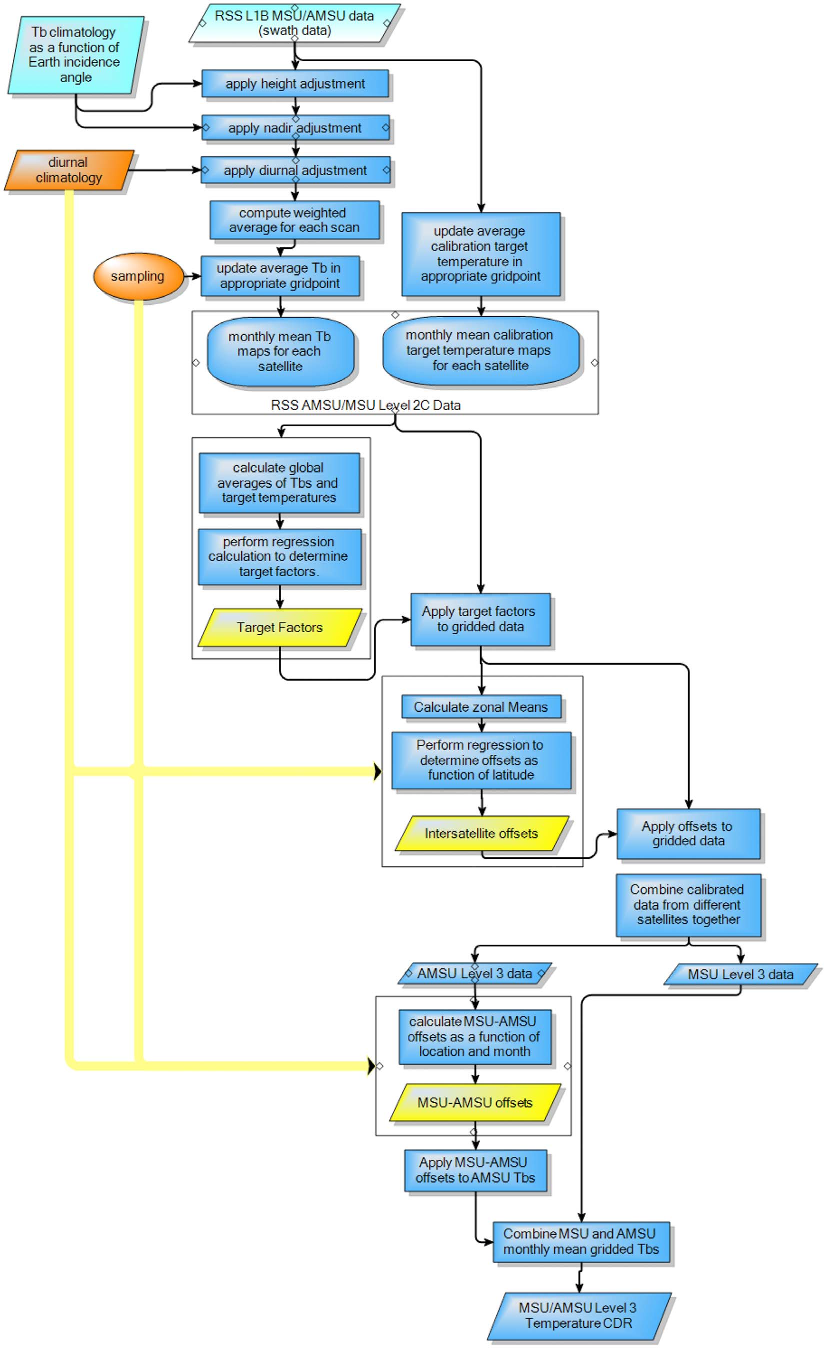
Flowchart of the processing algorithm for the RSS satellite data, from Mears et al. (2011)
As a result, the uncertainty in the satellite data is five times larger than that in the surface temperature record, which is based on direct measurements by thermometers.
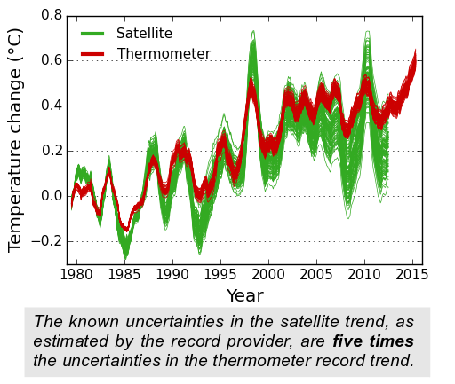
Spread in the satellite and surface temperature ensembles over time. Each line shows one possible temperature reconstruction from the ensemble (12 month moving average). All of the series have been aligned to a zero baseline for the 10 year period 1979-1988, so that the increasing spread after that period gives an indication of the variability in the trend. Created by Kevin Cowtan.
on the basis of the best understanding of the record providers themselves, the surface temperature record appears to be the better source of trend information. The satellite record is valuable for its uniform geographical coverage and ability to measure different levels in the atmosphere, but it is not our best source of data concerning temperature change at the surface.
What makes "the best" the best?
This particular myth deals with the claim that the satellite data are "the best data we have" for measuring global warming. What's "best" is a subjective judgment call, but if the goal is to have greater certainty about the data and trends, the surface temperature record is "better" than the satellite data.
Additionally, only about 2% of the global energy imbalance goes into warming the atmosphere. Over 90% goes into warming the oceans, so if the goal is to best measure the overall warming of the Earth, ocean heat content data would be "the best" single source.
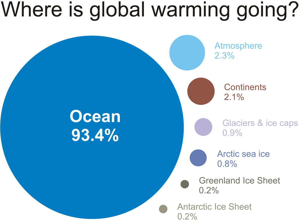
A visual depiction of how much global warming heat is going into the various components of the climate system for the period 1993 to 2003, calculated from IPCC AR4 5.2.2.3.
Another consideration is that humans live on the surface, not kilometers up in the atmosphere. The surface temperature record measures temperature changes where we live, which is arguably the most relevant in terms of effects on human society. By that standard, the surface temperature record would be "the best."
Updated on 2016-01-14 by dana1981.


THE ESCALATOR

(free to republish)