Scientists discuss how strongly a warming Arctic is implicated in extreme weather
Posted on 29 May 2015 by Guest Author
This is a re-post from Carbon Brief by Robert McSweeney
The possibility that a warming Arctic could be influencing extreme weather elsewhere in the world seemed to receive a boost this week. A new paper presented further evidence linking diminishing Arctic sea ice to extreme cold winters elsewhere in the northern hemisphere.
Lead author, Prof Jennifer Francis from Rutgers University, tells us: "Our new results, together with other new studies in this field of research, are adding substantial evidence in support of the connection."
But not everyone is so sure. We asked a few scientists in the field how strong they consider the evidence linking Arctic sea ice and extreme weather to be. Here's what they told us.
Arctic amplification
The US, Canada, Japan and UK have all experienced very cold and snowy winters in recent years. In 2012, a paper by Francis and Dr Stephen Vavrus suggested that this extreme weather was a result of rapid warming in the Arctic.
Temperatures in the Arctic are increasing around twice as fast as the global average. As Arctic sea-ice diminishes, energy from the sun that would have been reflected away by sea-ice is instead absorbed by the ocean, a phenomenon known as Arctic amplification.
Francis and Vavrus suggested that warmer Arctic temperatures weaken the jet stream, a fast-flowing river of air high up in the atmosphere. The theory goes that a weaker jet stream becomes 'wavier' and leads to more persistent weather conditions, such as long cold spells in winter and heatwaves in summer.
The new paper by the same authors, published this week in Environmental Research Letters, offers further evidence to support the link.
Jet stream waviness
Francis and Vavrus' work triggered what has become a lively area of research. One of the difficulties with the theory proposed is that it's very hard to measure the 'waviness' of the jet stream directly. Instead, Francis and Vavrus use a number of metrics to measure it in other ways.
One method tries to see the mechanism in action by looking for evidence of temperature differences causing wind patterns to change and the jet stream to get wavier. Another way looks at whether these wavy jet stream patterns are occurring more frequently across the northern hemisphere.
Identifying these patterns of waviness is important because they lead to 'blocking', which causes cold weather patterns to hold on for longer. In the 2013-14 US winter, the prolonged spell of very cold weather caused 91 per cent of the Great Lakes to freeze over.
Francis says we're seeing more of this persistent extreme weather as the Arctic warms up:
"Occurrence of these events has increased during recent decades when Arctic amplification has emerged as a strong signal."
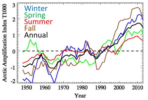
Arctic amplification is greatest in autumn and winter (see graph below), which is why it mainly results in persistent cold weather events, Francis explains.
Timeseries of the Arctic amplification index for each season. A positive index indicates that the Arctic is warming faster than the mid-latitudes. Source: Francis & Vavrus (2015).
Controversial theory
Understanding the effect Arctic amplification could be having in other parts of the world is tricky because it's a relatively recent phenomenon. Francis and Vavrus define the 'Arctic amplification era' as beginning in 1995, which gives scientists less than 20 years' of data to work with.
As Dr James Screen from Exeter University tells us:
"The changes are only seen over a very short period, so it is impossible to say if they are secular trends or just natural variability."
Another issue is how you define jet stream 'waviness', as Prof Ian Simmonds from the University of Melbourne explains:
"Getting an appropriate definition is important, as conclusions as to whether waviness is increasing or decreasing seem to depend on the metrics being used."
As a result, not all scientists have been won over by the theory. Francis acknowledges that Arctic warming contributing to a wavier jet stream is the "most controversial aspect of the hypothesis we proposed in our 2012 paper."
The Arctic may not be to blame
Scientists also haven't ruled out other factors being involved in the extreme weather, as Screen tells us:
"Correlation and trends doesn't tell you cause and effect. It is still impossible to pin the blame on the Arctic, so to speak."
A paper published in October last year, for example, finds that temperature changes in the Atlantic ocean could be triggering warm conditions in the Arctic, and cold weather over Europe and Asia. Simmonds says findings such as these mean there is still doubt regarding the Arctic's influence:
"Seen in this light, the magnitude of the direct influence of a warm Arctic on mid-latitude extremes becomes more problematic."
So it seems that scientists are still some way from agreeing on what's causing these cold winters. As Screen puts it:
"Without evidence of causality or a convincing dynamical mechanism, I would say the evidence still remains suggestive but far from conclusive."
Pinpointing if and how the Arctic is implicated in extreme weather around the rest of the world is clearly of huge interest, stretching beyond just scientific circles. But teasing out the details is still a very new and active area of research, making this topic one to watch in 2015.
Francis, J.A. and Vavrus, S.J. (2015) Evidence for a wavier jet stream in response to rapid Arctic warming, Environmental Research Letters, doi:10.1088/1748-9326/10/1/014005 [This article is open-access and therefore free to download.]


 Arguments


Unfortunately the plight of the Arctic appears to be even more dire due to the Obama administration sanctioning Shell to drill for oil and gas in the region
Implying that the jet stream pushes weather systems around the world is a little like the plumb pudding model of an atom. It was fine until the solar system model explained a few more characteristics of atoms and this was fine until the sub orbital model explained even more. In fact, the jet stream marks the location where Hadley cells come together and the jet streams form at this junction high in the sky. Between the Polar Hadley cell and the Feral cell is a rising wall of air and between the Feral cell and the equatorial Hadley cell a falling wall of air. Surely these walls of air are what is pushing weather systems and the upwhelling and downwhelling is marked by the jet stream. It may sound like nit picking but perhaps we will achieve deeper understandings just as when each atomic model was upgraded. All this is powered by rising heated air at the equator and falling cold air at the pole. What should be interesting is when the Arctic Ocean collects enough heat in the summer due to being open ocean, to reverse the Polar Hadley cell, especially in the fall as the surrounding land quickly cools off and the ocean is relatively warm. That is just when the grain crops of the Northern Hemisphere are ripening. The junction between the Hadley cells is showing deeper and deeper wobbles. It brings to mind a top that begins to wobble as it slows down just before it falls over.
William, I am not familiar with this theory. Although I get the AMS' BAMS (Bulletin of American Meteorological Society) regularly, I have not seen any theorizing on this possibility. Perhaps I have just not paid attention. At this point I find it hard to see the Polar, Feral, and Hadley cells turning. The driving force is much larger from the tropics to the North, since there is so much more insolation at the tropics then at the poles. The energy budgets are just too big to see them reversing in a any realistic scenario, no matter how warm the poles get; although, I could be convinced with some evidence.
William @2,
I think your view of Hadley cells is a bit simplistic. While in general terms the cells can be viewed as spinning wheels, driven by latitudes of rising and falling air, it's not nearly that static. If it were, it would be very easy to measure, and you couldn't possibly have air masses, hurricanes, ENSO events, or the like, because no air mass could ever cross those boundaries intact. The reality is, I think, that the atmosphere is much more fluid and dynamic than that. The locations and "forces" in play with the Hadley Cells cannot be viewed as a "wall of air". It's not that concrete.