Climate Science Glossary

Term Lookup

Enter a term in the search box to find its definition.

Settings

Use the controls in the far right panel to increase or decrease the number of terms automatically displayed (or to completely turn that feature off).

Term Lookup

Settings


All IPCC definitions taken from Climate Change 2007: The Physical Science Basis. Working Group I Contribution to the Fourth Assessment Report of the Intergovernmental Panel on Climate Change, Annex I, Glossary, pp. 941-954. Cambridge University Press.

Home Arguments Software Resources Comments The Consensus Project Translations About Support

Bluesky Facebook LinkedIn Mastodon MeWe

Twitter YouTube RSS Posts RSS Comments Email Subscribe


Climate's changed before
It's the sun
It's not bad
There is no consensus
It's cooling
Models are unreliable
Temp record is unreliable
Animals and plants can adapt
It hasn't warmed since 1998
Antarctica is gaining ice
View All Arguments...


Username
Password
New? Register here
Forgot your password?

Latest Posts

Archives

Thinning on top and bulging at the waist: symptoms of an ailing planet

Posted on 14 July 2011 by Andy Skuce

Like many an aging baby boomer, the Earth is starting to bulge at the waist and is getting thinner on top. In the Earth’s case this isn’t due to a weakness for drinking beer or due to an inherited tendency towards male pattern baldness. Rather, it is because of climate change. As the big ice sheets in Greenland and Antarctica thaw, the melt water is distributed throughout the world’s oceans, causing mass to move away from the poles.

The earth is not exactly round, it’s slightly flattened at the poles and bulging at the Equator. The radius of the Earth measured from its center to sea level at the poles (or where sea level would be at the South Pole if there were no continent there) compared to the radius at the Equator, differs by about 21 km. This means that the point on the Earth’s surface furthest away from its center is not the summit of Everest but rather the top of the volcano Chimborazo in Ecuador. Although the summit of Chimborazo is 2,500 meters less high above sea level than Everest, it is also much closer to the Equator and hence further from the center of the Earth. The reason that the Earth is not quite round is mainly because it spins on its axis through the poles; the centrifugal forces acting on the rocks of the Earth, which are somewhat ductile, tend to push out the parts furthest away from the axis.

The amount of flattening (or oblateness) of the Earth can be represented by a gravitational parameter known as J2. See here for a definition. This parameter has been measured since the mid-1970’s by satellite laser ranging (SLR) and is found to vary from year to year due, among other things, to the ENSO, the El Niño/La Niña oscillation in the Pacific. See Figure 1 below and here, also.

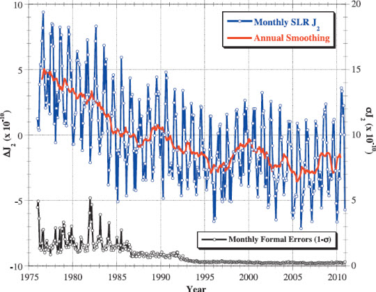
Figure 1. Measurements of changes in J2 (the Earth’s flatness or oblateness) from satellite laser ranging (SLR, not to be confused with sea-level rise), from Nerem and Wahr (2011). Note the declining trend in J2 from the mid-1970's until the mid 1990's. 

From 1976 to 1995 there was also a steady gradual trend downwards, with the Earth’s flatness steadily decreasing due to glacial isostatic adjustment (GIA), which is a long term bouncing back of the Earth’s crust and uppermost mantle, mainly in Canada and NW Europe, due to the melting of the big ice sheets after the last ice age.  See Botai and Combink (2009). Something changed in the mid 1990’s.

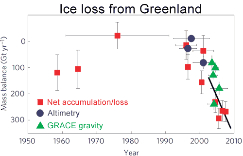
Figure 2.  Rate of ice loss from Greenland. Vertical lines indicate uncertainty, horizontal lines indicate averaging time. Blue circles are from altimetry, red squares are from net accumulation/loss and green triangles are from GRACE. The black line is a straight-line (constant acceleration) fit through the mass balance data for the period 1996–2008 with a slope of 21 gigatonnes/yr2 (Jiang 2010).

What changed was that the ice sheets in Greenland—and probably Antarctica—started melting faster in about 1996. The water from the melted ice disperses quickly around the globe. The global effects from additional isostatic adjustments from this latest melting will take a much longer time to take effect. In a paper by R.S, Nerem and J. Wahr that’s currently in press in Geophysical Research Letters, the results from the SLR observations are combined with data from the GRACE satellites.

GRACE is a system of two satellites that circle the Earth together, one following the other by 220km. When the lead satellite (“Jerry”) approaches an area of relatively higher mass it speeds up a little and it draws slightly ahead of the other satellite (“Tom”). By measuring the small variations in the distance between the two, gravity anomalies can be calculated with great accuracy.

The GRACE data show that the Greenland and Antarctic ice sheets have been losing mass since 2002, when measurements began. Nerem and Wahr calculated what effect this redistribution of mass would have on the Earth’s shape. They also removed the long period trend due to glacial isostatic adjustment (GIA) since the last ice age, using a GIA model from Paulson et al (2006) .  


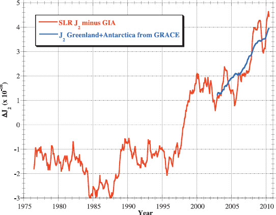
Figure 3. From Nerem and Wahr (2011) showing the residual in the change in J2 (red) measured by SLR, after removing the trend due to GIA; alongside the J2 change expected from the melting of the Greenland and Antarctic ice sheets combined (blue), measured since 2002 by GRACE.

The graph shows how the residual trend in J2 since 2002 is closely accounted for by ice melt from the high latitudes and that it seems reasonable to speculate that the similar trend in J2 since the mid-1990’s was due to the same cause.

Attentive readers of Skeptical Science will have already noted in Figures 1 and 3 that we have a new hockey stick, albeit  a junior one with a shaft that goes back only to 1975 and a blade that started around 1995. Nevertheless, it, along with the many others in the team’s locker room (here, here, here and here), shows that recent and sudden changes in the Earth’s climate are being manifested in many different, measurable ways, including, now, the shape of the Earth.

Hat-tip to Friends of Gin and Tonic

0 0

Printable Version  |  Link to this page

Comments

Comments 1 to 10:

  1. [snipped] The data is exactly tied to this topic and based on hard scientific findings. Repost with content: Today the Pine Island Glacier in Antarctica is quickly melting downward from the surface – dropping in altitude at nearly 16 meters per year. With an area over 5 thousand square kilometers, this glacier holds a lot of cubic meters of ice and means that a lot of weight is now getting shifted into the ocean. Similarly, the melting of glaciers in Greenland and elsewhere will trigger seismically elastic reactions that should be noted for their frequency, intensity and novel locations. Connecting the Dots: Climate Change drives Earthquake / Seismic activity
    0 0
    Moderator Response: (Rob P) Note the commenting rules. No links only. Provide some discussion or context, or risk the comment being deleted. Thanks for your future co-operation.
  2. Earth rotation period does not seam to have such a nice signature: http://hpiers.obspm.fr/eop-pc/earthor/ut1lod/lod-1623.html Or, the pole coordinate: http://hpiers.obspm.fr/eop-pc/products/combined/C01plot.php?date=2&graphe=2&deb=1846&fin=2011&SUBMIT2=Soumettre+la+requ%EAte
    0 0
  3. Good article on the mass re-distribution occurring due to the melting ice-sheets. One minor nitpick, being a science blog wouldn't it be better to avoid using fictional forces in discussing such as the earth's bulge at the equator? I suppose it's easier to say centrifugal as it's "common knowledge" and all, but I spend a lot of time trying to explain to kids that it's not a real force. Again, a minor nitpick. Thanks for posting this, Andy.
    0 0
  4. WSteven: Yes, thanks, you are right, centrifugal force is a fictional force, like the Coriolis force, but I figured that the people who already knew why the equator bulged wouldn't be confused by the term and those who didn't know wouldn't have heard of centripetal forces. There's often a trade-off between precision and clarity when it comes to terminology.
    0 0
  5. Yvan Dutil You are correct that change day length is rather less of a tidy story than the changes in oblateness measured by SLR and GRACE. Day length is affected not only by mass distribution changes in the atmosphere, oceans, cryosphere and lithosphere but also by changes in angular momentum in the Earth's outer, liquid core. Dynamical effects in the outer core produce measurable changes in day length with a cycle of 65-80 years. You may find this article to be of interest.
    0 0
  6. About two months ago, a paper by Roy & Peltier was published. Their results are very well in line with this new study: "Recent trends in the two primary anomalies in the rotational state of the planet are analyzed in detail, namely those associated with the speed and direction of polar wander and with the non-tidal acceleration of the rate of axial rotation (via the measurement of the changing oblateness of the Earth's shape). It is demonstrated that a significant change in the secular trends in both of these independent parameters became evident subsequent to approximately 1992."
    0 0
  7. I've wondered about this movement of mass from the poles to the equator, and due to conservation of angular momentum, it seems likely that the rotation of the earth will slow, somewhat. More importantly, though, how will the stresses due to conservation of angular momentum be transmitted from the oceans and crust to the mantle and core? Could we be triggering a geomagnetic reversal, changing the relative rotation rates of the mantle and core? Googling around, I found this old paper by Berkeley's controversial Richard Muller, unfortunately hidden behind a pay wall: http://www.agu.org/pubs/crossref/1986/GL013i011p01177.shtml
    The impact of a large extraterrestrial object on the Earth can produce a geomagnetic reversal through the following mechanism: dust from the impact crater and soot from fires trigger a climate change and the beginning of a little ice age. The redistribution of water near the equator to ice at high latitudes alters the rotation rate of the crust and mantle of the Earth. If the sea‐level change is sufficiently large (>10 meters) and rapid (in a few hundred years), then the velocity shear in the liquid core disrupts the convective cells that drive the dynamo. The new convective cells that subsequently form distort and tangle the previous field, reducing the dipole component near to zero while increasing the energy in multipole components. Eventually a dipole is rebuilt by dynamo action, and the event is seen either as a geomagnetic reversal or as an excursion.
    What we're doing by AGW is rapidly shifting mass from the poles to the equator, the opposite of Muller's hypothesis, which shifts mass rapidly from the equatorial regions to the poles. But the geomagnetic disruption due to conservation of angular momentum may be the same in each case.
    0 0
  8. Apologies if this is a simplistic question, but as melted ice is so fluid, aren't we likely to experience more sea-level rise at the equator than in the higher latitudes as ice melts? If so, by how much? The other thought that occurs is; how do we know that the earth is oblate, when all heights are referenced above sea level and -- by definition -- because of its fluidity, the sea bulges outwards towards the equator on a spinning globe? I suppose the other way of asking this is, if all the water dried up would the oblateness still be as visible?
    0 0
  9. John Russell: The melt water from the ice sheets is distributed (to a first approximation, it's always more complicated!) evenly over the entire ocean surface of the world. The reason the planet's shape changes is because the ice at high latitudes is removed. Simply adding water to the oceans from some other source wouldn't necessarily increase the oblateness. The shape of the Earth, referenced to sea level, the Geoid, is not a smooth or simple geometric surface but is actually lumpy, due to gravity variations arising from the uneven distribution of density in the Earth. It would be harder to visualize the oblateness of the Earth if there were no oceans but the shape of the geoid is a useful and measured quantity, even in the center of continents. Other planets and the Moon (in fact, any body that spins on its axis) also have known oblate shapes, despite having no oceans.
    0 0
  10. Added: There's a good Scientific American article on the Geoid that's worth a read.

    0 0
    Moderator Response:

    [DB] Updated link to SA article.

You need to be logged in to post a comment. Login via the left margin or if you're new, register here.


The Consensus Project Website

THE ESCALATOR

(free to republish)


© Copyright 2024 John Cook
Home | Translations | About Us | Privacy | Contact Us