


 Arguments


The Larsen C ice shelf collapse hammers home the reality of climate change
Posted on 12 June 2017 by John Abraham
Very soon, a large portion of an ice shelf in Antarctica will break off and collapse into the ocean. The name of the ice shelf is Larsen C; it is a major extension from of the West Antarctic ice sheet, and its health has implications for other ice in the region, and sea levels globally.
How do we know a portion is going to collapse? Well, scientists have been watching a major rift (crack) that has grown in the past few years, carving out a section of floating ice nearly the size of Delaware. The speed of the crack has increased dramatically in the past few months, and it is nearly cracked through.
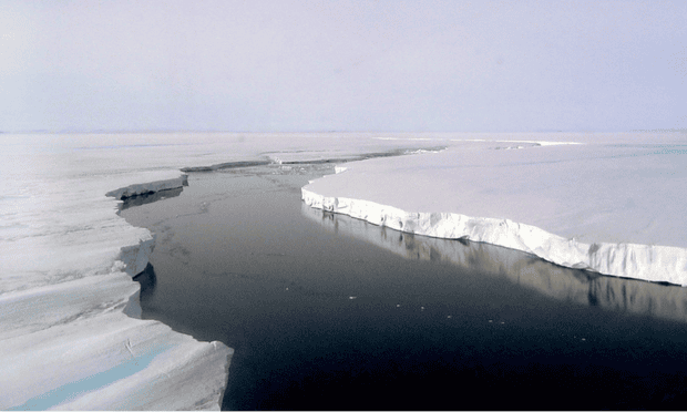
Crack in Larsen C ice shelf. Photograph: Ted Scambos, NSIDC
Project Midas provides frequent updates on the Larsen C shelf. You can read a summary there, which reports:
In the largest jump since January, the rift in the Larsen C Ice Shelf has grown an additional 17 km (11 miles) between May 25 and May 31 2017. This has moved the rift tip to within 13 km (8 miles) of breaking all the way through to the ice front, producing one of the largest ever recorded icebergs. The rift tip appears also to have turned significantly towards the ice front, indicating that the time of calving is probably very close.
The rift has now fully breached the zone of soft ‘suture’ ice originating at the Cole Peninsula and there appears to be very little to prevent the iceberg from breaking away completely.
When it calves, the Larsen C Ice Shelf will lose more than 10% of its area to leave the ice front at its most retreated position ever recorded; this event will fundamentally change the landscape of the Antarctic Peninsula. We have previously shown that the new configuration will be less stable than it was prior to the rift, and that Larsen C may eventually follow the example of its neighbor Larsen B, which disintegrated in 2002 following a similar rift-induced calving event.
Dr. Stefan Rahmstorf provided me an excellent image from his book Our Threatened Oceans. This image shows prior breakup of regions A and B (along with the location and size of part C).
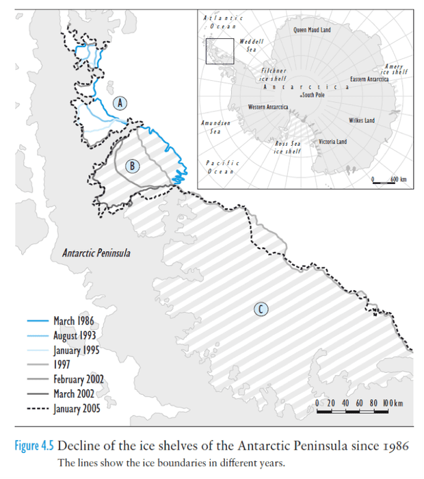
Larsen Ice Shelf decline. Illustration: Our Threatened Oceans by Stefan Rahmstorf, using British Antarctic Survey data
Why does all this matter? Well it is important for a number of reasons. First, when an ice shelf melts or collapses, it can unpin other ice that is sitting on land, which allows it to flow more quickly into the ocean. It is this secondary effect – the loss of ice resting on land – that changes the rate of sea level rise. Loss of a major ice shelf can also activate ice that rests on bedrock topography that makes it fundamentally unstable – ice that, once moving, will move faster and faster, until a large region is afloat.
The entire Larsen Ice shelf, which is the fourth largest in Antarctica, covers nearly 50,000 square km (20,000 square miles) according to reporting at ABC science. The ice on the land upstream of the shelf is enough to raise sea level, eventually, by ten centimeters. This is not, by itself, a major threat to the world’s coastlines, but it reveals the path that other, even larger areas are likely to take in the future.
Perhaps a quotation from a seminal work on Antarctic ice sheets best sums up the situation. In a 1978 paper, John Mercer from the Institute of Polar studies concluded:
One of the warning signs that a dangerous warming trend is under way in Antarctica will be the breakup of ice shelves on both coasts of the Antarctic Peninsula, starting with the northernmost and extending gradually southward. These ice shelves should be regularly monitored by LANDSAT imagery.
Why is the ice shelf going to break off and collapse into the ocean? Since large calving events are so rare, and since our measurements in and around ice shelves don’t go back in time far enough, it’s hard to say whether this is a natural progression, variability, or a result of human activity (or more likely a mixture). A major reason may be human-caused warming, which has led to melting from both above and below in nearby areas. The Western Antarctic (the parts south of the U.S.) is warming quite quickly, faster than most of the planet. In addition, warmer waters can reach underneath the ice shelf and can melt it from below.
That being said, there are vigorous discussions within the scientific community about how much, if any of this can be attributed to humans. Some scientists think there is strong connection; others are much less sure and see little or no evidence that humans are the cause. From my vantage point, part of this relates to our limited ability to measure what’s going on, and part of this is a common sticking point of whether an absence of evidence is evidence of an absence.


The cracks in the ice shelf and rapid warming on the peninsular are obviously a concern, but I dont have enough specialist knowledge to comment much more than the article already says. I can say something about the implications of sea level rise, as I have done infrastructure design consultancy work in the past.
We know the experts calculate if all the land based ice on the planet melted sea levels would rise by 216 feet (about 70 metres). The maps below show this impact on global coastlines, continent by continent, and its pretty dramatic, with a lot of rich coastal agricultural land gone and obviously many cities gone as well.
www.nationalgeographic.com/magazine/2013/09/rising-seas-ice-melt-new-shoreline-maps/
This is obviously the worst case scenario, but I find it useful to consider this, and work back from there.
And we are at some risk of causing at least 30 metres of sea level rise, if we continue to burn fossil fuels unabated. This alone is a disturbing scenario, because of the extent of land loss alone.
The other concern is rates of change. How fast will this process occur, because ability to adapt is the prime factor to consider. In fact it will be hard to adapt to even half to 1 metre per century, repeating for many centuries.
It "should" take thousands of years for 30 - 70 metres of sea level rise, but nobody is 100% sure. We know there have been past periods where sea level rise has been several metres per century, for a couple of centuries, and nobody can totally rule this out from happening in our futures. The impacts of several metres per century of sea level rise would be horrendous, so even if probabilities are small, it is still such a dangerous scenario that it should be absolutely avoided.
Sea level rise has been virtually non existent until recently, and generally buildings were built with this in mind, and reach the end of their lives before it becomes an issue, in the main. Things have been gradual and predictable.
But this is changing already in recent years, and already impacting places like Florida where flooding has become a real problem.
Faster rates of sea level rise this century will put existing communities at risk, and buildings and drainage networks will be replaced, rebuilt or relocated well before the end of their useful lives.
Planning for the future will then become very difficult. You will have to assume some level of sea level rise, and have some land off limits and / or special building code requirements.
Its not just a case of lifting up buildings on higher foundations. Drains and roads all stop functioning properly with sea level rise, or more frequent floods, or both.
This is all going to have several consequences:
Some land is going to either be put off limits for future development by law, or it will be identified as at risk by law, or it will become known as being at risk. Either way at risk land is going to start plumetting in value.
It will be hard to plan infrastructure when we are dealing with a process that could continually accelerate, and is not able to be predicted with high accuracy, and rates are going to only be intelligent estimates somewhere in the middle, and could be worse than expected.
Nobody is going to want to insure coastal property against these sorts of problems, and calls will be put on governments to either build barriers, or bail home owners out financially. This will cause government spending and debt problems, and consequent political problems.
This could all go on for centuries, as communities gradually relocate further inland in a stepwise fashion.
These are just some of the consequences of failing to reduce emissions.
The picture does not give a proper sense of scale and neither does the text explain anything.
First you need to know that Larsen C is on average 350m thick. So, assuming the ice in the vicinity of such large crack is fully floating, the lips visible above water level are about 35m (i.e. 10% of floating ice volume is above water). It's a big chunk of ice, way beyond the horizon, of DE state size as mentioned, more precisely it's ca 5000km2 roughly 50kmx100km. Due to Earth curvature, it's not completely flat. The actual curvature at its most distant points can be calculated as ca 35m, so it's only 10% of its thickness.
The water channel in the crask is surprisingly wide - I eyeball it as ca 200m.
Project Midas gives a far more informative image of the crack, showing the position as of May 31st:
It is not entirely clear here, but apparently the shorter section of the split end (white in the inset) occured on February 12th, with the larger section occuring over the months of April and May.
Robert Scribbler discussed the crack in February of 2015, and showed to possible scenarios:
Apparently scenario II is being followed, resulting in more ice calving from the ice shelf. The calving fronts of prior events shown by Scribbler are interesting, both in showing the progressive retreat of the ice shelf, and that at least part of the ice calving of this time was added since the 1988 event.
The photo of the crack in the Larson C ice shelf in the article does lack scale. It needs something digitally added near the edge of the ice shelf to give it scale. Trump Tower perhaps?
Being that Larsen C is already on water, wouldn't its impact to sea level rise be minimal? Only thermal expansion would be a factor.
Well, considering what happened to Larsen A & B? It's pretty clear the most consistent prediction is that C will disintegrate in the near future as well.
Blatz, true, the calving of the floating ice shelf will have a negligible* direct effect on sea level, but it will have a long term positive secondary effect. Ice shelves like Larson act as “corks in a bottle,” holding back and slowing the flow of land based glacial ice into the sea. Once the floating ice shelf “cork” is removed the flow of that land based ice will then accelerate, and that increase in flow will add to sea level.
(*Although negligable, the direct effect is slightly positive because the floating ice is composed of fresh water, which is not as dense as sea water, so when it melts it will increase sea level *very* slightly.)
Tthat expanse of water in the gap cannot be a current photograph, taken during their warm sunlit season. It's dramatic but a mite misleading.
British Antarctic Survey 1:11 video
Susan Anderson @8, interestingly, google images credits the photo of being of the rift in the Larson B ice shelf, a fact given credence by its also being found in a search limited to images available prior to January 1st, 2010, ie, prior to the formation of the current rift on the Larson C. Having said that, google search time attributions are not always reliable, and I could not find a specific attribution of the photo at NSIDC.
Here is a November 2016 image of the Larson C rift from NASA:
In February 2017, the New York Times reported on the rift, showing this graphic:
In the original, the graphic indicates rift widths of (from left to right of the indicated locations), 0, 0.1, 0.2, 0.3, 1.8 and 2 miles. It also reported an ice sheet height above sea level of 190 feet (58 meters), and a depth below sea level of 1,750 feet (533 meters). So the estimates by chriskoz @2 based on the photo are underestimates of the dimensions of the potential iceberg breaking of as a result of this rift.
Trump Tower is 202m (Google) and the ice shelf is around 600m (Tom Curtis @9). So re Nigelj @4, Trump Tower is one third the height of Larson C.
Thanks, that's some nice additional information. I think the caption should be fixed above. Also, here is a more recent and specific item: A Crack in an Antarctic Ice Shelf Is 8 Miles From Creating an Iceberg the Size of Delaware. They're confused over there, so busy providing clickbait on Trump and "balancing" in Opinion that there is not enough front page coverage of some of their potential for excellent climate reporting.
Larsen B was bad news. Larsen C is very bad news. Now, there is evidence of the West Antarctic Ice Sheet surface melting. Horrendously bad news.
As this is your first post, Skeptical Science respectfully reminds you to please follow our comments policy. Thank You! All this argument over nearly 50 years, and what have we done to adapt to the wilder weather? A simple blizzard can grind us to a halt just because we don't seem to have the sense to bury our power lines. Neanderthals managed to adapt to both warming and glaciation several times over a couple hundred thousand years. Today, power failures paralyze whole swaths of the country. Long term warming could indeed end us. But ice is survivable. Our half -naked ancestors managed it. How can we deal with weather in the future if we cannot manage it today?
Well, it's a done deal, as the beat goes on.
projectmidas.org/blog/calving/
I find that their press release presents us with another epic example of a gross Failure to Communicate Climate Science reality. Or playing by the Koch/Murdoch script.
Can anyone explain how Dr Martin O’Leary, a Swansea University glaciologist and member of the MIDAS project team could possibly say the following about the calving:
[JH] Sloganeering snipped.
Well as per last paragraph in the article, data is limited so it is not easy to make definitive statements linking the calving event (which is after all a natural event on ice shelves) to specific aspects of global warming. I think scientists are correct in not jumping to conclusions for which there is insufficient hard evidence.
I understand there are efforts to measure sea temperature and bottom melt on the Ross ice shelf which may show whether there is a link between future calving and the warming ocean. Perhaps other research groups are doing the same for Larsen?