


 Arguments


Recent Comments
Prev 2358 2359 2360 2361 2362 2363 2364 2365 2366 2367 2368 2369 2370 2371 2372 2373 Next
Comments 118251 to 118300:
-
NewYorkJ at 13:47 PM on 2 June 2010Abraham shows Monckton wrong on Arctic sea ice
I'm perhaps pointing out the obvious here, but the main problem with Monckton's presentation of the data (at least it appears to be accurate in this case) is that the graph he uses is not really useful in showing trends from year to year or over a decade. It's meant to show the path of Arctic sea ice extent over the course of a single year, and compare the path with a relatively few recent years. It's rather difficult to sort out all those lines/colors for each year to discern where the trend is at the decadal level. The NSIDC graph is an obvious solution. Since we're on the topic of obfuscating with graphs, here's a similar one by a Willis Eschenbach. It makes Monckton's presentation look almost reasonable on comparison: http://wattsupwiththat.com/2010/04/13/lies-damned-lies-statistics-and-graphs/ The WUWT alter ego site puts it nicely... http://wotsupwiththat.wordpress.com/2010/04/14/lies-damned-lies-statistics-%e2%80%a6-and-graphs/ -
Doug Bostrom at 13:40 PM on 2 June 2010Abraham shows Monckton wrong on Arctic sea ice
HR, we often don't agree but I concur w/you on your third paragraph. I actually don't think most politicians are in significant disagreement with scientists on this matter, Monckton and the rest of the seemingly anti-science troops don't seem to have much real pull. Not to say there's no effect from all the chatter, more that responding to the climate issue mainly falls in the same vein as other nebulous threats such as future possible earthquakes. Our politics are dominated by short wavelength matters unpredictably spaced, "noise" as we'd call it if looking at a graph. -
HumanityRules at 13:30 PM on 2 June 2010Abraham shows Monckton wrong on Arctic sea ice
Eschenbach would have it that the difference in Monckton and John's graphs is the scale. Lord M seems wrong but you'd have to put that sentence in context. If it is in connection with 'death-spirals' or ice-free arctics this decade then there may be some justification for the use of steady (in that sort of context). Let be clear the data he presented isn't fake, it's just what conclusion he draws from it. Just as an aside. I have a bit of trouble with the focus on sceptics as the biggest barrier to moving forward on climate change. While mainstream politicians might talk up climate change I don't really see any great enthusiasm to turn that into action, especially the sort of real action needed if the alarmists are to be believed. The Labour Party in Australia dropped thier ETS fairly sharpish once it appeared to have little upside for them politically. -
Jeff Freymueller at 10:54 AM on 2 June 2010On the Question of Diminishing Arctic Ice Extent
#29 Berényi Péter, given that PIPS is a forecasting system (see #24), these plots are NOT DATA. I'm not sure why you seem to be interpreting the older forecasts as if they were data. Perhaps the reason that the PIPS forecasts track IJIS so well after 2003 is that the forecasts may have been initialized based on the same data that IJIS used? If the PIPS forecasts were not so accurate prior to 2003, that was a concern for the Navy at the time, but it doesn't matter now. (The captains will be happier now than they used to be). -
Mythago at 10:30 AM on 2 June 2010Abraham shows Monckton wrong on Arctic sea ice
Thank you John for the take down on Lord Monckton. Your time and effort is greatly appreciated. One little bit you may like to add to the Greenland ice sheet altitude increase section to explain the increase in height is the reflex action of land masses when the load of glacial ice has been removed. The landmass will rise once this has happened and this alone would explain the altitude increase. It happens to all large landmasses and may also influence sea level rise to the negative a little. I haven't read the paper by the Danish scientist yet but will when I get time. Apart from that you might also like to add the Hadley Institute in the UK as a source of reliable data regarding climate change. Looking forward to the next instalment. -
Doug Bostrom at 10:07 AM on 2 June 2010Abraham shows Monckton wrong on Arctic sea ice
Picking Arctic ice as a point of contention is a mystifying choice on Monckton's part, truly, especially compounded with the attached requirement of "don't believe your lying eyes." Others have said that Monckton's appeal and reach here in the U.S. is partly down to his accent. I think it's also about his title, reverberations of our special relationship w/Great Britain. An eye-catching feature of the graph John reproduced is Monckton's own choice of adding an oversized crowned portcullis on the graph. It's suggestive, but of what? An official imprimatur? Here's some information on that symbol, including guidelines on appropriate use. Suffice it to say, Monckton's use of the crowned portcullis is dodgy in its own right, quite apart from the content it adorns. He's not a member of either House and his communications have no official status but he's certainly trying to convey -some- impression by his selection of decorative artwork. -
CoalGeologist at 09:44 AM on 2 June 2010Abraham shows Monckton wrong on Arctic sea ice
Leo G, and any others who might find Monckton to be amusing, I have a problem with much more than Monckton's 'content', as I fail to find humor or entertainment value in a someone who employs deception and subterfuge to create misunderstanding. Climate change is a serious topic that demands serious and honest dialog. Anyone who has heard Monckton speak will know that he's not a stupid man, yet he says things that have no scientific foundation. He must have seen the same data as are reported here, yet chooses to misrepresent it. The question is why does he do it? And why does he retain credibility with so many people despite having a terribly biased agenda, and--in my best Queen's English--an unfortunate proclivity to dissemble. It is these questions--and not issues of science--that lie at the heart of AGW Denialism. Thanks to Prof. Abraham for patiently addressing Monckton's misinformation. I will again refer SkS readers to an informative set of exposes on Monckton, including an amusing discussion of the hot pink portcullis appearing on the top slide of this post. Debunking Lord Monckton Part 1 and Debunking Lord Monckton Part 2 -
Doug Bostrom at 09:38 AM on 2 June 2010On the Question of Diminishing Arctic Ice Extent
Hot link to johnd's article: Winds from Siberia Reduce Arctic Sea Ice Cover, Norwegian Researchers Find Conclusion of article, in concert w/recent emphasis on volume as opposed to area: However, [Dr. Sorteberg] emphasizes that he and his colleagues do not reject the assertion that climate change is affecting Arctic ice cover or that the IPCC is wrong when it states that the Arctic may be nearly ice free in summer towards the end of this century. "There is no doubt that the Arctic sea ice has become thinner in recent years. The thickness of the sea ice is a much better indicator than the extent of the ice cover if we want to study how climate change may affect the ice in the Arctic," says Mr Sorteberg. -
David Horton at 09:18 AM on 2 June 2010Update of Visualisations of Carbon Dioxide
Perhaps this could be shown to politicians? The gradual change is very evident. The "hot spots" in Indonesia, West Africa, and the Amazon basin I assume are due to the clearing and burning of forest? -
Berényi Péter at 09:08 AM on 2 June 2010On the Question of Diminishing Arctic Ice Extent
#27 Marcel Bökstedt at 08:41 AM on 2 June, 2010 They would't really care about consistency between older and newer data Of course. But they do care about consistency between data and reality. Captains tend to get annoyed by running into one million km2 of ice missing from the map. -
Dennis at 08:57 AM on 2 June 2010Abraham shows Monckton wrong on Arctic sea ice
While some may find Monckton entertaining, I do not. He has been invited repeatedly to testify on the subject of climate science before committees of the United States Congress. His testimony appears in the record and is used by some members of the Congress to justify their beliefs that global warming is not real. Monckton's testimony has contributed to the fact that the United States has yet to pass legislation to reduce is CO2 emissions. John Abraham, if you have time, perhaps you could watch Monckton's most recent testimony and provide the same excellent scientific critique to that as you have done above. You can find a video of his testimony here: http://globalwarming.house.gov/pubs?id=0018#main_content -
johnd at 08:54 AM on 2 June 2010On the Question of Diminishing Arctic Ice Extent
A recent study by Norwegian researchers as part of the Norwegian Component of the Ecosystem Studies of Sub-Arctic Seas (NESSAS) project, has found wind patterns contributing to the Arctic sea ice loss and help explain the recent steep loss. http://www.sciencedaily.com/releases/2010/04/100427111449.htm Interestingly fishing vessels in the Bering Sea have in recent seasons experienced pack ice pushing further south than normal and at times finding ports in the Aleutian Islands being blockaded by such ice. -
muoncounter at 08:44 AM on 2 June 2010Update of Visualisations of Carbon Dioxide
That carbon tracker video is hypnotic. #3: "slow increase is another matter, but its visual representation is poor. " Indeed, the inexorable drift of the color bar, as Peter H. points out, is a sure sign of the long term increase. And the linked video ends in 2008. 2009 seasonal highs over 390 ppm; preliminary seasonal highs approaching 395 ppm are already showing up in the IADV online records. See: BMW, RPB, AZR, ICE, etc, etc. -
Marcel Bökstedt at 08:41 AM on 2 June 2010On the Question of Diminishing Arctic Ice Extent
Pips is not principally intended for discussing trends since it is a forecasting system. They would't really care about consistency between older and newer data. I don't know if NOAH uses a reanalysis (reexamination of old data with newer methods) as PIOMAs does? A reanalysis would make no sense for forecasting, so PIPS would certainly not do this. Could those difference explain the discrepancies between PIPS and NOAH before 2003? -
GFW at 08:18 AM on 2 June 2010On the Question of Diminishing Arctic Ice Extent
I'm not an ocean current expert (someone go get Bob Grumbine :) ) but my understanding is that all the warm currents of the North Atlantic are fed by the Gulf Stream, so the temperature down by Cuba etc., and the speed of the Stream are factors in play. The Stream feeds at least three warm currents, one up the west side of Greenland, one aimed at Reykjavik, and what I think is the largest is just the continuation of the main stream direction north of Scandinavia. That last area is where the biggest negative ice anomaly is right now. -
Berényi Péter at 08:06 AM on 2 June 2010On the Question of Diminishing Arctic Ice Extent
#22 Peter Hogarth at 07:15 AM on 2 June, 2010 where does the PIPS system have numerical files of area, thickness or volume? I could not find any either. Just took plots and reverse engineered data from color codes with a quick-and-dirty perl script using Image::Magick. If they have got ice right, it would explain a lot about the scary downward trend seen in NOAA Arctic Report Card 2009. Divergence before 2003 is remarkable. It's unkikely PIPS 2.0 24 hour forecast have missed September ice by 1 million km2 in 1999. After all it is used for operational purposes.
-
GFW at 07:51 AM on 2 June 2010On the Question of Diminishing Arctic Ice Extent
Er, I'm not sure those PIPS graphs show anything important. Certainly the last one shows that PIPS in May is well correlated with PIPS in Sept - not too surprising. Plus, I don't think PIPS for extent is really a predictive model in the way we think of that term. I think it gets ongoing corrections from reality. If so, it's hardly surprising if it matches IJIS well. Yes, from an official description of PIPSForecasts of ice conditions are produced by numer- ical ice-ocean models that use these observations to help specify an “initial” state and then run forward in time. The length of the ice forecasts depends on the atmospheric forcing that drives the model. Usually, the forcing is derived from an atmospheric forecast model, and extends about seven days into the future. Longer forecasts (to 30 days) are sometimes generated using persistent atmospheric conditions.
So if you get to make extent predictions 7 days out, continually updating with new real data, of course you do pretty well. -
muoncounter at 07:41 AM on 2 June 2010On the Question of Diminishing Arctic Ice Extent
Argus #15: Sorry, I didn't mean anything offensive, ironic or otherwise. John Cook: "fortress of solitude at the south pole?" Ha! Like everything else, there's disagreement on that. However, traditionalists go with the Action Comics June, 1958 original location: in the Arctic. #21: "Re SST vs ice extent. There is good (though not excellent) correlation between North Atlantic spring SST and summer ice extent." Now that's interesting: I've been looking at annual temperature averages; will go back at look at seasonals. "When the drift is strong, the ice flows down the Greenland current to melt near Iceland where the water is warmer." I assume that the Gulf Stream has a hand in that. The Gulf of Mexico and related tropics are unusually warm (and oily) this year. Is there any correlation between seasonal ice melt and temperature in those waters? "As for whether to expect acceleration of the decrease in summer extent ... it depends" Based on Hogarth's sea ice minimum graph, acceleration is not to be expected, its already happening. -
Leo G at 07:33 AM on 2 June 2010Abraham shows Monckton wrong on Arctic sea ice
Thanx John. I love Lord Monckton's talks. His delivery is very good. I let myself enjoy his jokes and his excellent connection with the audience. I just have problems with his content. No biggy though. If taken for entertainment sake only, a very positive experience. -
Jim Eager at 07:31 AM on 2 June 2010Abraham shows Monckton wrong on Arctic sea ice
Prof. Abraham, I watched your entire take-down of Monckton's nonsense and disinformation. Well done, sir! -
Peter Hogarth at 07:15 AM on 2 June 2010On the Question of Diminishing Arctic Ice Extent
Berényi Péter at 05:04 AM on 2 June, 2010 PIPS is a forecasting system, fed with SSMI data for predictions of extent, so difficult to figure why any discrepancy in area looking back in time. I agree March values would be better! "the Ice Concentration page has an archive comparing previous PIPS 2.0 forecasts with actual conditions plotted from SSM/I data" Note they regard SSMI as actual data. Out of interest, where does the PIPS system have numerical files of area, thickness or volume? I can only find polar plots? -
Peter Hogarth at 06:55 AM on 2 June 2010Update of Visualisations of Carbon Dioxide
3.Berényi Péter at 06:17 AM on 2 June, 2010 Indeed, the whirling patterns are atmospheric, no-one said otherwise, but they have as little to do with plant life as they do to anthropogenic causes. It merely shows how the CO2 is mixed by atmospheric circulations. Are you doubting that the 3rd visual shows almost exclusively anthropogenic high concentration sources (red)? Sinks of plant life (green) are not balancing this, in the US or globally. Personally I think the relentless increase underlying the seasonal variations is captured very well by the sliding colour bar. -
Berényi Péter at 06:17 AM on 2 June 2010Update of Visualisations of Carbon Dioxide
The CO2 weather from CarbonTracker movie is beautiful. However, the whirling patterns you see are not anthropogenic, they are due to plant life cycles and weather. The slow increase is another matter, but its visual representation is poor. -
GFW at 05:38 AM on 2 June 2010On the Question of Diminishing Arctic Ice Extent
Some things to note: John, you're right. While winter extent is declining, that decline is slower than summer decline, and we are indeed seeing record extent increases in fall. That trend is likely to continue until summer extent basically hits zero. Then the extent increases will fall slowly as winter ice extent falls slowly. There will be winter ice for centuries unless we really screw up. Re SST vs ice extent. There is good (though not excellent) correlation between North Atlantic spring SST and summer ice extent. Sea current flow volumes between the Arctic and the Atlantic utterly dwarf those between the Arctic and the Pacific. A large factor in summer melt is ice export through the Fram Strait by the trans-arctic drift. When the drift is strong, the ice flows down the Greenland current to melt near Iceland where the water is warmer. As for whether to expect acceleration of the decrease in summer extent ... it depends what you think is more important and likely to come into play. If you believe the PIOMAS model will continue with the current linear trend, extent loss has to accelerate because volume will be zero by 2030. If on the other hand you think average summer latitude of the icepack boundary is linearly correlated with temperature anomaly, then the extent decline will decelerate. What physically happens depends on whether the ocean currents continue basically as they are, or change in response to overall warming. -
Berényi Péter at 05:04 AM on 2 June 2010On the Question of Diminishing Arctic Ice Extent
Well, the difference between Navy data and the rest is still not explained. My confidence in PIPS 2.0 is raised by this figure: There is a reasonable match between IJIS (IARC-JAXA Information System) sea ice curves and US Navy PIPS (Polar Ice Prediction System) data for the period IJIS has some as well.
However, prior to 2003 PIPS differs from anyone else.
There is a reasonable match between IJIS (IARC-JAXA Information System) sea ice curves and US Navy PIPS (Polar Ice Prediction System) data for the period IJIS has some as well.
However, prior to 2003 PIPS differs from anyone else.
 On top of that the sea ice volume story told by PIPS is absolutely inconsistent with the current scare.
 Looks like PIPS end-of-May sea ice volume is a pretty good predictor for their minimum ice volume in September. If we go with this observation, PIPS sea ice volume must exceed their figures for 1998-2000 in September, this year.
I try to pull March maps from PIPS to make comparison easier.
Looks like PIPS end-of-May sea ice volume is a pretty good predictor for their minimum ice volume in September. If we go with this observation, PIPS sea ice volume must exceed their figures for 1998-2000 in September, this year.
I try to pull March maps from PIPS to make comparison easier.
-
CoalGeologist at 05:03 AM on 2 June 2010On the Question of Diminishing Arctic Ice Extent
johnd @#17 I believe the difference you're noting relates to the formation of annual ice during the Arctic winter, versus the summer melting of this (thin) ice, plus the older thicker ice during Arctic summer. There will likely always be a thin layer of winter ice in the Arctic (unless warming becomes really extreme), but we appear to be moving toward a time in the not-too-distant future when the Arctic will be ice-free in the summer. (Time for Superman to seek a Fortress of Solitude in the Amazon rainforest.... Oops... May soon be too late for that as well.)Response: Wasn't the fortress of solitude at the south pole? :-) -
Gordon1368 at 04:59 AM on 2 June 2010On the Question of Diminishing Arctic Ice Extent
johnd - The recovery for extent is mostly bounded by land mass, and mostly occurs in an area where there is little or no sunlight in the winter. So I don't see a problem with the recovery of extent filling the Arctic ocean area each winter, even as the ice thins and mostly melts in summers. Even this last winter, extent recovered quite well for a short period. So it may be a number of years before winter maximum extent falls as quickly as the summer minimum extent. But it looks like it is heading in that direction to me. -
Rob Honeycutt at 03:58 AM on 2 June 2010Update of Visualisations of Carbon Dioxide
I have to say, Andy Jacobson has done an incredible job of creating a highly compelling graphic of historic CO2 levels. Just amazing. I saw his original version several months ago and this new version is that much better. -
johnd at 03:47 AM on 2 June 2010On the Question of Diminishing Arctic Ice Extent
Something which appears to have been overlooked so far regarding the first graph which shows the sea ice minimum as decreasing faster than the sea ice maximum, and the expectation of the discrepancy between minimum and maximum to increase, is that for the gap to widen, the recovery rate, that is the amount of new ice each year, has to increase. Just to illustrate, the mean area for March ice for the period 1979-2009 is 15.8 million sq km, and the September mean is 6.7. This gives a mean recovery of 9.1 million sq km. The September 08 ice was 4.5, the March 09 ice 15.2, giving a recovery of 10.7. Hence, for the expectation that the discrepancy between the trends of min and max to increase to be fulfilled, the recovery rate of ice from the September lows to the March highs will also have to increase. -
cloneof at 03:13 AM on 2 June 2010Arctic icemelt is a natural cycle
Is the graph from Stroeve 2007? I find it quite hard to read a graph that I don't know the source from. -
Argus at 01:30 AM on 2 June 2010On the Question of Diminishing Arctic Ice Extent
Or rather, 14 years, not 20. And from 1995 to 2009, not 2005. Sorry! -
Argus at 01:27 AM on 2 June 2010On the Question of Diminishing Arctic Ice Extent
#13 : muoncounter prefers to be ironic and make fun of my remark concerning the ocean temperatures graph. My point was certainly not that you can draw any conclusions about the climate from just 5 years of data. Yet the NOAA author sees (in the graph) a prominent shift toward warmer temperature from about 2000 to about 2004, but fails to see (in the same graph) an even sharper shift toward colder temperature in the following 5 year period. You see what you want to see. Looking at the whole graph, from year 1995 to 2005, we see that there is absolutely no change in 'Depth averaged temperature' at at the Mooring 2 location in the Bering sea. That is good, but 20 years of weather is still not climate. -
HumanityRules at 00:45 AM on 2 June 2010On the Question of Diminishing Arctic Ice Extent
It seems that in a recent article on this website that 2007 stands outside the 'normal' downward trend due to climate change. Don't you run the risk of this anomalous year contaminating your analysis. I guess what I'm asking is what would the conclusion be if you ended the analysis in 2006? -
angliss at 00:05 AM on 2 June 2010Update of Visualisations of Carbon Dioxide
Vulcan is an amazing product and I highly recommend visiting the site and playing around with their Google Earth/Maps overlays to see what's going on in the US in great detail. I live in the Denver, Colorado metro area, but looking around Colorado I found a couple of counties that seemed to have oddly high CO2 emissions - until I found that one is a favorite of off-road enthusiasts who drive high-pollution, inefficient snowmobiles in the winter and ATVs in the summer. The other is one of the most polluting coal plants (not just CO2, everything) in the country. -
muoncounter at 23:43 PM on 1 June 2010On the Question of Diminishing Arctic Ice Extent
Thanks for the feedback. #1: "If you converted your two percentages back to actual extent, I'm sure you would find that Sep extent was always lower than Mar extent." Good point, I'll check. #4: annual loss of sea ice to accelerate "maybe, but not based on the data. A statistical model like this isn't supposed to be projected into the future. ... Moreover, it's quite possible that the decline in March maximum might start catching up to the decline in Sept minimum" Doesn't 'decline in March' catching up with 'decline in Sept' require acceleration? As for the crystal ball of statistics, these data end in 2008; Sept 2010 isn't that far off. #9 and #11: "picking one temperature series from a bunch of islands in the Bering Sea seems a bit arbitrary." ... " example of selective analysis" Oddly enough, I originally plotted the pct ice change against a trend extracted from the land ocean temp index for latitude 64N-90N that I found here. That graph shows up in a comment on a prior article here. But I thought that was painting with too broad a brush. #11:"get the idea that ocean temperatures for the previous decade show a dramatic shift toward *colder* temperatures after 2004." I read somewhere that 'climate' requires a much larger time frame than 2004 forward. Some folks use 30 year statistics? From the temperature data (some going back to the 1890s) I've looked at, a 15 year trailing average is a great way to extract an underlying trend. There are outliers that are both above and below the trends on the September min ice graph. #12: The long-term trends on the graph posted by Peter Hogarth also speak to increasing rates of ice loss. -
Ned at 22:46 PM on 1 June 2010Latest GRACE data on Greenland ice mass
JMurphy, wg was mistaken in this case, but it's certainly true that comments are deleted here, mostly for failure to comply with the comments policy. IMHO, it's the rigorous and even-handed enforcement of that policy that has kept this site readable while the number of visitors has skyrocketed over the past year. I'm not bothered by wg's claim that my comment was deleted; I'm bothered that he completely misinterpreted it ("that’s where I got the idea that someone here might possibly believe in the imminent failure of Greenland’s icecap....within our children's lifetime! Silly me.") -
JMurphy at 22:24 PM on 1 June 2010Latest GRACE data on Greenland ice mass
wes george, your accusation that a post had "been modified over the weekend. Down the memory hole!", has been shown to be incorrect, as far as I can see. Therefore, I think it only fair that you should admit your mistake and take back the false insinuation you made against this site. -
Ned at 21:27 PM on 1 June 2010Latest GRACE data on Greenland ice mass
Wes George writes: Moreover, even if today's relatively ordinary rate of warming (0.8c per century) is 100% anthropocentrically induced we won't be 1-2c warmer before 2080 to 2150. Where do you get that "2080 to 2150" from? Pretty much all the emissions scenarios (except the obviously unrealistic "Year 2000 constant concentrations") give 1-2 C warming by the middle of this century. Don't make the mistake of just projecting forward the 0.8 C we've experienced so far -- even if we capped emissions right now (which isn't going to happen), the rate would increase beyond that 0.8C per century because of additional warming in the pipeline thanks to slow feedbacks. -
Ned at 21:13 PM on 1 June 2010Latest GRACE data on Greenland ice mass
Wes George writes: There was a post on this site that suggested if these trends not only continued on this very short slope but accelerate exponential then Greenland’s icecap will be gone in 65 years! As Doug Bostrom points out, the comment of mine that you're referring to is right here. I thought the point was obvious -- extrapolating the past decade's accelerating rate of ice loss leads to a physically unrealistic result (all ice gone by 2075) and thus is unreasonable. There is no realistic process that could ablate that much ice from that physical setting in that short a time. My second point was that even a much slower acceleration than we're seen over the past decade would still have disastrous results. A much slower acceleration might leave 90% of Greenland's ice still intact in 2100, but would also contribute to a greater than one meter rise in sea level when combined with thermal expansion and loss of ice from West Antarctica and alpine glaciers. Sea level is one area where the IPCC forecasts have clearly been too cautious (see here and here).
-
Peter Hogarth at 19:59 PM on 1 June 2010On the Question of Diminishing Arctic Ice Extent
HumanityRules at 16:27 PM on 1 June, 2010 and of course Muoncounter! Thought you might be interested in some more Pan-Arctic Ice extent correlations with temperature, which I’ve been looking at for an Arctic post: SST and summer ice extent: some of the SST grid reconstructions can be biased as they set grid cells to -1.8 degrees where the ice is, so you have to use an ice area mask, or avoid areas where there is ice (I think?). I believe other work on Polar Pathfinder satellite SST data (good “dense” spatial coverage) is ongoing. This chart uses the ICOADS series which is based on raw on-site measurements: I can’t say exactly where the measurements are taken as yet, but there are enough of them in recent decades to be moderately convincing. Maybe someone with more expertise can comment. The choice of scale is arbitrary but the correlation is high. Other reconstructed (ERSSTv3, HadISST etc) series also display this correlation if you select ice free grid cells. You could also correlate HadISST ice and SST all the way back to 1870 with lots of caveats and caution. It would be interesting to look at Atlantic side and Pacific side separately, but I haven’t found time for a complete comparison.
Air temperature: This uses the same DMI 2m air temperature series that has been used on some blog sites to imply no significant temperature trends in Arctic. I've shown the seasonal values as well as min/max trends and zoomed in
I can’t say exactly where the measurements are taken as yet, but there are enough of them in recent decades to be moderately convincing. Maybe someone with more expertise can comment. The choice of scale is arbitrary but the correlation is high. Other reconstructed (ERSSTv3, HadISST etc) series also display this correlation if you select ice free grid cells. You could also correlate HadISST ice and SST all the way back to 1870 with lots of caveats and caution. It would be interesting to look at Atlantic side and Pacific side separately, but I haven’t found time for a complete comparison.
Air temperature: This uses the same DMI 2m air temperature series that has been used on some blog sites to imply no significant temperature trends in Arctic. I've shown the seasonal values as well as min/max trends and zoomed in
 I averaged the seasonal temp data over 80 days to phase match the “peaks” with ice extent. I also extended the ice extent data using HadISST and NSIDC ESMR data, though extent uncertainty pre 1978 and then pre 1972 is higher. The correlation of fitted second order curves is remarkable, but slightly down to chance and selection of start/stop dates, other reconstructed temp series (NCEP, ERA-40) still show high correlation, as has been noted in various papers. The summer air temp runs just above melting point, but if you average this over a few preceding months the correlation with Summer ice extent is also reasonable.
In short, air temperature, SST and ice extent appear coupled together seasonally and regionally, which is kind of what you’d expect. As to why it’s warming overall…
I will post links to data if I get time and people are interested.
I averaged the seasonal temp data over 80 days to phase match the “peaks” with ice extent. I also extended the ice extent data using HadISST and NSIDC ESMR data, though extent uncertainty pre 1978 and then pre 1972 is higher. The correlation of fitted second order curves is remarkable, but slightly down to chance and selection of start/stop dates, other reconstructed temp series (NCEP, ERA-40) still show high correlation, as has been noted in various papers. The summer air temp runs just above melting point, but if you average this over a few preceding months the correlation with Summer ice extent is also reasonable.
In short, air temperature, SST and ice extent appear coupled together seasonally and regionally, which is kind of what you’d expect. As to why it’s warming overall…
I will post links to data if I get time and people are interested.
-
Argus at 19:52 PM on 1 June 2010On the Question of Diminishing Arctic Ice Extent
#5-HR: The question after your second graph (''Why go with the one's you have choosen?'') has a possible answer as follows: If you have data from two islands, and data from one supports the point you are making, whereas data from the other seems to disprove it - then you pick the data that agrees with your theory, and discard the other. Chances are most of your readers won't bother to look for other islands. Many debaters of climate seem to reason along those principles (on both sides). Another example of selective analysis: The first graph that you showed (Ocean temperatures in the Bering Sea at M2) has an interesting comment on the page where it is originally published: the NOAA author draws the conclusion that ''Ocean temperatures for the previous decade ... show a shift toward warmer temperature of 2 deg C around 2000''. When I look at the graph, I could just as easily get the idea that ocean temperatures for the previous decade show a dramatic shift toward *colder* temperatures after 2004. -
Byron Smith at 19:47 PM on 1 June 2010On the Question of Diminishing Arctic Ice Extent
I'm no expert, but I'd also noticed some of these issues (as outlined in the above comments). Perhaps a revision might be in order? -
James Wight at 18:32 PM on 1 June 2010On the Question of Diminishing Arctic Ice Extent
A few points regarding muoncounter’s analysis: Firstly, some readers might not realise that ice extent is different to ice area. This is explained on the NSIDC FAQ page. Basically, area is a measurement of exactly what area of ocean is covered with ice, while extent measurements count the area of every grid cell that is 15% covered by ice. Secondly (as I see Jeff Freymueller has already pointed out), the fact that, in the graph titled “Arctic Sea Ice Change”, the two trendlines cross, does not suggest that before 1980 the minimum extent was greater than the maximum. The September trend is relative to the initial September extent, the March trend is relative to the initial March extent, and the March extent is naturally a lot higher. Thirdly, I agree with Jeff Freymueller and HumanityRules that picking one temperature series from a bunch of islands in the Bering Sea seems a bit arbitrary. However, I’m not sure that HR’s graphs are any better. Fourthly, in Figure S2 the mean is actually 1979-2000, not 1979-2009. -
scaddenp at 17:51 PM on 1 June 2010Latest GRACE data on Greenland ice mass
"OK, so now we concede that concern for a catastrophic collapse of Greenland's ice sheet is based primarily upon the assumption that modern warming is anomalous and indeed, unprecedented in the Holocene?" No - but because business as usual scenarios will cause more warming into a system still out of equilibrium. On the other hand Gareth's little graph gives you a perspective on modern temperature compared to rest of Holocene for greenland. I certainly hope you are right about peak oil etc. but looking into past for when atmosphere was last at 450ppm, then sea level was hell of lot higher suggesting a long way to equilibrium. For questions as too how fast sealevel CAN rise from all sources, then perhaps look at Vermeer & Rahmstorf 2009. -
tobyjoyce at 17:39 PM on 1 June 2010On the Question of Diminishing Arctic Ice Extent
Interesting clip of the experience of one researcher in the Beaufort Sea. Doctor David Barber -
Doug Bostrom at 17:31 PM on 1 June 2010Latest GRACE data on Greenland ice mass
Wes: However, the post has been modified over the weekend. Down the memory hole! Anyway, that’s where I got the idea that someone here might possibly believe in the imminent failure of Greenland’s icecap....within our children's lifetime! Silly me. Wes, let me help you plug your memory hole. The post you refer to is this one, still plainly in sight. It's an elliptical reference to a rhetorically witty but unproductive analysis found on a website not overly concerned with useful science. As you say, silly you, heh! -
wes george at 17:22 PM on 1 June 2010Latest GRACE data on Greenland ice mass
Wes, you mention "catastrophic collapse" and then within a handful of words yourself concede that's not actually the issue
I also mentioned that’s strawman. But now that you bring it up: There was a post on this site that suggested if these trends not only continued on this very short slope but accelerate exponential then Greenland’s icecap will be gone in 65 years! To be fair the post mentioned that was unlikely, but still thought the possibility was worth a mention. However, the post has been modified over the weekend. Down the memory hole! Anyway, that’s where I got the idea that someone here might possibly believe in the imminent failure of Greenland’s icecap....within our children's lifetime! Silly me. -
Doug Bostrom at 16:41 PM on 1 June 2010On the Question of Diminishing Arctic Ice Extent
HR: I've started to think that there is a regional aspect to the Arctic. What happens in the east isn't necessarily mirrored around Greenland. It seem possible to have a potitive ice anomaly in the east and negative in the west at the same time. Exactly, which is why the professionals producing measurements don't make an elementary mistake of that kind when summarizing the total ice extent. They report total extent, they don't look at a region and extrapolate from that. By way of analogy, you may move money from your checking account to your savings account and vice versa, but if you are spending more than you are saving your total available funds will diminish. It seems unlikely that one temp record in the Bering Sea is going to give insight into the whole Arctic ice extent. But of course we have Arctic ice extent to give insight into Arctic ice extent. -
HumanityRules at 16:32 PM on 1 June 2010On the Question of Diminishing Arctic Ice Extent
Here is a longer St Paul's Island record upto 2000. From here
-
HumanityRules at 16:27 PM on 1 June 2010On the Question of Diminishing Arctic Ice Extent
muoncounter, This page (from your link) shows some quite different temperature records for the Arctic. One ocean temperature in the Bering Sea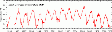 Another (St Paul's Island) which is mentioned in the text on the NOAA page.
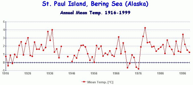 Why go with the one's you have choosen?
Secondly I've started to think that there is a regional aspect to the Arctic. What happens in the east isn't necessarily mirrored around Greenland. It seem possible to have a potitive ice anomaly in the east and negative in the west at the same time. It seems unlikely that one temp record in the Bering Sea is going to give insight into the whole Arctic ice extent.
Why go with the one's you have choosen?
Secondly I've started to think that there is a regional aspect to the Arctic. What happens in the east isn't necessarily mirrored around Greenland. It seem possible to have a potitive ice anomaly in the east and negative in the west at the same time. It seems unlikely that one temp record in the Bering Sea is going to give insight into the whole Arctic ice extent.
Prev 2358 2359 2360 2361 2362 2363 2364 2365 2366 2367 2368 2369 2370 2371 2372 2373 Next


