Climate Science Glossary

Term Lookup

Enter a term in the search box to find its definition.

Settings

Use the controls in the far right panel to increase or decrease the number of terms automatically displayed (or to completely turn that feature off).

Term Lookup

Settings


All IPCC definitions taken from Climate Change 2007: The Physical Science Basis. Working Group I Contribution to the Fourth Assessment Report of the Intergovernmental Panel on Climate Change, Annex I, Glossary, pp. 941-954. Cambridge University Press.

Home Arguments Software Resources Comments The Consensus Project Translations About Support

Twitter Facebook YouTube Mastodon MeWe

RSS Posts RSS Comments Email Subscribe


Climate's changed before
It's the sun
It's not bad
There is no consensus
It's cooling
Models are unreliable
Temp record is unreliable
Animals and plants can adapt
It hasn't warmed since 1998
Antarctica is gaining ice
View All Arguments...


Username
Password
New? Register here
Forgot your password?

Latest Posts

Archives

U.S. 2011: The Wet Get Wetter, the Dry Get Drier

Posted on 13 January 2012 by Tom Smerling

precipitation map

As the earth warms, “the rich get richer and the poor get poorer"--in rainfall.  

In 2011, over half the U.S. suffered either drought or delugeDr. Jeff Masters’ WunderBlog (12/12) summed it up:

“The combined fraction of the country experiencing either severe drought or extremely wet conditions was 56% averaged over the January–November period – the highest in a century of record keeping."

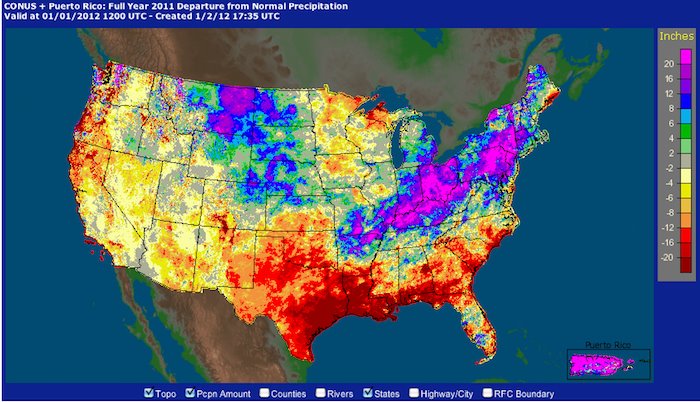
(Map courtesy of NOAA, via Jeff Masters and Heidi Cullen. Climate communicators:  Note the artful use of color.  The key information--orange drought areas and blue/fuschia wet spots--practically jumps off the screen.)

And the climate take-away?

"Climate change science predicts that if the Earth continues to warm as expected, wet areas will tend to get wetter, and dry areas will tend to get drier–so this year’s side-by-side extremes of very wet and very dry conditions should grow increasingly common in the coming decades.”

In a warming world, earth’s water cycle speeds up (See “Drought & deluge:  It’s the Water, Stupid!“).  Drought devastates agriculture; just ask Texas cattle ranchers.

After fast evaporation parches the South, prevailing winds blow the moisture-laden air northeastward.  The result for Northeastern states:     “When it rains, it pours.”   Masters notes that 2011 was “the wettest year in nearly 200 years of record keeping in Philadelphia, Pennsylvania.”  Weather.com adds that “at least 20 locations from the Ohio Valley to New England have set a new record wet year," shown in an interactive maps of towns that set new records for wet or dry conditions.

Masters concludes, “If you weren’t washing away in a flood, you were baking in a drought in 2011.”   

Was 2011 a “sneak preview” of our climate future?

(Cross posted from ClimateBites, 1/4/12)

0 0

Printable Version  |  Link to this page

Comments

1  2  Next

Comments 1 to 50 out of 51:

  1. Excuse me for being the most boring person on earth, but this is a reminder that we need to get serious not just about energy conservation, but also about water conservation. We were doing a lousy job of managing this precious resource before we decided to add climate change to the equation. The program: 1. Water efficient agriculture. 2. Market pricing for water. 3. Effective treatment and water recycling. 4. Overhaul of water rights -- system that recognizes water as a shared asset, like the atmosphere. 5. Ramped up storage of water for the inevitable droughts and to minimize draws from rivers and lakes during low-flow periods. 6. Planning for (where necessary) high-cost high energy solutions like desalinization. Note that fossil fuel burning can also be water-intensive. Charging a market price for water would bring us a step closer to fair market prices for fossil fuel energy.
    0 0
  2. Your last Masters quote is from his 11 Jan 2012 blog entry. A great illustration of the wet get wetter, the dry get drier: --source The numbers on this map are rankings of 'wettest' (high numbers) and 'driest' (low numbers). Seven states had their wettest year on record, and an additional ten states had a top-ten wettest year. Texas had its driest year on record, and four other states had a top-ten driest year. I actually heard someone wondering why 'they just don't build a pipeline for all that floodwater' to irrigate the drought-stricken.
    0 0
  3. I have to say that I take this prediction with a large grain of salt. I live in Southern California's high desert, and during El Nino conditions we get more precipitation on average. I know weather is quite the complex thing, but with warming oceans wouldn't that mean in my area we would get wetter, whereas Washington State would be getting drier which typically happens during El Nino years? Don't get me wrong, this doesn't mean I think it is a good thing to our flora and fauna, just a opinion of mine.
    0 0
  4. Aussie - are assuming that with warming earth that El Nino would be more common? This is unsettled science.
    0 0
  5. @ scaddenp - No I am not saying that at all.
    0 0
  6. @ AussieinUSA
    "but with warming oceans wouldn't that mean in my area we would get wetter, whereas Washington State would be getting drier which typically happens during El Nino years?"
    Not necessarily. Implicit in your statement is the presumption that the existing weather patterns will hold true in their geographic localities and in their existing seasons. We have already measured the northward migration of the ITCZ (Inter-Tropical-Convergence-Zone), the poleward expansion of the Hadley Cells and the anomalous WACCY (Warm Arctic, Cold Continents) weather in the Northern Hemisphere (NH). The demise of the Arctic sea ice is merely the thermometer telling the tale of the health of the NH's air conditioning system, itself at the heart of the main engine powering the NH circulatory systems. That engine, persistent in its current operational fashion for literally millions of years, is being forcibly shifted into a different functional norm. An ensemble of the models used by the IPCC, given the ongoing warming that simple physics tells us is already in the pipeline, tell us to expect continued drying: [Source]
    0 0
  7. @ Daniel Bailey - Thankyou for your excellent response.
    0 0
  8. Jeff Masters again: Percentage of the U.S. in extreme droughts or extremely wet, 1910-2011 Notice the red trendline, relative to the black horizontal mean for the period. A trend? Image and video hosting by TinyPic Figure 3. Percentage of the contiguous U.S. either in severe or greater drought (top 10% dryness) or extremely wet (top 10% wetness) during 2011, as computed using NOAA's Climate Extremes Index. Remarkably, more than half of the country (58%) experienced either a top-ten driest or top-ten wettest year, a new record. Image credit: NOAA/NCDC.
    0 0
    Moderator Response: [RH] Fixed image width.
  9. So, do you suppose that in 1970, when the wet-or-dry number was about 2%, that people were concerned that 'every where is just about average'?
    0 0
  10. #9: Which situation do you think is most stressful for plants, animals, people on flood plains, or people relying on limited water supplies? 1: Really average conditions, everywhere gets just about the amount of rain they typically expect. 2: Extremes of wet and dry with associated extreme drought and flood?
    0 0
  11. Oregon is looking better and better
    0 0
  12. Tom I would not put too much reliance on the trend line until we have a few more high years - at the moment it appears to be pushed up by one year's data. I can see a certain peer in a few years telling everyone that extreme weather events have been declining since 2011.
    0 0
  13. It is not strictly true that wet states get wetter and dry ones get drier. For instance Louisiana shows up as much below normal but this was the state that got dumped on by Catrina. What does appear to happen is that the wet extremes get wetter and the dry extremes get drier sometimes in the same place in different years. Given that I come from "a place of droughts and flooding rains" this does not augur well for me.
    0 0
  14. #12 @Sceptical Wombat I agree. That's why I posed it as a question -- Is there a trend? -- rather than a statement. I'd like to hear from some other statistics folks about this...
    0 0
  15. From a look at Tom Smerling's graph post at 8 it would seem that to form any long term conclusions about 2011 would be premature. There were only two year's in the 100 time span that had more than 50% of the United States in either a severe drought or too wet. And looking at the years before 2011 it certainly does not indicate any upward motion.
    0 0
  16. My question is why would one extreme year in an area that covers a small part of the globe mean anything or give any indication of potential change in the future? I have brought up short term changes on other threads. Here is the response. or this. SKS seems very critical of forming conclusion based upon very short times spans or relatively small areas.
    0 0
  17. Norman, SkS is simply saying this is indicative both of what has been predicted for AGW conditions, and what we can expect more of in the future. But you knew that already. You might have noticed there were just a few other droughts and - particularly - floods in other areas around the globe in the course of the last year or so. Along with the wombat I can also easily imagine an 'extreme weather events have been declining since 2011' meme arising, at least until the next major El Nino or La Nina. Then the decline will reset from that date.
    0 0
  18. Norman, I really think you need to read the SkS article Quantifying Extreme Heat Events and the linked paper by Hansen et al. There, you will see graphically how extremes of heat are on the rise, not only in the US, but all around the globe, just as predicted. with 10% of the globe now experiencing "extremely hot" conditions compared to <1% 50 years ago. The US is merely reflecting this global pattern; indeed in recent years the US has been quite lucky to avoid most of the great extremes until the Texas drought brought 3-sigma heat to US shores. 3-sigma heat is on the rise and is now a 1-in-10 chance for any given location and rising.
    0 0
  19. Extreme weather may not increase every year, but throughout the course of this century it is likely to. James Hansen's paper shows a marked increase in heat extremes in the last few decades, and the Rahmstorf & Coumou (2011) paper demonstrate the fundamental reasoning behind this. We also have Li (2011) who show that La Nina/El Nino seems to grow in intensity and frequency with warming of the background state of the Pacific Ocean. And a recent modeling study Seager (2011) showing not only will El Nino/La Nina intensify this century, but it should have started already. They maybe right. We humans are just going to have to get used to increasingly more wicked weather, and suffer the consequences. Of course, rapidly phasing out fossil fuels would stop things from becoming even worse. Just a thought.
    0 0
  20. Scotland had its wettest year on record with 73.2in (1859.5mm) of rain, beating a previous record set in 1990. However, some parts of England have had very low levels of rainfall, according to the Met Office. East Anglia had its second driest year on record with 17.6in (449mm) of rain and the Midlands its third driest with 23in (586.5mm). I think the UK rainfall changes last year are broadly in line with what the models suggest for us.
    0 0
  21. Norman "From a look at Tom Smerling's graph post at 8 it would seem that to form any long term conclusions about 2011 would be premature." Have another look at that graph. In particular run your eye across the 20ish% 'mean' level. Now do it again looking for 'above the mean' and 'below the mean' on the red trendline. When I do this, I notice that before 1980 the line oscillates above and below. After 1980? It went up. And has never gone below the mean since.
    0 0
  22. #15-16 Norman : From the graph in #8 (Tom), it seems there is a trend even without sophisticated statistics. Since 1980, 20 yrs are above the mean (black line), and since 1910, I see no other period of 3 decades with such a 2/3 rate. Even 1931-1960 period (with the highest previous bars) had 12 yrs above the mean, so 1/3.
    0 0
  23. Norman, When you don't keep up with what everyone else knows you make incorrect assertions. Skeptical Science has already had a post about worldwide increase in extreme heat events. Please read Quantifing extreme heat events as several other people have referred you to. The data on the USA is important because many readers, like me, live in the USA. This post describes the annual report from the National Climate Data center. The NCDC has not released the worldwide data yet. Expect a post soon describing the world situation. Skeptical Science is a good web site, but they have to wait for the data to be released before they can write a post.
    0 0
  24. @ Norman You continue to prosecute an agenda of "It's not happening" "It's natural variation" "there's not enough data" and to prop up the agenda you typically focus on short term events in local areas. Here's a global metric for you: Way back when I made this observation:
    "The last month with below-average temperature was February 1985. That makes 313 consecutive months with temperatures above the 20th Century average. Not that anyone expected that... Betcha that streak continues for some time."
    We are now at 322 consecutive months...and still counting. Whodathunkit? Regime change, anyone?
    0 0
  25. As I understand climate science, predicting precipitation is more difficult than temperature and regional forecasts are less certain than global forecasts. Predicting that wet areas in the US will get wetter and dry areas drier due to global warming should therefore be a lot more challenging than estimating the rise in global temperature by the end of this century. Could you provide an explanation why this regional forecast is reliable in more detail? The post states that "fast evaporation parches the South and prevailing winds blow the moisture-laden air northeastward". But why would global warming have this result. I could imagine that warmer temperatures would lead to more water evaporating off the Gulf of Mexico leading to more rain in the Southeast. The higher temperatures could mean more evaporation and less precipitation in the Northeast. I think this site needs to post something much more detailed on regional climate forecasting with regards to temperature, precipitation and prevailing winds, explaining how they work - without simply stating that that is what climate models predict. How reliable are they? What are their strengths and weaknesses? Cheers, Martin
    0 0
  26. 25, Martin, I don't know the answers to all of your questions, and as you say, making regional predictions is very, very tricky. But in reference to your specific question of why global warming should specifically make parts of the South more dry and areas further north more wet... as I previously commented here and here and in the rest of that thread... Very simply, the Earth has something called Hadley Cells. The sunlight strikes the earth most directly at the equator, which also is predominantly ocean. Thus the greatest, most continuous heating and evaporation occurs there. This hot air rises, carrying the moisture with it. Eventually it can't rise any further and spreads north and south (at high altitude). This continues as the air cools and eventually sinks. The result is that the moisture that is evaporated at the equator is carried over the the adjacent land and deposited further north (or south). If you look at a map of the Earth, you'll the the deserts predominantly occupy the same latitudes... those areas over which the Hadley Cells carry the moisture before depositing it. How is this affected by global warming? The forces behind the Hadley Cells get stronger. There is more evaporation, and the air is warmed more and travels higher and farther. This means that the arid area within the Hadley Cell grows, and the area at the far edge of the cell with the rain – more of it – moves further north. And, of course, the sun continues to strike that growing arid area, which coupled with the increased warmth serves to evaporate more water from that region which is also carried and deposited further north (or south). If you look at the provided image, find the "Horse Latitudes." Look at the deserts in North America that coincide with this (rainfall north, primarily arid south). Now imagine shifting that line further north. The predicted growth of the Hadley Cells with warming has already occurred (and we've barely experienced the warming we have already invoked and continue to invoke). Hence... global warming will cause the cells to grow, which will cause the deserts to expand, and the wet regions beyond them to become more wet. [Caveat: this is of course not the only mechanism in play. You can have a variations due to local geography, for example high mountain ranges like the Rockies, the Himalayas and the Andes which can block the flow of moisture or create arid conditions of their own simply with their altitude. But a simple look at a globe and the locations of the deserts demonstrates how dominant the effects of the Hadley Cells are in many regions of the earth.]
    0 0
  27. In addition to Sphaerica's response, Martin, you might try Lu, Vecchi, & Reichler (2007) for a basic physical mechanism and its relation to GCMs. A post on Hadley Cell changes, though, would be useful--and something Norman should investigate. Abstract of Lu (emphasis mine): "A consistent weakening and poleward expansion of the Hadley circulation is diagnosed in the climate change simulations of the IPCC AR4 project. Associated with this widening is a poleward expansion of the subtropical dry zone. Simple scaling analysis supports the notion that the poleward extent of the Hadley cell is set by the location where the thermally driven jet first becomes baroclinically unstable. The expansion of the Hadley cell is caused by an increase in the subtropical static stability, which pushes poleward the baroclinic instability zone and hence the outer boundary of the Hadley cell."
    0 0
  28. Sphaerica, 26 Thanks for your detailed answer. I clicked on the links you suggested. If I have correctly understood that Scientific American article the ITCZ will move north by 5 degrees (about 550 km) by 2100. I assume northern edge of the Hadley cell will do the same? It seems to me that the drought in Texas and the additional rain in the Northeast are much stronger than anything predicted for the beginning of this century, i.e. the rain has moved far further north than I would have expected. What quantitative predictions are made with regards to Hadley cell changes and precipitation for the previous and the current decade? DSL, 27 Thanks for pointing this paper out to me. I did start to read it but it contains too many terms that I'm not familiar with. So I don't think I really understood it. Perhaps you could explain why the Hadley cell is expanding poleward and weakening(!) I would have expected it to be strengthening. Sphaerica mentions that the forces behind the Hadley cell are getting stronger. Surely this means that the HC gets stronger as well?
    0 0
    Response:

    [DB] Please refrain from all-caps usage.  And also please familiarize yourself with the Comments Policy of this website.

    Thank you.

  29. Australia seems to be an extreme case of flood and drought. You would think that they could find a way to turn their occasional biblical flood inland to turn huge areas of their desert into an inland lake and recharge their water tables. It would be no larger a project in relation to the size and wealth of their society than what the Nabateans did in the Middle East 2000 years ago.
    0 0
  30. Thanks for the link to http://www.ncdc.noaa.gov/sotc/ The data supplied there indicates that out of the whole US, only 3 towns (all in Texas) had "record" driest years in 2011, and, 20 towns had "record" wettest years in 2011. The "records" of the 3 dry towns were 19-32% drier than the previous records. The records broken were all from 1970. The "records" of the 20 experiencing wettest years, were as follows: .01" - 2" above previous record - 8 towns (.02% - 3.2% over previous records). The previous records were from 1880, 1935, 1950, 1983, 1990, 1996, 1998, 2005. 2.01" - 5" above previous record - 8 towns (4.13% - 7.91% over previous records)The previous records were from 1911, 1935, 1952, 1983, 1983, 1989, 2004, 2008. 5.01" - 15" above previous record - 3 towns (10.61% - 21.34% over previous records)The previous records were from 1990, 1996, 2006 15.7" above previous record - 1 town (27.27% over previous records)The previous record was from 1990. Considering there are only 23 towns in total, in the US, that experienced either drier or wetter record years, I'm having difficulty in seeing how this data can be used to successfully predict any kind of a trend.
    0 0
  31. 28, Martin, I'm unaware of any quantitative predictions (they may be there, but I don't know of them). I'm not sure I'd put much value in them anyway. As I said, there are a whole lot of factors, from Hadley Cells and the ITCZ to mountain ranges (or low-lying land), oceans, ocean currents, etc. There's just too much to ever predict with our current understanding and modeling. On the ITCZ, though... I have to look more closely at the article. The ITCZ is a part of the Hadley Cell. It's that spot where the air rises. I was aware that the Hadley Cells would grow in width, but did not realize that they were saying the center – the ITCZ – would also shift north. That's yet another wrinkle in things. I'm actually unsure why it should shift north, because it primarily tracks the spot where the sun strikes the earth directly, at 90˚ at noon, which is why it shifts north and south with the seasons. I'll have to research this some, when I have time.
    0 0
  32. I'm not sure how meaningful figure 3 in the Jeff Masters link is (from link in post 8). The red line does waver above the black line a bit more lately, but it should end in 2006 at a level less than the 30's or 50's. 2011 was certainly an interesting year weatherwise, but the climate factors were unusual (strong La Nina that weakened more rapidly than usual). The La Nina is not very strong now and some weather factors are inducing closed lows in the desert SW alleviating the Texas drought. The end of 2011 was definitely not wet getting wetter and dry getting drier, but the opposite.
    0 0
  33. Eric @32, "The end of 2011 was definitely not wet getting wetter and dry getting drier, but the opposite. That is not quite true, here is the PDSI for the fall (September through November 2011): Still dry in the Red River valley, still areas of drying in the southern Great plains, especially Texas. Still wet over the northeast and Ohio river valley. Things did improve over Texas in December, but even by January 10 2012 almost all of Texas was still in drought, with large areas classified as "extreme" or "exceptional" drought.
    0 0
  34. Albatross, my point is that despite a climate factor against the remoistening of Texas (La Nina), the weather did so anyway. OTOH the map you linked above shows an eastward shift in the northern precipitation band, certainly some areas in the midwest that were wet got wetter, but areas to the east (like mine in Northern Virginia) got wetter after a dry summer. The patterns shift and what can be said about possible climate change influences is that they will exacerbate extremes especially in summer where, in particular, the hot and dry places get hotter and drier. But a blanket statement like the title of this article will almost certainly be countered with pattern changes in the coming year (like the unexpected series of upper lows in the desert SW). Climate change will not result in particular precipitation patterns as the post implies, it will have more of an amplifying effect, at least for now.
    0 0
  35. Some interesting data from Munich Re - one of the worlds major re-insurers - wrt frequency of catastrophic events: Note how its all Climate related wrt the increase. Geophysical events such as Earthquakes fluctuate but stay stable
    0 0
  36. "You would think that they could find a way to turn their occasional biblical flood inland to turn huge areas of their desert into an inland lake and recharge their water tables." What do you think Lake Eyre and the Great Artesian Basin are? Lake Eyre has filled 3 years in a row. You might think this is entirely predictable and unremarkable. Well, you should note that in the first of those 3 years a lot of people changed all their plans and spent a lot of money to get there and see it - because they thought it was the last chance they'd get in their lifetimes. Filling at all is unusual. Filling twice is extremely unusual. 3 times in a lifetime? Probable but not to be relied on. 3 years straight - unheard of.
    0 0
  37. Glenn Tamblyn @35 The lack of increase in reports of Geophysical catastrophes appears to be inconsistent with the claims made by some "skeptics" that we are simply reporting more catastrophes, not that there are more. If humanity were becoming more sensitive and reporting more events as catastrophic then why hasn't the Geophysical figure increased in line with the others ?
    0 0
  38. Eric#34: "despite a climate factor against the remoistening of Texas (La Nina), the weather did so anyway." Not so fast. the National Weather Service issued its latest Seasonal Drought Outlook, for the period from Jan. 5 through March 31, which featured a map showing persistence of drought conditions across virtually all of Texas, with “some improvement” expected in a small sliver of the northeast corner of the state and “drought development” in four remaining and smaller areas in North Texas and the Panhandle. --source, the 5 January US Seasonal Drought Outlook (link may point to an updating map) As the man said, "It ain't over 'til it's over."
    0 0
  39. saltspringson#30: "only 23 towns in total, in the US, that experienced either drier or wetter record years" What is the significance of town by town analysis? By the map shown here, 7 states had record wettest (two more near-record wettest) and Texas as a whole (a rather large area) had its record driest during 2011. On a closer look, this map shows SPI within states for the last 12 months. --source There are quite a few 'towns' in the black (exceptionally dry) and many more in the purple (exceptionally moist); whether they set new records or not makes little difference when your pastures are either burned up or flooded out.
    0 0
  40. Muoncounter, it's generally true we won't know what will happen but it's also a fact that the skill of the forecast that you show has dropped to practically zero (coin toss) during this La Nina: text file and explanation and parent page. Those forecasts do pretty well during stable ENSO states, especially El Nino, but not as well during transitions and La Nina, probably because the position of the jet streams is more difficult to predict.
    0 0
  41. 26, Spherica you wrote
    "The result is that the moisture that is evaporated at the equator is carried over the the adjacent land and deposited further north."
    That seems to contradict what I read about the Hadley cell at wikipedia here "Having lost most of its water vapor to condensation and rain in the upward branch of the circulation, the descending air is dry." I still haven't understood why the Northeast is becoming wetter.
    0 0
  42. Hi, I have found something mentioning why the dry is getting drier and the wet getting wetter here.
    "As the planet warms, the Hadley Cell, which links together rising air near the Equator and descending air in the subtropics, expands poleward. Descending air suppresses precipitation by drying the lower atmosphere so this process expands the subtropical dry zones. At the same time, and related to this, the rain-bearing mid-latitude storm tracks also shift poleward. Both changes in atmospheric circulation, which are not fully understood, cause the poleward flanks of the subtropics to dry."
    I still think that a new post giving a fuller explanation why this is happening would be great. Perhaps one of this site's regular authors could put this topic on his or her short list for 2012?
    0 0
  43. 41, Martin, You are right. I appear to have misunderstood some of the Hadley Cell mechanics. I'll have to look at it more closely. Mind you, as I said before, the Hadley cell is only part of the picture. Water of course is evaporating, rising, and condensing in places other than the equator, so any wind/rain patterns that already exist (such as those relating the Pacific and the US Northwest) are likely to be amplified, unless they are also drastically changed in a way somewhat similar to Hadley Cell growth so that the location of the rainfall changes along with the amount. There are lots and lots of other mechanisms to look into.
    0 0
  44. Phil @37 Yep, it is inconsistent with the claim made by skeptics. Or another way of saying it, what the skeptics claim is wrong. There are more catastrophic events, weather/climate related. And the organisation reporting it has zero reason to misrepresent or spin the results.
    0 0
  45. Martin - Perhaps nobody understands it. Climate change computer models are much better at projecting temperature than they are precipitation. (Rather like the 10-day weather forecasts. Temperature predictions tend to be more accurate than rain, which is pretty useless more than a few days out, even though they still make the 10-day forecast.)
    0 0
  46. 45, Joe According to what I have been reading th "wet is getting wetter and dry ist getting dryer" is a very robust result, i.e. almost all models show this behaviour. What I'm looking for is an explanation that I can understand.
    0 0
  47. 39 muoncounter You stated, "What is the significance of town by town analysis? By the map shown here, 7 states had record wettest (two more near-record wettest) and Texas as a whole (a rather large area) had its record driest during 2011." There is no mention of the word "record" either in the mapping or at the source you quote. My point is when someone uses the word "record" as being an indication of things getting hotter or colder, it behooves us to look at whether the number of "records" are significant or not. It appears from the data I quoted, that there was not a significant number of "records" for 2011. If a "record" drought was occurring, over a widespread area (e.g. number of towns) for a number of years, that would possibly indicate a trend. 23 towns in all of the US with "records" is insignificant in my opinion.
    0 0
  48. saltspringson "There is no mention of the word "record".." If you ever want to keep on top of "records" set for the USA I can recommend Capital Climate which devotes most postings entirely to records. Just check out the posting for January 2012 so far. The neat little graphic on the left gives you a running total of records set for the current year.
    0 0
  49. saltspringson, you wrote on another thread : "A Google news search for "record cold temperature" for the past week gives 29 results. "Record high temperature" 9 results.". So far, adelady (above) has pointed you towards Capital Climate (which is showing 312 high records already this year in America, and 19 records for Jan the 9th alone), so I will just point you towards mherrera.org, (which also shows records for all countries each year since 2002), where you will see 7 of the 8 records so far this year are for maximums, not minimums. Do you have more details of the records you found on your Google search ?
    0 0
  50. saltsprings#47: "no mention of the word "record" either in the mapping or at the source you quote." Really? The linked NOAA map clearly displays state-by-state rankings of wettest and driest for the year. '#1' on that map would be record driest and '#117' would be record wettest.
    0 0

1  2  Next

You need to be logged in to post a comment. Login via the left margin or if you're new, register here.


The Consensus Project Website

THE ESCALATOR

(free to republish)


© Copyright 2024 John Cook
Home | Translations | About Us | Privacy | Contact Us