A Rough Guide to the Jet Stream: what it is, how it works and how it is responding to enhanced Arctic warming
Posted on 22 May 2013 by John Mason
Barely a week goes by these days in the Northern Hemisphere without the jet stream being mentioned in the news, but rarely do such news items explain in detail what it is and why it is important. As a severe weather photographer this past 10+ years, an activity which requires successful DIY forecasting, I've had to develop an appreciation into what makes it tick. This post, then, is a start-from-scratch primer based on that knowledge plus some valuable assistance from academia into where the current research is heading. Because of its length and breadth of coverage, I've broken it up into bookmarked sections for easy reference: to come back here click on 'back to contents' in each instance.
Contents:
Earth's Troposphere - an introduction
Weather systems aloft - the Polar Front and the jet stream
Waves on the jet stream - upper ridges and troughs
Positive vorticity - a driver of severe weather - and the jet stream
Wind-shear - a driver of severe weather - and the jet stream
Jetstreak development along the jet stream - a driver of severe weather
Northern Hemisphere atmospheric circulation patterns: the Arctic and North Atlantic Oscillations
Climate change and the future: how will the jet steam and pressure-patterns respond?
Earth's Troposphere - an introduction
We live at the bottom of a soup of gases, constantly moving in all directions - our atmosphere. Virtually all of our tangible weather goes on in its lowest major division, the Troposphere. This division varies in average thickness from about 9000m over the poles to 17000m over the tropics - in other words, it's thinnest in cold areas and thickest in hot areas, because hot air is more expansive than cold air. Likewise it fluctuates in thickness on a seasonal basis according to whether it's warmer or colder. Above it lies the Stratosphere, while below it lies the surface of the Earth.
The junction with the Stratosphere is known as the Tropopause and as the diagram below shows, it is a major temperature inversion: although it gets colder with height in the Troposphere, at the Tropopause it suddenly warms. The inversion is so strong that convective air currents, which involve parcels of warm air rising buoyantly through cooler surroundings, fail to penetrate it. That is why the flat, anvil-shaped tops of convective cumulonimbus (thunderstorm) clouds spread out laterally beneath the Tropopause, as though it were some ceiling in the atmosphere.
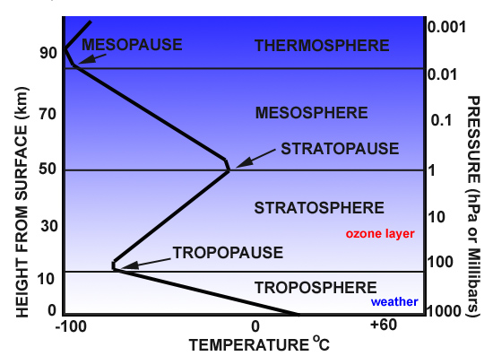
above: section through the lower 100km of Earth's atmosphere. The thick black zigzagging line plots typical changes in temperature from the surface upwards; height above surface is the LH scale and typical pressure with that height is the RH scale.
The Troposphere, which this post concerns, can be divided into two subsections: an upper layer, known as the Free Atmosphere, and a lower layer, known as the Planetary Boundary Layer. The Boundary Layer usually runs up from the surface to about 1000m above it (sometimes a bit more, sometimes a bit less) but basically it's a relatively thin layer in which the air movements and temperatures are influenced not only by major weather patterns but also by localised effects relating to the interaction of the air with the planet's surface. Such effects include frictional drag as winds cross land areas, eddies, veering and lifting due to hills and headlands and convection initiated directly by heat radiation from sun-warmed ground. Low-level air currents, such as the cool sea-breezes that push inland from coasts on warm summer days, likewise aid and abet convection and thereby thunderstorm formation as they undercut and lift warmed airmasses along zones of convergence - where different air-currents come together. These factors are all low-level forcing mechanisms that set air currents in motion or perturb existing currents.
Above the Boundary Layer, winds are directed by two factors: the gradients that exist between centres of high and low pressure (anticyclones and cyclones respectively) - air will always flow from a high-pressure zone to a low-pressure zone - and the modifying factor known as the Coriolis Effect, which is the force exerted by the Earth's rotation. In the Northern Hemisphere, it causes airmasses to be deflected to the right of their trajectory and this effect is strongest at the poles and weakest at the Equator. In the Northern Hemisphere, the effect is to make the winds around a high pressure centre circulate in a clockwise manner and those around a low pressure centre circulate in an anticlockwise manner: on a larger scale, the Coriolis Effect helps to maintain the prevailing west-to-east airflow.
Although the weather-charts seen on TV forecasts show only what is happening close to the surface, the forecasts themselves are made with much reference to goings-on in the upper Troposphere. In upper-air meteorology, pressure-patterns are as important as they are down here at the surface. Atmospheric pressure is simply an expression of the force applied by a column of air upon a fixed point of known area, and is measured in pascals (Pa). Meteorologists use the hectopascal (hPa) because the numbers are the same whether expressed in hectopascals or the older unit, millibars.
The greater the altitude, the lower the atmospheric pressure - because there's less air above. In meteorology, above-surface observations are made remotely with satellites and directly by weather-balloons carrying measuring instruments. The results of the balloon ascents, called soundings, are plotted on charts at different pressure-levels, some typical examples of which are as follows:
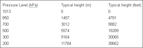
Pressure at any given height can change quite drastically as weather-systems move through, just as it does at the surface. Taking the UK as an example, as an Atlantic low-pressure system moves through and is then replaced by a large high-pressure area, the pressure over a few days at sea-level can rise from 970 hPa to 1030 hPa. The same applies aloft, but unlike surface charts, where the data are plotted in terms of pressure, the upper air data are plotted in terms of geopotential. Geopotential is the height above sea-level where the pressure is, say, 850, 500 or 300 hPa, and is measured in Geopotential Metres (gpm or gpdm).
Other properties of the upper air, such as temperature, are important too. For example, storm formation in an unstable lower troposphere is markedly encouraged if cold dry air is present aloft, which makes the rising warm moist air much more buoyant, increasing the instability. Storm forecasters will look at soundings for indications that cold upper air is either already present or is upwind and can be expected to be transported into the forecast area. The process by which air (with its intrinsic physical properties such as temperature or moisture content) is transported horizontally is known as advection, an important term that will appear elsewhere in this post.
Weather systems aloft - the Polar Front and the jet stream
The interaction of warm tropical and mid-latitude air and cold polar air is what drives much of the Northern Hemisphere's weather all year round. For a variety of reasons, the change in temperature with latitude is not gradual and even, but is instead rather sudden across the boundary between mid-latitude and polar air. This boundary, between the two contasting airmasses, is known as the Polar Front. It is the collision-zone where Atlantic depressions develop and their track is largely directed by its position. The steep pressure-gradients that occur aloft in association with this major, active airmass-boundary result in a narrow band of very strong high-altitude winds, sometimes exceeding 200 miles per hour, occurring just below the tropopause. Such bands occur in both hemispheres and are known as jet streams. The one in the Northern Hemisphere, associated with the Polar Front, is often referred to as the Polar jet stream. The greater the temperature contrast across the front, the stronger the Polar jet stream: for this reason it is typically strongest in the winter months, when the contrast between the frigid, sunless Arctic and the midlatitudes should normally be at its greatest.
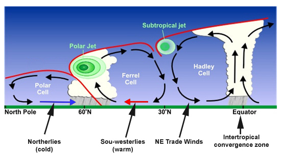
above: section through the atmosphere of the Northern Hemisphere. Air rises at the Intertropical Convergence Zone and circulates northwards via the Hadley and Ferrel Cells (sometimes separated by a relatively weak Subtropical jet stream) before meeting cold Polar air at the Polar Front, where the Polar jet stream is located. Graphic: NOAA.
Waves on the jet stream - upper ridges and troughs
The Polar jet stream is readily picked out on upper-air wind charts, as in the example below. This is a Global Forecasting System (GFS) forecast model chart for windspeeds and direction of flow at the 300 hPa pressure level; in other words at an altitude a little higher than the summit of Everest and not far beneath the Tropopause. Highest winds are red, weakest blue. The most obvious thing that immediately catches the attention is that the jet stream doesn't always run in a straight, west-east line, even though that's the prevailing wind direction in the Northern Hemisphere.
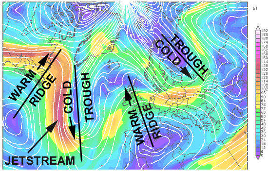
Graphic: model output plot - Wetterzentrale; annotation: author
Instead, it curves north and south in a series of wavelike lobes, any one of which can half-cover the Atlantic. These large features, which are high-pressure ridges and low-pressure troughs, are known as Longwaves or Rossby Waves, of which there are several present at any given time along the Polar Front. A key ingredient in their formation is perturbation of the upper Troposphere as the air travels over high mountain ranges, such as the Rockies. Warm air pushing northwards delineates the high-pressure ridges. Cold air flooding southwards forms the low-pressure troughs. The two components to jet stream flow - west-east and north-south - are referred to as zonal and meridional flows respectively. The straighter a west-east line the jet stream takes, the more zonal it is said to be. The greater the north-south meandering movement, the more meridional it is said to be.
In addition to the Longwaves, there are similar, but much smaller ridges and troughs, known as Shortwaves. The chart above also shows how, locally, the jet stream can split in two around a so-called cut-off upper high or low, reuniting again downstream. Longwaves, shortwaves and cut-off highs and lows all have a strong bearing on the weather to be expected at ground-level.
Several factors are important with regard to the Polar jet stream and its effect on weather. Again taking the UK as an example, the position of the Polar jet stream is of paramount importance. If it sits well to the north of the UK, residents can expect mild and breezy weather, and occasional settled spells. The Atlantic storms are passing by to the north, so they only clip north-western areas. However, if the Polar jet stream runs straight across the UK then the depressions will run straight over the country, with wet, stormy weather likely. If it sits to the south, depressions take a much more southerly course, bringing storms to Continental Europe, and, in winter, the risk of heavy snow for the southern UK, as the prevailing winds associated with low pressure systems that are tracking to the south of the UK will be from the east, thereby pulling in colder continental air.
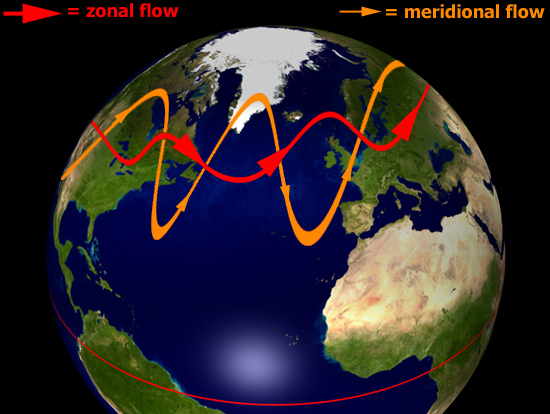
above: typical zonal (red) and meridional (orange) jet stream paths superimposed on part of the Northern Hemisphere. Extreme meridionality can bring very cold air flooding a long way south from the Arctic while warm air is able in a different sector to force its way into the far north. The most extreme version of this I have seen was on the morning of November 28th 2010: at 0600, parts of Powys (Mid Wales) were down to -18C, whilst at the same time Kangerlussuaq, within the Arctic Circle in Western Greenland, was at +9C - or 27C warmer!! Graphic: author
In highly zonal conditions, weather-systems move along rather quickly, giving rise to changeable weather. However, in highly meridional conditions, the Longwaves can slow down in their eastwards progression to the point of stalling, to form what are known as blocks. When a block forms, whatever weather-type an area is experiencing will tend to persist. During some winters, for example, a blocking ridge forms in the mid-Atlantic, with high pressure extending from the Azores all the way up towards Greenland. Provided the block is far enough west, it can induce a cold northerly to easterly airflow over NW Europe, a synoptic pattern that brings cold weather and, in recent winters, heavy snowfalls.
Now, let's move onto some of the important weather-forcing mechanisms that are associated with the jet stream and its wave-patterns.
Positive vorticity - a driver of severe weather - and the jet stream
Another important factor associated with any jet stream is vorticity advection. The jet flowing around a lobe of cold polar air (an upper Longwave or Shortwave trough), orientated north-south, first runs S, then SE, then E, then NE, then N - i.e. its motion is anticlockwise, or cyclonic. Watch a floating twig in a slow-moving river. As it turns a bend it will slowly spin. It's spinning because the water upon which it floats is spinning - it has vorticity. You can't necessarily see the water doing this but the floating twig gives the game away! Vorticity is a measure of the amount of rotation (i.e. the intensity of the "spin") at a given point in a fluid or gas. And, in the air rounding an upper trough, anticlockwise vorticity is induced. This is known as Cyclonic Vorticity (or frequently as Positive Vorticity).
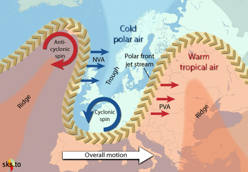
above: how the eastwards progression of upper ridges and troughs affects vorticity which in turn affects lift in airmasses. Areas of positive vorticity advection (PVA) occur ahead of approaching troughs, aiding severe weather development, whereas areas of negative vorticity advection (NVA) cause air to sink, inhibiting developments. Graphic: jg.
Positive vorticity in the upper Troposphere encourages air at lower levels to ascend en masse. Rising air encourages deepening of low-pressure systems, assists convective storm development and so can lead to severe weather such as heavy precipitation and flooding. As an upper trough moves in, air with positive vorticity is advected ahead of its axis in the process known as positive vorticity advection, usually abbreviated to PVA. Thus, to identify areas of PVA when forecasting, look on the upper air charts for approaching upper Longwave or Shortwave troughs: PVA will be at its most intense just ahead of the trough and that is where the mass-ascent of air will most likely occur.
The reverse, anticyclonic or negative vorticity advection (NVA) will occur between the back of the trough and crest of an upper ridge, due to the same process but with a clockwise (anticyclonic) spinning motion induced into the air as it runs around the crest of the ridge. In such areas air is descending en masse instead of ascending. Descent is very adept at killing off convection and cyclonic storm development. Thus as the upper trough passes, severe weather becomes increasingly unlikely to occur.
Wind-shear - a driver of severe weather - and the jet stream
Wind-shear, involving changes in wind speed and/or direction with height, is an important factor in severe weather forecasting. Shear in which windspeed increases occur with height (speed-shear) is common, as you will notice when climbing a mountain: a breeze at the bottom can be a near-gale at summit-level. But in the upper troposphere the proximity of the Polar jet stream can lead to incredibly strong winds. Speed-shear is important in convective storm forecasting as it literally whisks away the "exhaust" of a storm, thus helping to prolong it: the storm's updraught and precipitation-core (downdraught) are kept apart, instead of the downdraught choking the updraught. It's a bit like an open fire drawing well. The strongest speed-shear occurs when the jet is racing overhead. In this environment, cumulonimbus anvils may stretch for many miles downstream due to the icy cirrus of the anvil being dragged downwind. When there's hardly any speed-shear the storm-tops have a much more symmetrical shape to them.
Directional shear basically means that winds are blowing in a different directions at different heights from the surface. Drawing from my experience in weather-photography, I know that a warm early summer's day where the synoptic pressure-pattern gives a light northerly airflow at say 850 hPa, coupled with some instability, is a consistently productive set-up for thunderstorms and funnel-clouds. Why? Well, I live ten miles due east of the Welsh coast, surrounded by hill-country. As warm sunlight heats the lower Troposphere over the hills, air will begin to rise by convection: at the same time, a sea-breeze will set in, flowing west to east inland from the coast. These two air-currents will meet - or converge - along a linear front somewhere over the hills. Because the sea-breeze is relatively cool, along the front it undercuts and lifts the warm air, strongly aiding convective storm initiation. In addition, the developing storms are moving north-south along their steering flow but the air flowing into the western side of their updraughts - the sea-breeze - is coming in at right angles to that. That's a lot of low-level, rotation-inducing directional shear, more than sufficient for funnel-cloud development, something I have witnessed along sea-breeze fronts on a number of occasions.
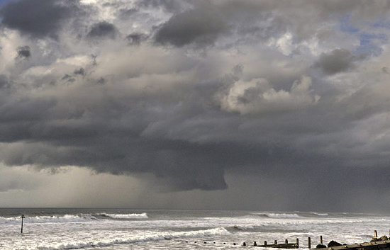
In situations where major instability (and therefore the potential for severe storms) is present, directional shear can be of critical importance in the formation of tornadic supercells, in which the updraught is rotating strongly from near ground-level all the way up to the top of the storm-cloud. These tend to be the most violent members of the thunderstorm family because of the persistence and strength of their updraughts.
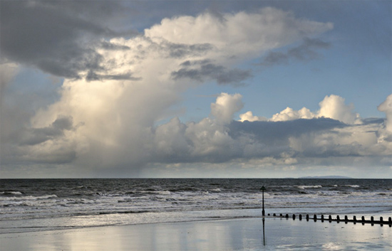
above: speed-shear revealed by a convective shower-cloud. High-speed upper winds are dragging the upper parts of the cloud well over to the R.
below: speed and directional-shear revealed by a small supercell thunderstorm: the updraught is tilted R-wards so that the rain is falling well over to the R, several miles downwind from the updraught base. The seat of the updraught is indicated by the dramatically lowered rotating wall-cloud reaching halfway down to the sea from the overall cloud-base. This storm persisted for over 90 minutes as it tracked across over 100km of the seas and mountains of Wales. Photos: author.
Jetstreak development along the jet stream - a driver of severe weather
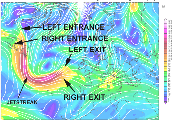
Within the overall, circumglobal ribbon-like wind-field of the Polar jet stream, there occur local sections with much stronger winds than elsewhere. These are called jetstreaks. They form in response to localised but major temperature-gradients, and they move around the lobes, following the troughs and ridges, and affect these in their passing, strengthening them as they move in and weakening them as they move out. They also influence the weather below even if moving in a fairly straight line when there are few longwave ridges/troughs about.
Graphic: model output plot - Wetterzentrale; annotation: author
Fast jetstreaks with winds as high as 200 knots pull in air upstream (to their west) at what is called an Entrance Region and throw it out downstream (to their east) at what is called an Exit Region. These are further subdivided, as in the diagram above, into Left (to the north) and Right (to the south). Because the behaviour of air currents is determined by the interaction of the Coriolis effect and the pressure-gradient, the Right Entrance and Left Exit regions of jetstreaks are areas where winds aloft diverge, allowing air below to rise. This in turn further encourages storm development. In Right Exit and Left Entrance regions, the opposite occurs, with upper-level winds converging leading to air sinking and inhibiting storm formation. The reason why, in terms of storm development, it is divergence as opposed to convergence that is important at height (the opposite being the case at low levels) is because converging air at height cannot go upwards because of the effective ceiling provided by the Tropopause. There is only one vertical direction in which the air can freely go - downwards.
What this means on the ground is that if your area is near to a developing low pressure system or a convectively-unstable airmass and an upper trough is approaching, with a jetstreak heading towards the base of the trough with its Left Exit region heading straight for where you are, you have the ingredients for explosive severe weather development. The low can deepen intensively to bring a storm system with tightly-packed surface isobars giving severe gales and flooding rains. Alternatively, convection may lead to the development of severe thunderstorms, because that critical combination of mass-ascent and high shear is in place.
Northern Hemisphere atmospheric circulation patterns: the Arctic and North Atlantic Oscillations
Atmospheric pressure-patterns in the Northern Hemisphere feature several semipermanent features and patterns. By semipermanent I mean that areas of high and low pressure are normally to be found in certain places or that pressure-patterns tend to switch from one type to another and then back. The low pressure of the Intertropical Convergence Zone is a good example of a semipermanent feature - it is normally close to the Equator but it is not always in the same place: it can shift a little north or south in its position. A good example of a switching pressure-pattern occurs in the Arctic and is known as the Arctic Oscillation (AO). When atmospheric pressure over the Arctic is low and pressure over the mid-latitudes is high, the AO is said to be in its positive phase, which supports a tight and fast-moving zonal, west-to-east airflow - the Polar Vortex - as the diagram below shows:

Graphic: author
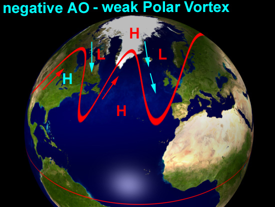
The next diagram is an example of what happens when the Arctic Oscillation is in its negative phase, with high pressure over the Arctic:
Graphic: author
The flow becomes more meridional, with big meanders occurring in the longwave ridges and troughs, which then tend to move eastwards much more slowly. Rossby Wave theory predicts this but there is a simple analogy: think of a river's flow weakening as it leaves the mountains and enters the lowlands, where it becomes sluggish and meanders develop and propagate seawards along the flood plain over many decades. A negative Arctic Oscillation pattern with these high-amplitude longwaves has the effect of permitting warm air to penetrate much further north (in the ridges) and cold air to plunge much further south (in the troughs), something that is obviously of relevance in the resultant weather-conditions.
The North Atlantic Oscillation is a numerical index that describes the average difference in surface air pressure between Iceland and coastal S Europe (the data sources used are Reykjavík in the north and either the Azores, Portugal or Gibraltar in the south). Although daily data are available, the NAO is typically expressed in monthly or seasonal terms.
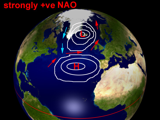
Here's the NAO in its positive phase:
Graphic: author
With a positive NAO, the Atlantic pressure-pattern essentially features a dipole, with low pressure over Iceland (the Icelandic Low) and high pressure off the Iberian coast (the Azores High). These are both good examples of semipermanent features - if they were not so commonplace they would not have been so named. South of the Icelandic Low, the sou-westerlies blow mild air and moisture towards NW Europe whilst SW of Iberia, on the southern flank of the Azores High, we find the north-easterly Trade Winds so important to merchant shipping back in the days of sail.
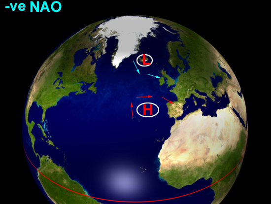
Now let's see a slightly negative NAO:
Graphic: author
The low and high pressure centres are still there but are both much weaker, leading to a strongly reduced pressure-gradient between the two and a slacker airflow. With the sou-westerlies much suppressed, colder winter weather can develop more easily over NW Europe. But what happens if the NAO is strongly negative, as it was during the cold spell of March 2013 when it dipped at one point to a phenomenal value of -5 (typical values are between +2 and -2)?
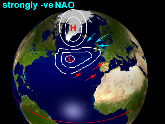
Graphic: author
The normal pressure-pattern is reversed: pressure over Greenland and Iceland is high whilst the mid-Atlantic is dominated by low pressure. In winter, this has the effect of vigorously pulling in moisture from the Atlantic but also cold air from either northern or eastern sources, a mixture which can lead to severe weather developing: the pressure pattern in the diagram is similar to those of both January 9th 1982 and March 22nd 2013, dates that have gone down in UK weather history for the unusually severe blizzards that occurred. The March 2013 blizzards were disastrous: it was very late in the winter to have such cold over here and the losses to farmers of livestock have been significant, with drifting snow having buried sheep, cattle and ponies to a depth of five metres or more in places.
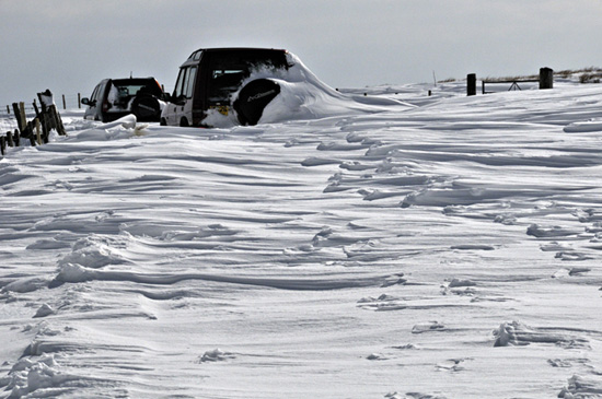
above: the late March 2013 blizzards struck parts of the UK with a fury not seen in decades. A strongly negative NAO/AO with blocking patterns in the jet stream can bring a complete spectrum of weather extremes and this is just one of them. This was on March 29th, a week after the storm occurred. Photo: author.
A further pressure-pattern that has been recognised in recent years, and has been linked to the rapid warming of the Arctic, is the Arctic Dipole:
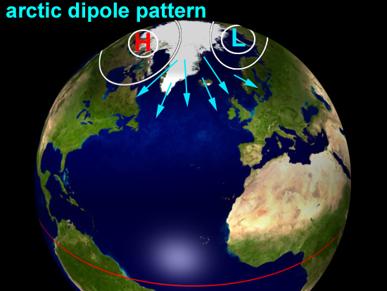
Graphic: author
In the Dipole pattern, high pressure sits over the Canadian side of the Arctic and low pressure sits over the opposite, Siberian, side. This setup has some similarity to a negative Arctic Oscillation phase in that the strong west-east zonal flow is not supported but, more importantly, two things are facilitated: cold air is churned out on the North Atlantic side of the system and may flood southwards for great distances but conversely warm air is pulled into the Arctic on the Pacific side. The Dipole pattern is thus a major heat-exchanger between the Arctic and the mid-latitudes.
The Arctic and North Atlantic Oscillations tend to behave in step with one another, as the following superimposed plots show:
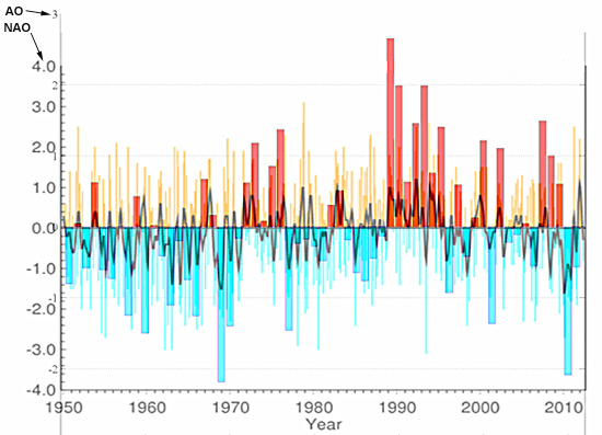
Data source: http://www.cgd.ucar.edu/cas/jhurrell/indices.data.html#naostatdjfm
In the plots, the thin lines are the NAO (with a black trendline denoting the moving average) and the bars the AO. It is apparent that there are periods dominated by either positive or negative values in both indices: the 1990s were strongly positive whereas the late 2000s, which have featured several very cold winters, have seen many and often strongly negative excursions.
Climate change and the future: how will the jet steam and pressure-patterns respond?
Wave theory tells us that the west-east progression of the Rossby waves is influenced by their size: larger waves move more slowly. Negative NAO/AO setups promote such meridionality and, according to recent research, that meridionality seems to be on the increase. A possible cause of this effect is the warming of the Arctic which has become so profound (twice that of the rest of the world) that it has been given a term: Arctic Amplification. Arctic Amplification manifests itself not only in the temperature record but also in physical features like the strong and in 2012 record-shattering seasonal melting of Arctic sea ice, a process which itself leads to more accumulation of heat energy as the ice-free sea-water absorbs incoming solar radiation that would have otherwise been mostly reflected back out into space.
Further heat, independant of sea ice or snow-cover, is transported into the Arctic by the increased global water-vapour content of the atmosphere, a factor that has three effects. Firstly, water vapour is of course a potent greenhouse gas: secondly, as moist air cools as it comes into the Arctic the water vapour condenses, releasing latent heat; and thirdly condensation forms clouds, increasingly regarded as heat-trapping agents. Such warming is particularly important in the sunless winter months and at higher atmospheric levels: at 500hPa and above it is the major component of Arctic Amplification, compared to the loss of albedo due to melting sea ice and snow close to the surface. Arctic Amplification is a relatively new phenomenon which has emerged as a signal in recent years: how it will interact with variations in existing circulation-patterns like the NAO/AO, ENSO (the El Nino-La Nina oscillation) and the PDO (Pacific Decadal Oscillation) remains to be fully understood. However, in a system full of variables, it generally holds that if major variables undergo major changes there will be knock-ons elsewhere in the system.
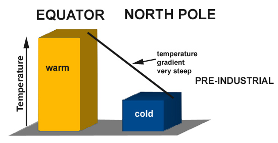
above: a very simplified diagram of how things were prior to Arctic Amplification, with a steep temperature gradient between the warm Equator and the cold Arctic. below: the situation now - while the low and mid latitudes have warmed a bit, the Arctic has warmed a lot. As a consequence, the temperature gradient between the two has a gentler slope. Graphic: author
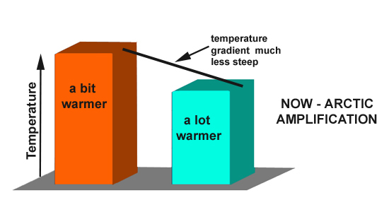
As the simple diagram above shows, one consequence of Arctic Amplification is to reduce the temperature-gradient between the Arctic and the warmer latitudes. Given that the strength of the jet stream is influenced by the magnitude of the temperature-gradient, it follows that warming of the Arctic could lead to a weakening of the jet stream and a greater tendency to meander as it slows down. As this meandering develops, troughs may be expected to extend further southwards and ridges to push further northwards. However, recent research suggests a greater northwards component to this behaviour (the ridges are pushing further northwards than the troughs are nosing southwards), meaning that in overall terms the Polar jet stream has moved northwards. The wavier state of the jet stream also causes more mixing of warm and cold air in the Northern Hemisphere. More importantly, situations where the eastwards progression of these upper waves becomes sluggish or stalls lead to prolonged weather-conditions of one type or another. Unseasonably cold, wet, hot or dry conditions that last for weeks at a time can be just as destructive as storms: their effects on biodiversity and agriculture can be disastrous, leading variously to reduced crop yields, crop failure, biodiversity loss and wildfires, to name but a few effects.
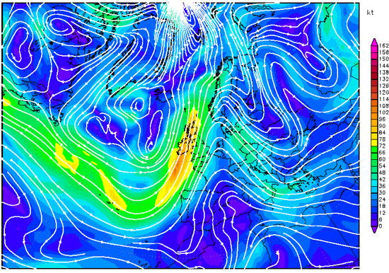
Recent research into the Polar jet stream has been focused on the 500hPa height/windfield, because for a number of reasons it is easier to work with. This lies below the height of the strongest jet stream winds, but a look at the charts below, 300hPa windfields above and 500hPa windfields beneath, shows that the tightest gradients and strongest winds are colocated.
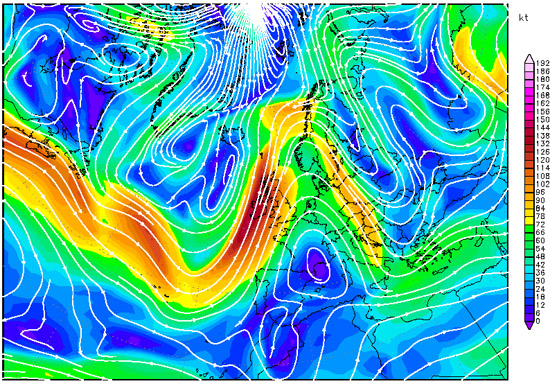
above: 300hPa windfields for April 14th 2013, 0600z. below: plot for the same date and time at the 500hPa level. The tightest gradients and strongest winds occur in the same places, meaning the 500hPa pattern can be used to make deductions about the 300hPa pattern. Model output plot - Wetterzentrale
The research has indeed found a correlation between 500hPa height autumnal windspeeds and Arctic sea ice annual minima - both have gone down, as the following graph shows:
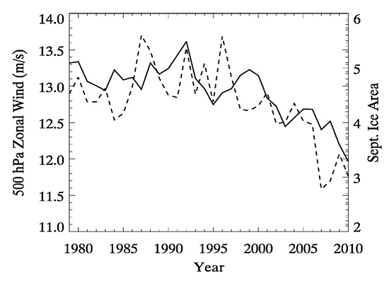
above: how the drop in high-altitude winds in autumn over the past 30 years (solid line) has closely tracked the decline in Arctic sea ice (dashed line). Graphic: Jennifer Francis, based on data from the National Center for Environmental Prediction, National Center for Atmospheric Research, and National Snow and Ice Data Center.
That's for autumn, and in recent years blocked patterns have often persisted into the winter, but what about the rest of the year? The tendency for the jet stream to slow down and meander more seems to have become a summer feature, too, well before the annual sea ice minimum. However, there is another important regional and seasonal variable: lying snow, both in the Arctic and sub-Arctic. This snow is melting progressively earlier over time: the sooner it melts, the sooner the soil beneath is warmed by the spring sunshine. There has been approximately 2C of late spring-early summer warming over high-latitude land areas since the mid-1980s, heat which is contributing to the Arctic Amplification effect during the summer months. Again, the probability is that Arctic Amplification can slow the jet stream and amplify its waves into slow-moving blocking patterns, bringing prolonged weather of one kind or another to various parts of the Northern Hemisphere.
In researching this post I had a useful discussion with Dr Jennifer Francis of the Institute of Marine and Coastal Sciences at Rutgers University, New Brunswick. Jennifer has published extensively on Arctic climate change and in recent years has been studying changes to the jet stream. I finished my Q&A session with a look at the future. What, I wanted to know, was the outlook? Would any pattern of change to the jet stream be linear in fashion? Jennifer replied:
"Hard to say if it's linear or otherwise - not enough years of data yet, and it's not clear if models are able to capture the behavior realistically. Some recent papers suggest they don't simulate blocking patterns well, for example, which are key for extreme weather. We have looked at a 4xCO2 run of the NCAR GCM, however, which suggests that (like the real atmosphere) the 500 hPa zonal winds will weaken substantially in all seasons (not just fall, which is the strongest signal in the real world), and also that the flow will become more meridional, that is, the ratio of north-south winds relative to the total flow will increase. I think the tendencies we're seeing in the real world will continue to increase. As we lose all the summer ice, the response in the fall may plateau somewhat (although Arctic Amplification will continue via the other factors), but as ice in the other seasons declines, we should see the response become stronger all year long."
That modelling jet stream behaviour is difficult should come as no suprise: we are entering Terra Incognita here, with Arctic sea ice melting far more rapidly than most previous predictions have suggested. It makes sense to suggest that - if sea ice melt is a prime driver here - that once all the variability in the system is 'used up' (i.e. when we see a seasonally sea ice free Arctic) then we should see a plateau effect in autumn/fall, but this is but one part of Arctic Amplification and the way the other variables such as poleward water vapour transport behave is just as important.
Conclusion
The Arctic has warmed about twice as much as the rest of the world and the responses to the warming by some variables such as sea ice have greatly exceeded expectations. Evidence is mounting to indicate that the response of the jet stream to this new thermal regime has been to tend to slow down and meander more, with a greater tendency to develop blocking patterns. In the UK, the run of wet, dull summers and the run of prolonged cold outbreaks in recent winters shows what can occur when the jet steam behaves in a meridional and sluggish fashion. At the moment it's more active: on the morning that this was written, April 14th, a 130-knot jetstreak was racing NE over the northwestern UK on the eastern limb of a deep upper trough: it was mild and wet with a sou-westerly gale blowing but with alternating bouts of sunny and cloudy, wet weather forecast for the week ahead. Changeable weather is the norm for NW Europe: prolonged periods of any weather type are historically atypical and may be noteworthy when they occur. Clearly, we need to get a good handle on what is going on here and how future responses may play out in our weather-patterns: already it seems to be the case that we are going to have to develop greater adaptability to a greater range of prolonged weather-extremes. How that plays out in terms of agriculture and economics remains to be seen, but there should be no room for complacency.
Acknowledgement and further reading:
My thanks to Dr Jennifer Francis for taking the time to respond to my numerous questions! For further reading into the recent research, the following paper is the one to start with both in terms of its content and its up-to-date references:
Francis, J. A. and S. J. Vavrus, 2012: Evidence Linking Arctic Amplification to Extreme Weather in Mid-Latitudes, Geophys. Res. Lett., Vol. 39, L06801, doi:10.1029/2012GL051000 PDF


 Arguments


I realise I'm in danger of "dogpiling", but would like to highlight this point.
Chuck Wiese @50:
"Arctic amplification therefore WEAKENS, not strengthens the latitudinal gradient of temperature."
(This is in agreement with the OP)
Phillipe @40
"When temperature contrasts are very strong, the meanders are shallow in amplitude and strong weather systems (depressions) rapidly cross the Atlantic bringing wet and windy conditions to Europe. This is described as a "high" zonal index, where the contrasts between the temperate and polar zones are strong with little mixing north or south"
So the weakening temperature gradient increases the meanders in the jet stream, no ?
There is another paper by Francis in 2015 doi:10.1098/rsta.2014.0170 which is quite interesting. It uses self organizing maps, for one thing, which i quite like as a technique, subject to the usual caveats. But it also clearly points out that "A slower jet stream tends to take a more meandering (meridional) path as it encircles the Northern Hemisphere [13,14]. Large north–south jet-stream waves in a highly meandering flow tend to travel eastward more slowly. These waves create the high- and low-pressure systems at the surface, so their slower eastward progression increases the likelihood of persistent weather patterns that can cause a variety of extreme events [15]." The references are quite illuminating, I entertain a (probably futile) hope that some of the denialati in this thread might read them.
[PS] Added link.
Sid and Phil: There is only one primary reason why atmospheric Rossby waves amplify and create large storms, severe weather and temperature extremes. It boils down to an excessively large storage of potential energy stored as the gradient of temperature across the latitude lines. The waves are then ampified by the increased incidence of baroclinity which starts the process of wave amplification through the process of cyclogenesis, which further amplifies the waves by the incipient advection of temperature which displces atmospheric mass. A storm is generated in the outflow process of this and a high pressure system is generated with a "ridge" downwind of the vertical motions and mass displacement.
These processes use the stored energy and transfer heat poleward to relax the gradient of temperature. As the created storms fill, atmospheric mass is redistributed towards its hydrostatic equilibrium and the flow degenerates back to zonal and high index, with a lessened latitudinal temperature gradient. "arctic amplification" if it were occuring would do the opposite of what Francis claims.
The only exception to the physics here is in the tropical regime where tropical storms and hurricanes develop and their energy source is the warmed waters of spring and summer that convert increased evaporation into latent heat.
Speaking of that, it is also true that the recent hurricane Patricia was not the strongest hurricane ever in the western hemisphere. It was beat by super typhoon Nancy that hit Japan in September of 1961. Aircraft recanaissance measured 215 MPH winds sustained at 1 minute before this typhoon made landafll. 172 Japanese were killed with 11,539 homes destroyed and 280,000 homes flooded from storm surge. This super typhoon held a lot of its strength together for a longer period than Patricia did, which weakened rapidly as it made landfall and caused little damage with a much smaller core of CAT 5 winds.
Chuck Wiese
Meteorologist
[PS] I am sure other commentators will respond to problems with this post, but I want to request again that you cite (and preferably quote) references in support of your argument. Without those cites, your post is close to sloganeering. You have been warned already. Persisting with this line will result in deleted posts. The authority accepted here is peer-reviewed research, not claims people sign their posts with.
Chuck,
Speaking about the recent hurricane you need to check your hemispheres. Japan is in the Eastern Hemisphere, not the Western. You look stupid when you make such basic errors. Jeff Masters recently discussed the Hurricane wind speeds from the 1960's. Your discription is false. The 1960's wind speeds were estimated by eye, not with a one minute measured average. It is well known that these old wind speeds are not reliable.
Why should I believe your personal interpretation of a 1957(??) textbook when you do not even know how wind speeds were measured? Even if your ancient textbook is different from current Rossby wave science, why should anyone think that it is correct instead of current peer reviewed papers? Atmospheric Physics has advanced somewhat in the past 60 years.
This is a scientific blog. You are required to either cite current literature or substantial evidence to support your claims. The unsupported word of someone who never put in the work to earn his PhD will not get you much. You will never convince anyone that you are correct when you admit you are unable to explain the science.
[PS] we are rapidly approaching dog-piling here. While I strongly agree that Chuck must provide citations rather than sloganeering, I would also ask that commentators only reply if they have a substantive response to points made. I would particularly ask that people refrain from responding to tone.
ChuckWiese @53 : Thank you for your further comments on Rossby Waves, but please clarify what you are saying about Francis & Vavrus ["arctic amplification . . . would do the opposite of what Francis claims"]
You have not made it quite clear whether you mean: (a) arctic amplification [as a subset of global warming] is occurring yet Francis's ideas are wrong, or (b) arctic warming is not occurring and so Francis's ideas are correct (to that extent).
Also perhaps worth mentioning what you yourself think are the atmospheric circulation consequences of the present-century's increasing areas of ice-free Polar Sea (during the overall winter/summer cycle). I presume, tentatively, that large asymmetric & irregular patches of warmer sea would have some noticeable effect on zonal & meridional air flow. But is that the case; and if so, to what extent?
I hope you will correct your earlier comments about Japan & nearby ocean being "in the western hemisphere" . . . though in the bigger picture of course it doesn't really matter how you care to divide the categories of hemispheres. It's all one world, after all. (Compare, for instance, the very well documented and devastatingly strong Typhoon Haiyan, of a couple of years back.)
Chuck Weise Meteorologist @50.
You kick off by conflating Francis & Vavrus (2012) with the post above which is not making your task any easier. Let us here ignore the post above.
The quote you then provide from Francis & Vavrus (2012) is, as you say, from the paper's conclusion:-
I would suggest that it is a little premature to immediately declare the whole paper in error because this quote is contrary to your own understanding of the theoretical situation. It would be prudent to at least examine the paper in its entirity. It may well be that an explanation is forthcoming. And indeed there is. A reference is provided within the body of the paper.
So it would be pudent of you to examine Palmén, E., and C. W. Newton (1969), Atmospheric Circulation Systems, Int. Geophys. Ser., vol. 13, Academic, New York. to see what is being discussed. Yet again this matter throws up an old reference book. It appears available on-line via Researchgate which is a step too far for me. So you could be on your own in this examination.
Your point @50 that the theoretical maximum amplitude of an atmospheric Rossby wave is proportional to the square root of poleward air speed does appear to suggest a contrary relationship than the one you quote from Francis & Vavrus (2012) and such an understanding would suggest the paper makes an egregious error. But do note that it is also true this paper has been challenged since publication yet not challenged on the specific point you raise. (At least, from a limited look I have not seen such a published challenge.) This is not what we would expect if the quote were as egregiously wrong as suggested @50.
Chuck,
You are not addressing the problem I raised, which is that all other sources I have looked so far concur with Francis on the temperature gradient, zonal index and amplitude relationship. I provided 2 of these sources, but I looked at more and they all agreed. So your problem is not only with Francis, it is also with the University of Oregon, NOAA and numerous other institutions of superior education offering meteorology courses. Innumerable other meteorologists agree with this, and, more importantly, observations of winds aloft and temperatures are also consistent with it.
A colleague of yours, meteorologist Paul Douglas, shows some nice imagery on his blog:
http://pauldouglasweather.blogspot.com/2015/02/winter-drags-extended-march-thaw-in.html
As for the paper mentioned earlier, I seriously doubt that a meteorology paper published in Nature Geoscience wold have been reviewed by people without expertise in the field, and I find it equally dubious that the rest of the authors of the paper would have no such expertise. Seriously, how likely could that be?
Of course, there is always the possibility that they're all involved in a vast conspiracy, along with NOAA, NASA and everyone else. I guess I will have to follow my judgement of the relative probabilities of being real for each option.
Unfortunately I'm not sure that I will have the time to further investigate the matter. I hope this gets sorted out. Does your formula say exponent one half? I've tried to locate online texts with relevant formulas. It's not the easiest to write mathematical formulas on SkS.
Michael Sweet, MA Rodger and Philippe: I will answer your comments in this one post.
To repeat, Jennifer Francis's conclusion in her paper and this article are wrong. You are trying to claim that just because she wrote it and it is more recent than the published and peer reviewed literature along with other recent publications, that time erases in and of itself older work. That is not how science works and any scientist with a doctorate degree knows this, and this is precisely what I have seen in many instances of work done in climate papers as they relate to atmospheric science. Assumptions are made and sometimes without bothering to look at the founding principles to see if they agree. I provided the references of this literature to show they do not and the specific equation that is used to estime a maximun Rossby wave amplitude. And as it solved from the primary equations, it is obvious that wind speed and latitude determine that amplitude with speed controlling. (And Philippe, yes, I meant EXP 1/2 to maen taking the square root of V/B.) In order for Francis and Vavrus to claim otherwise, they need to show where this realtionship is wrong, or where it was improperly derived. They have done neither. Ma Rodgers, your response is a bit more reasonable but none the less, there seems to be an attitude that older work is irrelevant if today's Phd's ignore it. That is preposterous. If Francis or Varus can show where these equations in the founding literature are wrong, then they have a valid hypothesis, but not until then and the reviewers should have caught the error in assumption.
Philippe, your post contains no citations that show how to compute the amplitute of Rossby waves or where the equation I gave is wrong. That is what is the key point in my writing to criticize, and as the moderator has asked of me, lets cut the dogpiling and "sloaganeering" . Your references not only fail to give a citation that disproves what I have provided, you are using references like the University of Oregon and calling them an "institution of superior education". What does this mean when they offer no major in atmospheric science or meteorology and have no Phd's on their staff to teach atmospheric science?
Turning briefly to the hurricanes I brought up, a few points for Michael Sweet: You are correct about hemispheres being divided at the dateline or 180 degree meridian so my bad for misstating that. But I was thinking of the body of water called the Pacific ocean that provides the fuel to both eastern Pacific hurricanes and western Pacific typhoons. Would that not be a better comparative for the puposes of climate rather than assigning an arbitrary cut-off meridian that has no climate significance?
To challenge some of your other points, I spoke by telephone this morning with Dr. Chris Landsea of the National Hurricane Center and asked about observing techniques that were used in the 1960's. To start with, he does agree the older techniques are not as good as those used today but I never said older methods were better. It is interesting to note that what they did do in those days was fly recanaissance aircraft down to 500 ft off the ocean surface under cloud bases to estimate the winds and had a US Air Force Weather Officer estimate visual conditions by a developed hurricane "beaufort scale". They also used doppler techniques as Jeff Masters mentions, but his quote from a "hurricane expert" at the time regarding the doppler technique makes no sense. The quote claims that because they were concerned about getting attenuation from flying sea spray that readings from the doppler shift would be erroneously high. The opposite would actually be true and the readings would be too low because the reference would be with respect to the true airspeed of the aircraft to get the ground speed and compute the surface winds. That is something I am quite faniliar with being an FAA licensed Airline Transport Pilot and Flight Engineer. The point in all of this is not to claim methods were better then than now, but there is no justification in claiming speeds were measured too high alone, either. There is a degree of error in any neasurement and these criticisms do not address the actual numerical significance. It would appear by these techniques they were accurate and the margin of error could be in either direction with changing circumstances.
BTW, Dr. Landsea has informed me that the National Hurricane Center is writing up Hurricane Patricia and intends on putting it into its perspective in comparing it to the record. Those of you who believe hurricane intensity is getting stronger and related to "climate change" may not like what he is going to say, but it will be up on their website soon.
Finally, I sense a lot of tension from the readers of this blog as well as a venomous dislike of any who take issue with the orthodoxy of what is written about humman induced climate change from CO2. There also seems to be a double standard on this site. The moderator is asking as do the bloggers to provide specific citations to back up claims made about a topic like this. There is nothing wrong with asking for them and I have provided them but I take note of the fact that the author of this article provides no citations for any of his claims other than a reference to Jennifer Francis at the end. Who is John Mason, what are his qualifications to write about meteorology or atmospheric science and why did the moderator accept the article without asking for specific citations of published work to back his assertions be included?
There is also a fake credential degradation used by warmers that needs to be pointed out here. Anyone who holds a bachelors degree or higher in atmospheric science is qualified for employment as a forecast or other operations meteorologist by the US National Weather Service. That is a national standard applied by the agency. It has nothing to do with "qualifying" to be a TV weathercaster. In that arena, there are no standards and plenty of scientific illiterates who know little but use the AMS TV Seal of Approval whose standards were lowerd to less than academic to claim the use of the title "meteorologist". Many of these people call themselves meteorologists but they absolutely do not meet the professional standards required for employment at the US Weather Service and that is the standard that counts. There are no licensing authorities that police the use of this title. The US Weather Service used to do it but ceased after standards were lowered to obtain a TV or Radio AMS seal. Hope this all helps.
Chuck Wiese
Meteorologist
[RH] Can we assume, based on your continued lack of citations, that there is no actual published research that supports your position. (Honest question.)
Moderator: I don't understand the concern in your question. The equation I provided was from published, peer reviewed and accepted literature into the atmospheric science published data base and the texbooks authors are all Phd's in atmospheric science. This material was taught in dynamic meteorology as part of my major and I don't believe any of the professors I had studied under would be so foolish as to present equations which are not valid or correct.
Textbooks for learning and lecture are not published scientific research papers as I believe you are refering to. And no, I have not seen any papers published that specifically used this equation. Does that make any difference? Every professor I know of has these texts in their own personal library and they are more commonly used as references and tools that simplify their own work and used to teach with as well. If you've never seen the equation before, does that make it wrong? The equation speaks for itself and it was derived by the authors I have given you correctly. If this paper by Vavrus and Francis is one of the first published in a climate journal that addresses Rossby wave theory, it shouldn't be a surprise that you haven't seen it elsewhere, should it?
Chuck Wiese
Meteorologist
[RH] You'll forgive my personal skepticism of your lengthy explanations when you've expressed a rejection of basic greenhouse theory, vehemently rejected the work of a well established climate researcher, and failed to present any supporting research. You state here in this comment that the equation is from published research but have been unable to cite that research. If you're serious about engaging here I believe that would be a positive move toward advancing the discussion. Short of that you're merely sloganeering (which, as a moderator, is one of my primary concerns).
If I do the calculation for max amplitude of Rossby wave 2*sqrt(V/(2*omega*cos(phi)/a)) i get, as expected a few thousand miles. Why is this relevant ? Francis argues a different point entirely, that the jet stream has slowed and that meanders are more frequent, not that they exceed some hypothetical limit in a simplified atmosphere thats neglects topo and buncha other things. I advise those interested in these matters to read Isaac Held's most excellent blog
sidd
sidd: No, Francis is arguing that a slowed jet stream as she implies is happening means the amplitude of Rossby waves increases and thus causes more extremes in severe weather.
The point in the equation is to think of it in terms of its limits. A specific speed and latitude prove nothing. The point is that as the wind speed of the jet increases at a particular latitude, so must the amplittude of the wave. As speed decreases, so must the amplitude. This is the opposite of what Framcis and Vavrus are claiming and it is wrong.
Chuck Wiese
Meteorologist
[RH] "Francis is arguing that a slowed jet stream as she implies is happening means the amplitude of Rossby waves increases and thus causes more extremes in severe weather."
Please cite the passage where this is claimed. Again, we expect citations here.
Chuck @61, sidd @60
That the jet stream would meander more is indeed one of Francis's points (point 2 in this article)
Incidentally, whilst looking into this topic, I discovered that Jennifer Francis did her PhD here - a department founded by Phil Church who worked with Carl Rossby
Here is Francis's point 2 that Phil pointed to:
That is not at all the mechanism that Chuck wrote Francis claimed: "Francis is arguing that a slowed jet stream as she implies is happening means the amplitude of Rossby waves increases.'
Francis's point 1 described the consequence of slowing without mentioning it increasing wave amplitude. Instead,
Although I have not read in detail Chuck's comments nor the responses to his, I believe neither of these two of Francis's mechanisms is what Chuck claimed. Nor do I see any necessary contradiction between these two mechanisms: If Chuck is correct (I have no idea) insofar as slowing causes lower amplitude, that's fine as long as the slowing Francis described (from both her mechanisms) results in less amplitude reduction than the amplitude increase from her mechanism 2.
Ta da.
Moderator: Here is the abstract of Jennifer Francis's paper:
"New metrics and evidence are presented that support a linkage between rapid Arctic warming, relativeto Northern hemisphere mid-latitudes, and more frequent high-amplitude (wavy) jet-stream configurationsthat favor persistent weather patterns.Wefind robust relationships among seasonal andregional patterns of weaker poleward thickness gradients, weaker zonal upper-level winds, and a more meridional flow direction. These results suggest that as the Arctic continues to warm faster than elsewhere in response to rising greenhouse-gas concentrations, the frequency of extreme weather events caused by persistent jet-stream patterns will increase."
That passage was taken from here on the front page of her paper:
http://iopscience.iop.org/article/10.1088/1748-9326/10/1/014005/pdf
Chuck Wiese
Meteorologist
Tom: A couple of things. First, Francis does not supply any physical connection to her claim that as the arctic warms Rossby amplitude must increase. The physics of the equations supporting the Rossby wave behavior state otherwise and clearly define the amplitude of the waves being a function of latitude and speed of the flow, with the amplitude increasing or decreasing in proportion of the same direction as the speed. In other words, the opposite of what she claims.
Second, slower progression of the waves does indeed mean that weather patterns will be more persistent in the areas they coincide over. That can include severe weather and temperature extremes. But..the speed of Rossby waves is not the same as the amplitude and depends on the westerly component of wind, latitude and wavelength. It is quite apparent that as the westerlies decrease from increased meridional flow, the speed of the waves slow. But again, long waves, meaning high amplitude are dependent on inceasing, not decreasing north or south flow (meridional).
You take a passage from her paper that describes how arctic warming supposedly "stretches" the waves thus amplifying them. Then she claims with a warmer arctic, frigid arctic air can penetrate further south, the process causing temperature extremes. The obvious weakness I see in this statement without supporting evidence from her would be to ask the question that how is it that cold air from the arctic can penetrate further south in her scenario if the arctic is warming rapidly? And especially if she claims this can cause temperature extremes. This makes absolutely no sense.
Chuck Wiese
Meteorologist
[RH] This seems to be exactly the problem. Francis' statement makes perfect sense about arctic air penetrating south (being as arctic air will still be cooler than air to the south). I, and obviously others here, are dumbfounded that you so emphatically state things are wrong and don't make sense when, in truth, they're perfectly sensible. Same as with your rejection that CO2 is the main control knob for global mean temperature. Your issues over Rossby waves are more convoluted and hard to follow but I suspect it's a similar pattern.
Now i'm really done with that topic.
Nyhoo, the 2015 paper is more interesting, coz it has 360 degree coverage rather than the 0 to 140 of the 2012 paper, and uses a neat technique. Would love if our hosts might find time for analysis on that one especially the self organizing map bits.
sidd
@ 68,
I have already asked if you believe CO2 comes out of solution at higher temperatures. You refuse to answer as you know this is the key...
My mistake- you did answer that.
My latest question for you was: " You are saying CO2 has no effect on anything, perhaps?"
Sidd said pretty much everything there is to say. Chuck Wiese seems to have a Gerlisch and Tschneuer type of argument.
Ignore the U of O link if you must Mr Wiese, I provided other links, including one to your colleague Paul Douglas, who refers to NOAA and explains exactly the same thing outlined above, i.e. low zonal flows, high amplitudes.
The Francis and Vavrus paper is anything but isolated
http://www.pnas.org/content/111/34/12331.abstract
http://www.nature.com/ngeo/journal/v7/n9/abs/ngeo2234.html
Chuck Wiese seems sensitive to expertise and authority. This last paper includes many authors, I don't know exactly how many have PhDs but at least Francis, Coumou and Overland do. Coumou has extensive expertise in fluid dynamics. How likely is it that they all have missed something that Chuck Wiese is the only one to understand? And the reviewers as well? Really?
Besides, I maintain that the argument "it hasn't warmed in 18 years" is exclusively dependent on cherry picking data set and starting point and is misleading and dishonest.
Chuck Wiese @67
Very cold air in the arctic can warm rapidly and still be colder than (for example) slower-warming Texan air. How come Chuck Wiese Meteorologist doesn't realise this ?
For those who are intrerested, when Chuck Weise Meteorologist deigns to stray onto the topic of this comment thread, the equation he is constantly waving so vigourously ( Lx = 2π(u0/β)½ ) is derived here. You will note the equation applies to stationary waves which may be allowable as the Francis & Vavrus (2012) paper is mindful of blocking weather patterns. Also the quantity Lx is actually the wave length rather than the amplitude, although in the simple theoretical model being used amplitude will be proportional to wave length.
[RH] Being this is core to the OP I would request all commenters to direct their questions and observations to this issue.
MA Rodger @73, Wiese's formula is A = 2 *(ν/β)0.5, where A is amplitude, ν is the North/South component of the wind field, and β is the Rossby Parameter. In addition to calculating wavelength (Lx) rather than amplitude, the formula you have found includes pi as a factor and uses the uo, ie, the "basic flow" of the geostrophic velocity, ie, the flow excluding perturbations. Under the conditions of the derivation, that is said to be a North/South flow but it is not equivalent to ν in all circumstances and that may be a relevant difference between the two formulas. So, while the formulas are superficially similar, they are not the same.
Tom: Thanks for correcting MA Rodgers. He is incorrect to claim the equation he found was what I used. His reference is similar to the derivation of the equation of wave speed for an autobarotropic wave, given as
c= U - BL^2/4pi^2.
If c is wave speed, U zonal wind speed, L wave length and B the Rossby parameter, this realtion is then solved for L by setting c equal to zero. The result is what he just wrote, but that is not the maximum amplitude.
Chuck Wiese
Meteorologist
Phil and moderator: If you are starting with a warmer source region of arctic as is implied in the Francis paper, ( artcic amplification) the temperature of the airmass must be warmer. This means if it is driven southward to a place like Texas as in your examples, it will arrive warmer than it would if the source region in the arctic was colder to start. Since the argument Francis makes claims you will get persistent "stretched" long waves as a result of this warming, she then claims this will lead to temperature extremes.
It is implicit from this that the meaning would be equaling or exceeding current climatological extremes. It is pointless to use that phraseology if the expectation is that future cold will not be as cold as today because of the warming. If what she claims is true, we are moving away from extremes, not engaging or exceeding them. But this claim of hers cannot be so if wave amplitude depends upon speed, which the equations make clear. The wave amplitudes must decrease and the troughs of the waves must migrate to higher latitude. This is basic atmospheric science.
Chuck Wiese
Meteorologist
[RH] If this is "basic atmospheric physics" you should be able to present published research that says exactly this. If there's not any published research that states exactly what you're claiming, contradicting Dr. Francis, then there are two possibilities. (a) No one has shown this in the research, and there's an opportunity to publish an important paper, or (b) no one else working in the field agrees with your conclusions.
We know from clear, empirical measurements that the arctic is warming faster. So, by your claims, that would result in fewer extreme weather events.
Chuck Weise Meteorologist @75.
Thank you so much for confirming that the equation I presented @73 is not the equation you are talking about. Given the adverse circumstance here, I do struggle to get to grips with this equation and its derivation. In that regard, can you confirm that the your equation is of the form presented @74. And also concerning it's derivation, the references you quoted @35 as your sources of this equation are:-
While you appear reluctant to venture an explanation for the derivation of this equation, likely because "this topic is long, complex and math intensive" in your eyes, such reference books as these do tend to number all the equations they present. So it would be simplicity itself to provide the equation number of this formula within these two chapters. This would be most helpful.
Re: @76
The jet stream, as I understand it, acts a barrier that inhibits air currents from crossing it. If the meanders in it increase, then air currents can progress further south (or north) before encountering it. This allows cold air from the arctic to progress further south in the places where the jetstream meanders to the south, and warm air from temperate regions to progress further north where the jetstream meanders to the north. Furthermore since the jetstream acts a barrier to these air masses mixing, the cold air will remain cold since it will not come into contact with warm air.
I do, however take your point that arctic amplification will make arctic temperatures warmer than they were in the past. The trend the atmospheric temperatures over the last 15 years is about +0.12 degC/dec. Let us (for the sake of argument) assume that arctic temperatures are double that rate. However comparing temperatures:
Average March temperature in Nuuk between -7 and -11 C
Average March temperature in Austin Texas between +22 and +10C
would suggest that the fact that the arctic air would be slightly (0.24C) warmer than it would otherwise have been, is dwarfed by the fact that the larger meanders of the jet stream allow the cold (albeit slightly less cold) air penetrate further south.
Oops, I should have said arctic air would 0.24C warmer within a decade.
It would (simplistically) be 2.4C warmer within a century; I imagine, however, that arctic amplification is closely associated with the loss of ice albedo, and that given that observation and IPCC projection indicate a summer ice free arctic by mid 21st century, the amplification will slow.
BTW, in all of the above "warmer" refers "warmer than today". If you assume that the temperate region (Texas, in my example) warms at the global average then you need to half the difference.
Moderator: In response to your most recent post, whether there is a desire by me to publish such a paper is irrelevant. What is relevant is that I have personally written to both of these authors and asked them to explain their claims and demonstrate where I could be wrong. Vavrus never responded and Francis offered no other explanation of why my assertion is incorrect, but only and without any explanation insisted she is correct.
This is not how anyone should be approaching problems in science. Regardless if a paper is reviewed and accepted for publication as this one was, the reviewers may very well not have been versed in atmospheric scienvce as they should be. In addition, the authors have a responsibility to defend their own work and answer questions if they are approached directly as I have approached them. Their failure to do this is surely an indication the isues I raised are valid. That is a reasonable assertion until they can state they addressed my concerns in the review process, they are wrong and give a reference or explanation.
If anyone who had anything to do with this work diasagrees with my assertions, they owe it to the public to explain them and defend. To claim they disagree without an explanation is not acceptable. Ms. Francis is employed by Rutgers University and Vavrus by the Unviersity of Wisconsin and both receive funding from taxpayers.
Chuck Wiese
Meteorologist
[JH] You are now skating on the thin ice of excessive repetition which is prohibited by the SkS Comments Policy.
Please note that posting comments here at SkS is a privilege, not a right. This privilege can be rescinded if the posting individual treats adherence to the Comments Policy as optional, rather than the mandatory condition of participating in this online forum.
Please take the time to review the policy and ensure future comments are in full compliance with it. Thanks for your understanding and compliance in this matter.
[RH] The way people approach the problems of science is through publishing research. You've thus far been unable to provide supporting research for your claims, and contrary to how people actually approach the problems of science, you've only made claims that you understand this stuff while no one else does. It's quite obvious that you are the one who does not adhere to a scientific approach.
In terms of what is "owed to the public," the only thing that is owed has already been delivered. Dr. Francis has published her work in the peer reviewed literature, as scientists are expected to do. If you have a challenge to the conclusions of her research it is your responsibility to submit those to peer review. Apparently this is something you're unwilling or incapable of doing.
Chuck Wiese @80 sets up a hypocritical standard such that:
But he insists it is not incumbent on him to defend and explain his assertions. Indeed, as he claims his views are based on standard (but out of print, and unavailable second hand) textbooks, it should be very easy for him to defend and explain his views by showing the derivation of the relevant formula, or failing that, quoting the textbooks for their derivation.
Indeed, not even that is being asked of him. We would be content if he simply listed the scientific papers in which the result was first derived (that being far more likely to be accessible than out of print, and unavailable second hand text books). Most recently MA Rodger @77 has reduced the request on his behalf to a mere listing of the formula numbers in the text books that purportedly contain the formula. Even that request is, apparently, to much a demand on Chuck Wiese in defense of his views.
Yet he thinks it is incumbent on atmospheric scientists to devote time to defending their views against any internet crank that has the wit to send them an email.
That is not how science works. Any such communication from a scientist is, and must always be only a courtesy. If it is not, you place a blank check on scientists time such that internet pseudo-scientists can at will permanently prevent them pursuing further research, or even their mandated teaching requirements (if university based). Rather, the way science works is that, if you think there is a problem with a paper, you pursue it through (ideally) peer reviewed responses - the step Chuck Wiese refuses to make.
Chuck Wiese @82, John Mason in fact provides a reference for his claims in the discussion he had with Jennifer Francis, and in the paper you are referred to for further reading (Francis and Vargus, 2012). That is, as the Sun has cooled (very slightly) the Earth has warmed. That might be enough for some, but if any key point of the article were challenged, we would expect Mason to provide appropriate data, explicate the reasoning behind the claim and/or provide a suitable reference if no other commentor was able to do so before hand. That is, we would expect the same standard we apply to you, and that you apply to Jennifer Francis, but fail of in your own behaviour.
In fact, you have challenged a key point, but the reference for that point is already given in the article (ie, Francis and Vargus (2012)) and the relevant section has been quoted by commentors above. You yourself have identified Francis as making the claim, so it is not in dispute that Mason has a suitable reference for his claims. Nor would it be in dispute that you had a suitable reference for yours if you would only quote the relevant passages from the difficult to obtain references you use, something you steadfastly refuse to do.
With regard to the deleted posts, I believe they were deleted due to being off topic, contrary to both the comments policy and the direction from the moderator @73 above, a direction you have chosen to ignore. It is unfortunate that your rejection of the moderators claim @59 above that you "...expressed a rejection of basic greenhouse theory" has been deleted, but that claim was made before the indication of a strict application of the rule requiring that you remain on topic. It is still open to you to rebut the moderator's claims at one of the SkS posts that discuss basic greenhouse physics. No comment of yours was deleted for being off topic prior to that notice. Furrther, the moderator making the claim @59 has not deleted any of your posts, and some miscommunication may have been involved.
By all means, however, become yet another denier who interprets their inability to comply with the simple requirements for posting at SkS as censorship of their views. As the views expressed are not a grounds for moderation - that claim is and has always been false. The failure to comply, however, seems to indicate that deniers are unable to express their views in a clear, evidence based manner while remaining on topic (ie, not wondering of into some form or another of a Gish Gallop). That does not speak well for the coherence, or emperical basis of those denier views.
[JH] Wiese's most recent post was a moderation complaint and was deleted. He had been advised to review the SkS Comments Policy but apparently chose not to do so.
Chuck Wiese - Francis and Vavrus are under exactly zero responsibility to indulge the complaints of someone who hasn't done the work, who isn't willing to write a Comment or a dissenting peer-reviewed article.
You have been disagreeing with recent research with (unclear) references to textbooks from the 1950's - has it not occurred to you that our knowledge of various phenomena may have improved in the interim? Or that recent papers are discussing recent developments, developments that may not have been covered back when you received your training? I might as well argue that plate tectonics is absurd, based on a textbook from the 1920's.
If you indeed think that Francis and Vavrus (not to mention the many authors of recent papers discussing these works without rejecting them) are completely and in an elementary fashion wrong, do the work. Otherwise, regardless of the accuracy of your assertions, you will be considered a crank whose views lack support.
On a related note - the opening post was written with direct reference to peer-reviewed literature, which is all the support required; it's supported by that work. Your repeated claims that you, because of your background and training, know better consist of an Argument from Authority - and without actual data, theory, references, or work pointing out where those papers have erred, that's a logical fallacy.
As the article says, the claim that the jet stream is stronger when the temperature gradient between North Pole and Ecuator is greater, is supported by the observational fact that it is typically stronger in winter than in summer. My question is: how much stronger?
In winter, the temperature gradient is of more than 50ºC (North Pole typically less than -30ºC, Ecuator over +20ºC). In summer, the temperature gradient is less than 30ºC (North Pole slightly over 0ºC, Ecuator still the same). The temperature gradient between Ecuator and Nort Pole has reduced to about HALF of what it was in winter, and in absolute terms, it has reduced by aproximately 25K. Does the jet stream change A LOT in response to this, or does it only change a little bit?
My main problem with this theory of our dangerous influence on the jet stream, is that it is true that we are reducing the gradient between North Pole and Ecuator, but we are talking about a reduction of what, half a degree? One degree? (it depends on which dataset you go to check) of this gradient, for the last 20 years. If this had the possibility of affecting the Jet Stream big time in any sense, then we should see HUGE differences in jet stream behaviour between winter and summer, every year. Is the difference in its behaviour, indeed, huge? We are talking of a seasonal variation of the temperature gradient that is roughly between 1 and 2 orders of magnitude bigger than the anthropogenic effect. In the months when the arctic is warming up, this gradient is reducing at a rate of one full centigrate degree every week!
So to get an idea of what we can expect, I would like to see a typical picture of the jet stream in winter, together with a typical picture of the jet stream in summer, to see the differences, divide the difference in its behaviour by 20 or 30, and then understand what kind of variation we are introducing with the anthropogenic warming of the arctic, quantitatively. Can anybody provide such pictures of the jet stream in summer/winter?
Nylo @84, polar amplification means there is already a large AGW based reduction in the equator to pole gradient. Relative to a 1951-1980 baseline, the winter temperaure differential has already reduced by 1.8 C. That is, we have already seen a reduction in the temperature gradient approximatly 10% of the seasonal difference. Based on RCP 8.5, by the end of the century that could rise to 25% of the seasonal difference. And yes, the seasonal difference is very significant, as is shown by the far greater variability in NH temperate zone winter temperatures than summer temperatures.
Tom Curtis @85, if, like you say, the NH temperate zone winter temperatures show "by far greater variability" than summer temperatures, and this is a time when the equator to pole gradient is at its maximum, doesn't that suggest the opposite of what the article claims? Wouldn't a reduction of the gradient (making it closer to the summer one) bring a more stable climate in the NH temperate zone, like we have in summer?
The article postulates that lower gradient means more chaotic climate. For this to have any chance of being close to the truth, we would have to see way more chaotic climate in summer than in winter, given the big reduction in the gradient of temperature arctic-tropics between winter and summer. You seem to be saying that the opposite is true, i.e. that the chaotic weather happens more in winter.
Nylo @86, you are correct, and obviously I did not think that through enough in my response.
As it happens, the greater temperature variability in the NH winter is not caused by the change in temperature gradient. Rather, it is caused by a large change in the position of the polar jet stream between summer and winter:
The more southerly polar jet stream in winter means the variability associated with its change of position moves further south and effects more territory. The contrast can be very stark in that air north of the polar front comes from the Arctic, while south of the polar front it comes from tropical and sub-tropical regions. What is more, as tropical temperatures show little seasonal variation, that means air from the south drawn north in the summer also shows little variation. In contrast, due to the low greenhouse effect at the poles, along with the fact that air temperature varies rapidly over the poles, there is a much larger seasonal contrast.
Tom Curtis @87, this large change in position of the polar jet stream between Summer and Winter... what do yo think that causes it, if not precisely the difference in temperature gradient Pole-Equator? What other thing can influence the position of the Jet Stream?
Nylo @ 84 - are you familiar with https://earth.nullschool.net
"earth - a visualization of global weather conditions forecast by supercomputers updated every three hours"
Among other great features - views of the jet stream in real time, history and forecase
I have followed this discussion with some interest.
My thanks to the author for the fine overview. After I re-read it a few more times I may start to understand it. At present I understand each chunk separately, but trying to see it all together still escapes me. Keep it up.
My thanks also to the moderator for valiant efforts to minimimize the throwing of brickbats, and keep discussion on a civil plane.
The flash (.swf) movies in this article do not work (for me). My browser refuses to load them as this website uses the HTTPS protocol and the .swf files are to be loaded over the HTTP protocol; their URL starts with "http://". For safety the browser refuses to embed not-secured obects in a secured page. I hope this helps.
[DB] Try it now.
I have a hard time understanding what the tropopause is reading this article. It this not just the real story behind the existence of this phenomena?
https://en.wikipedia.org/wiki/Maximum_parcel_level
In other words: Isn't it just the bounady above which a parcel of air can only get above when it is (almost) completely dry? So any parcel of air that contains water vapour in any concentration will never have enough
buoyancy to get above that 'magic' boundary, right?
@91
I see a link to a SWF file is now like:
https://www.brightstarstemeculavalley.org/science/zonalFlow.swf
So the difference in safe (HTTPS) and unsafe (HTTPS) protocols is no longer the problem. But the site brightstarstemeculavalley.org does not work with https. See:
https://www.brightstarstemeculavalley.org/
Thereby the flash movies still do not work, sorry.
Here:
https://en.wikipedia.org/wiki/Synoptic_scale_meteorology
I read:
"Low-pressure areas and their related frontal zones occur on the leading edge of a trough within the Rossby wave pattern, while high-pressure areas form on the back edge of the trough."
I did not read that in this article, or did I miss it?