Climate Science Glossary

Term Lookup

Enter a term in the search box to find its definition.

Settings

Use the controls in the far right panel to increase or decrease the number of terms automatically displayed (or to completely turn that feature off).

Term Lookup

Settings


All IPCC definitions taken from Climate Change 2007: The Physical Science Basis. Working Group I Contribution to the Fourth Assessment Report of the Intergovernmental Panel on Climate Change, Annex I, Glossary, pp. 941-954. Cambridge University Press.

Home Arguments Software Resources Comments The Consensus Project Translations About Support

Bluesky Facebook LinkedIn Mastodon MeWe

Twitter YouTube RSS Posts RSS Comments Email Subscribe


Climate's changed before
It's the sun
It's not bad
There is no consensus
It's cooling
Models are unreliable
Temp record is unreliable
Animals and plants can adapt
It hasn't warmed since 1998
Antarctica is gaining ice
View All Arguments...


Username
Password
New? Register here
Forgot your password?

Latest Posts

Archives

Trigger for past rapid sea level rise discovered

Posted on 23 July 2012 by John Hartz

This is a reprint of a news release posted by the University of Bristol (UK) on July 11, 2012.

green line

The cause of rapid sea level rise in the past has been found by scientists at the University of Bristol using climate and ice sheet models. The process, named ‘saddle-collapse’, was found to be the cause of two rapid sea level rise events: the Meltwater pulse 1a (MWP1a) around 14,600 years ago and the ‘8,200 year’ event. The research was published in the July 12 issue of Nature.
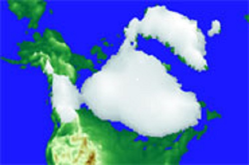
Pictoral simulation of North American ice sheet

North American ice sheet during the saddle collapse, 14,600 years ago, simulated in this study. Image by Dr Lauren Gregoire.

Using a climate model, Dr Lauren Gregoire of Bristol’s School of Geographical Sciences and colleagues unearthed the series of events that led to saddle-collapse in which domes of ice over North America became separated, leading to rapid melting and the opening of an ice free corridor. Evidence of these events has been recorded in ocean cores and fossil coral reefs; however, to date the reason behind the events was unclear and widely debated.

Ice domes up to 3 km thick (three times the height of Snowdon), formed in regions of high snowfall and higher topography, such as the Rocky Mountains. Together with the saddles – lower valleys of ice between the domes – these made up the ice sheet.

Towards the end of the last ice age, at the time of mammoths and primitive humans, the climate naturally warmed. This started to melt ice at increasingly high elevations, eventually reaching and melting the saddle area between the ice domes. This triggered a vicious circle in which the melting saddle would lower, reach warmer altitudes and melt even more rapidly until the saddle had completely melted. In just 500 years, the saddles disappeared and only the ice domes remained.

The melted ice flowed into the oceans leading to rapid sea level rises of 9 m in 500 years during the Meltwater pulse 1a event 14,600 years ago and 2.5 m in the second event, 8,200 years ago.

Dr Gregoire, lead author of the study, said: “We didn’t expect our model to produce such a rapid sea level rise. We got really excited when we realised that the events we simulated corresponded to real events!”

In the model, Dr Gregoire found that saddle-collapse could explain a significant amount of the sea level rise observed: “The meltwater pulse produced by the saddle-collapse can explain more than half of the sea level jump observed around 14,600 years ago. The rest probably came from the progressive melting of ice sheets in Europe and Antarctica.”

This research not only identifies the process which caused the melting of the North American ice sheet and the trigger for rapid sea level rises in the past, but also increases our understanding of the nature of ice sheets and climate change, allowing further questions to be posed and, with more research, answered.

Research like this allows climate and ice sheet models to be tested against evidence from the real world. If climate models are able to reflect patterns observed in natural records our confidence in them increases. This is particularly relevant where the models are also used to investigate the effect of climate change on ice sheets in the future.

The study was funded by the NICE Marie Curie Research Training Network and the Natural Environment Research Council (NERC), and the numerical model simulations were carried out using the facilities of the Advanced Computing Research Centre (ACRC) at the University of Bristol.

Subject paper

Deglacial rapid sea level rises caused by ice-sheet saddle collapses, Lauren J. Gregoire, Antony J. Payne & Paul J. Valdes, Nature, Volume: 487, Pages: 219–222, Date published: (12 July 2012) DOI:10.1038/nature11257

Received 23 February 2012, Accepted 21 May 2012, Published online 11 July 2012

0 0

Printable Version  |  Link to this page

Comments

Comments 1 to 34:

  1. Possible Sea Level Rise of 1-3 meters (or more) within the next 50 years Based on the current rate humans put Co2 into the atmosphere, which is 10,000 times faster than the natural processes. For that matter and potential singular positive feedbacks the rate of Sea Level Rise (SLR) can be assumed to rise with a similar rate. And for that matter there is no equivalent in the earth recorded history. The main SLR rise is likely not to come from melted water, rather then thermal expansion, which is attributed to be 70-75% of current observed SLR.
    0 0
    Moderator Response: [DB] Fixed link.
  2. Anyone monitoring the height of the Greenland dome?
    0 0
  3. Chris Machens, I am considered one of the more "alarmist" among the SkS ranks, yet your claim on your blog of 100 meter SLR over the next 100-200 years is quite frankly incredulous. For one thing, not enough ice exists to cover that gap due to melt nor do 1-2 centuries give enough time for full thermal equilibria of the ocean depths to be reached to get the full thermal expansion effects. I'm happy to entertain many possibilities, no matter how wild, but in the end it comes down to physics and evidence. As the esteemed Martin Vermeer suggests on your blog, perhaps you should check your maths. As it stands, your comment is not very on-topic for the OP of this thread.
    0 0
  4. I think this article would be improved by including caveats. The scientific conclusions may be strong, but not definite. Uncomfortable with absolute language here.
    0 0
  5. Barry, note that this SkS blog post is a reprint.
    0 0
  6. Chris Machens, The maximum SL in the top warmth of Eocene (~40Ma) was 70m above present. I find your claim that it could rise 30m further above that is less likely than runaway greenhouse effect, during which the water would boil at the surface while the bottom part would remain cold. So the total volume of ocean would not have a chance of thermal expansion to reach your figure before it starts to evaporate.
    0 0
  7. This article incorrectly puts a figure of SLR 9 m in 500a during MWP1A, whereas the quote from www.nature.com reads "14–18 metres over 350 years" which is substantially different figure. This article does not explain Heinrich events (5 of them between 45ka - 15ka) each attributed to the melt pulse of 5m/100a. Other than that, the results are good news: Greenland dome does not have "saddle shape", so future warming can spare us the MWP1A and 8.2K-like events.
    0 0
  8. To quote from my post: The paleoclimate record also shows that 560 ppm would be enough to melt all the ice in the Arctic, and later the Antarctic. Rohling said that once the Antarctic melts, sea levels would rise by 60 to 70 meters. “If governments keep going the way they are going,” Hansen added, “the planet will reach an ice-free state.” Now it would be interesting to know exactly what the maximum possible thermal expansion could be on top of the melted water.
    0 0
  9. Also the liquid is not distributed equally. Which suggest that some part will be considerable above that figure and other less so. The point with the image of sea level rise is to show us the future. Because with current emissions, we will get there.
    0 0
  10. Again, Chris, even a 70-meter SLR implies the entirety of the GIS, WAIS and the EAIS will have to melt/make its way to the sea in some fashion by 2100-2200 for your graphic in your blog post to have any semblance of accuracy. Show me some comp in the paleo record whereby 70 meters SLR was achieved in a world already at an interglacial peak and then you will have my attention. As an FYI, I touched on SLR impacts around the world in this SkS post: http://www.skepticalscience.com/mapping_sea_level_rise.html
    0 0
  11. Again. The point is to show what the impact of an ice free state looks like. Also i suggest you re-read the post since it got updated. For a further discussion on the topic i invite you and others to comment on that post, since it is off topic here.
    0 0
  12. And again, addition of water/ice sufficient to raise global sea levels by even 70 meters would have the effect of dampening much of the thermal expansion you anticipate as most of the mass added will be near the freezing point of water. That level of ice mass added to the world's oceans would occupy nearly 100% of the world's SLR over that period. And if you were to ask Eelco Rohling if your timetable of SLR had any merit he'd also be incredulous. And (how I hate this repetitiousness) I have indeed re-read your post. All previous criticisms still stand. Despite that fact that I am still the SkS author most likely to be in your circle, you are not convincing.
    0 0
  13. I think that you and others missing a lot of the future environmental setup. This begins with less ocean upwelling - hence less cooling of the upper surface layer. Rohling and Hansen say 70 meters SLR from melt water alone and i have yet to see any hard data about thermal expansion. Current SLR is attributed for the most part to 70-75% thermal expansion i see no reason why this should change considerable. And with modest "natural" climate changes as discussed in this article here, we have already a realm of SLR within a few centuries. It makes a lot of sense to assume that anthropogenic driven SLR will advance much faster, as we know it does, from our observations. Maybe it is not 100 meters but even 20 meters will be catastrophic. I really have no intention to argue about a few meters and that is why i wrote below that image that it is not accurate. The point is that things will be faster than in the past of earth history and any modelling is helpful in our learning and understanding of this threat. So if we know that within 350 years a SLR of 18 meters can happen, than we can assume that the magnitude with faster Co2 addition to the system, will have an effect on the timescale. We are today 10.000 faster than the natural process. And we have data from coral reef proxies which show rapid SLR within a few decades.
    0 0
  14. Chris, on what basis do you: 1. Maintain there will be less ocean upwelling? Do you think the upper surface layer exists in a vacuum, disjointed from the layers below? We know that the deeper layers are warming, thus we know both upwelling and downwelling still exists between the ocean layers. Please furnish a credible mechanism under which this might occur. 2. Assert that current SLR attribution to thermal expansion will not change? Indeed, current understanding is that it is indeed changing, with the component due to melt already increasing. With many meters of ice-melt/mass loss already in the pipeline (century+ timescale). 3. The 100-meter assertion was yours, thus it is yours to defend. If you screwed up your maths, then admit it. What we (you and I, not the rest of SkS) have in common: 1. The GIS and the WAIS are screwed. Indeed, in a future sense their melt has already happened (when one views time a certain way), based on today's CO2 levels and the forcings/feedbacks derived from it. 2. Yes, 20 meters SLR is catastrophic, and may/will happen (given time). The point you miss is that 2 meters SLR is catastrophic, and will likely happen to the world's seaport cities ere the centuries end. All SLR which happens after that, and which will continue for centuries, is moot. 3. Yes, we are changing things many times faster than any comp in the paleo record. And also faster than mankind as a species can wake up to and internalize. And thus, mitigation is likely already out as a viable option. Which leaves suffering and adaptation. The former on a global scale; the latter, on a much smaller scale (for those that still live).
    0 0
  15. Thanks, Daniel. Still, the article doesn't reflect the uncertainty in the abstract. The link seems to be busted - maybe a wrong backslash in there? Here 'tis if anyone else is having my problem. http://www.bristol.ac.uk/news/2012/8626.html
    0 0
    Moderator Response: [JH] The embedded link in the introduction to the OP has been fixed. Thank you for bringing this to our attention.
  16. Chris Machens @13,
    ...i have yet to see any hard data about thermal expansion. Current SLR is attributed for the most part to 70-75% thermal expansion i see no reason why this should change considerable
    You can calculate termal expansion from this data and the average ocean depth of 4000m. The PETM studies calculated the temp rise of deep ocean as 8K from O18 ratio. The corresponding thermal SLR was 5m, which is about 1.1% vol. Your number of 30m indicates thermal volume expansion of close to 1%, which is equiv to 45K temp rise in the link I provided above. Not strictly the boiling point yet so physically possible but pointless to even consider as whole life (except some bacteria) would be dead long beforehand. So before claiming "I see no reason why this [thermal expansion component of SLR] should change considerable", check you basic maths.
    0 0
  17. Chriskoz, the USGS 2003 numbers assume a maximum SLR (without thermal expansion) of 80 meters. http://pubs.usgs.gov/fs/fs2-00/ And as i said above, i have no interest in discussing if there will be 80, 90 or 100 meters SLR equivalent. he impact from massive SLR will be felt globally differently, depending on the planets gravitational field and mass movements. Therefore will an ice free state have SLR of above 100 meters.
    0 0
  18. chriskoz #16:
    The PETM studies calculated the temp rise of deep ocean as 8K from O18 ratio. The corresponding thermal SLR was 5m, which is about 1.1% vol.
    Surely you mean 0.11%?
    0 0
  19. This is the thread to link to when Tony Watts again claims that the "alarmist" side doesn't call out their own...
    0 0
  20. Danial @#14 has it about right. We need not wave big numbers about here. 2m would be pretty serious; 10m would be catastrophic, regardless of whether it occurred within 100 or 500 years. It takes a lot - an awful lot - of time and expense to relocate a coastal city - and there are an awful lot of 'em!
    0 0
  21. Here is a paper from Colorado University with the same 100 meter flood map http://atoc.colorado.edu/~dcn/ATOC1060/Members/Lectures/26_SeaLevelRise.pdf The author claims it is unlikely but if all ice melts it could be up to 180 meter?
    0 0
  22. chriskoz wrote: "This article incorrectly puts a figure of SLR 9 m in 500a during MWP1A, whereas the quote from www.nature.com reads "14–18 metres over 350 years" which is substantially different figure." The article stated: "The melted ice flowed into the oceans leading to rapid sea level rises of 9 m in 500 years during the Meltwater pulse 1a event 14,600 years ago..." AND: "The meltwater pulse produced by the saddle-collapse can explain more than half of the sea level jump observed around 14,600 years ago." 9 * 2 = 18 No 'substantial difference'.
    0 0
  23. Martin@18, Thanks for correcting my typo. Chris@21, You should know by now that the claim of "potential SLR of 180m" in that presentation is unsubstantiated rubbish. I have also noticed another problem: in their simulation of GIS melt on slide 17. They assumed CO2 reaches 550, 750 and 1000ppm (3 scenarios) and stays constant after that for almost 3000y until 5000AD. That's very pessimistic/unlikely because, according to Archer 2009, figure 1 therein, pulse 1000GtC in the atmosphere cannot stay constant for so long, because its tail is reduced to 350-450Gt in just 1ky timescale after ocean invasion and neutralization by CaCO3. So their scenarios assume humans to keep burning coal (or some other CO2 release, e.g. from permafrost) into 5000AD to keep up with ocean CO2 uptake. That assumption cannot be substantiated. CBDunkerson@22, Thanks for puting it together. Now the numbers make sense to me.
    0 0
  24. Chris Machens, you disappoint me. The source you link to, despite hosted on a university website, is a slide presentation nearly devoid of source attribution. As such, it is little more than opinion. Which is cheap these days. You stake your reputation on essentially hearsay.
    0 0
  25. John Mason's comment at #20 cuts to the chase. The real problem of sea level rise does not involve big numbers. A rise of more than a few metres will place indecribable pressure on future generations, already labouring under the stresses of a heated planet with a seriously degraded biosphere and dwindling energy, soil, water and other resources. These few metres of sea level rise are already set in train with the current rate of human-caused global warming and its concurrent SLR change, and given a little more time than the arbitrary time limit of 2100. It's these simple, little numbers that will have huge consequences. And most human action these days continues as if these future consequences are still only hypothetical.
    0 0
  26. chriskoz @7 -- The Greenland ice cap is not saddle shaped, but the land underneath it is.

    What happens when ice melts in the middle; does it run to the bottom and collect there? Does it get part way down and re-freeze? It's hard to imagine the ice above melting fast enough (takes a LOT of heat) to create a saddle in the ice, but there is a saddle underneath.
    0 0
  27. dr2chase, I believe the image you show is Greenland without ice, after isostatic rebound equilibria changes are fully achieved. A more revealing image depicting the bowl-shaped morphology, including the deep ice-advecting drainage channels of Zachariae and Petermann, is shown thusly: [Source]
    0 0
  28. I updated the image, after considering the feedback from this discussion. However i still display the flood map with 100 meter SLR. Because it still seems not so far fetched. Based on maximum SLR of 80 m (USGS, 2003). The wikipedia is stating a TE of 5-10 m during the PETM. So because i have not a better image, the more precise "90 m" ( with today's measurement) is not so far fetched from 100 m SLR given in the flood map i use. There seem to be some updates to ice sheet melt contribution to SLR ie. the wiki cites Greenland ice to rise 7.2 SLR, where the USGS numbers only use 6.4 - and maybe thermal expansion is higher then 10 m too. However if somebody can point me to a better graphic for showing the ice free planet, i would be happy to use that.
    0 0
  29. chriskoz #23:
    They assumed CO2 reaches 550, 750 and 1000ppm (3 scenarios) and stays constant after that for almost 3000y until 5000AD. That's very pessimistic/unlikely ...
    Yep. And this is a paper by Richard Alley and colleagues... not good. Chris Machens #21, those are lecture notes. You may want to take it up with the lecturer (seriously): David C. Noone The statement "In unlikely case that all of Antarctica melts, 100-180 meters of sea level rise!" on the last slide is just plain wrong, as you know by now.
    0 0
  30. Re Martin, i believe that Noone, mistaken feet for meters here.
    0 0
  31. Alright i emailed him.
    0 0
  32. Re the 100-180 figure: That statement according to David Noone is a simple calculation. Area of the Antarctic divided by the surface area of the earth. And the mean depth of the ice sheet 2km on average, or 4km on top.
    0 0
  33. Ah, that explains. I find on Wikipedia for the mean ice thickness of Antarctica "at least 1.6 km" and area 14M km^2, while the total ocean surface is 360M km^2. That gives 62 m for the sea-level effect. It's actually over 1.6 km thick; other sources give 2 km. (But OTOH the rock surface on which it lies is up to 2.5 km below sea level in West Antarctica.) And then, of course, ice contracts when melting. That gives us 0.9*2000*14/360 = 70 meters, which is the value most often found in the literature.
    0 0
  34. Re "The Greenland ice cap is not saddle shaped..." - 'Tis too, and the melt is already there. "Map showing where the albedo reduction is greatest; the southern ‘saddle’ region, the peripheral low elevation areas, and the northwest." http://www.meltfactor.org/blog/?p=580 updated map of ice sheet albedo decline from Dr Jason Box - Box, J. E., Fettweis, X., Stroeve, J. C., Tedesco, M., Hall, D. K., and Steffen, K.: Greenland ice sheet albedo feedback: thermodynamics and atmospheric drivers, The Cryosphere Discuss., 6, 593-634, doi:10.5194/tcd-6-593-2012, 2012. If he says there's a saddle, I trust him. "An elevated occurrence of above melting temperatures are observed 11-14 July near the ice sheet topographic summit in an area typically considered to be melt-free, a.k.a. the “dry snow zone”. http://www.meltfactor.org/blog/?p=556 "The process, named ‘saddle-collapse’, was found to be the cause of two three rapid sea level rise events: the Meltwater pulse 1a (MWP1a) around 14,600 years ago, and the ‘8,200 year’ event, and the unanticipatedly nonlinear Anthropocene Greenland event ca. 2000-2100." &;>)
    0 0

You need to be logged in to post a comment. Login via the left margin or if you're new, register here.


The Consensus Project Website

THE ESCALATOR

(free to republish)


© Copyright 2024 John Cook
Home | Translations | About Us | Privacy | Contact Us