


 Arguments
Software
Resources
Comments
The Consensus Project
Translations
About
Support
Arguments
Software
Resources
Comments
The Consensus Project
Translations
About
Support
![]()
![]()
![]()
![]()
![]()
![]()
![]()
![]()
![]()
![]()


![]()


Latest Posts
- Skeptical Science New Research for Week #27 2026
- Climate Adam - Is Climate Change Ramping Up El Niño Risks?
- Fact brief - Are injuries from wind turbines common?
- How bad is AI for the environment?
- 2026 SkS Weekly Climate Change & Global Warming News Roundup #26
- Skeptical Science New Research for Week #26 2026
- What Americans can learn from London’s war on cars
- New Publication: Identifying Flawed Reasoning in Contrarian Claims about Climate Change
- The Merchants of Doubt are coming for Extreme Event Attribution science
- 2026 SkS Weekly Climate Change & Global Warming News Roundup #25
- Cooking up the Climate Stripes, with Ed Hawkins
- Skeptical Science New Research for Week #25 2026
- How ‘balcony solar’ could help fight rising utility costs
- Fact brief - Does solar energy need subsidies to compete with fossil fuels?
- Plateauing CO2 emissions have slowed atmospheric growth
- 2026 SkS Weekly Climate Change & Global Warming News Roundup #24
- Skeptical Science New Research for Week #24 2026
- June update: Help still needed to get translations prepared for our website relaunch!
- How many people does heat actually kill?
- Check out the brand-new hurricane ‘cone of uncertainty’ graphics arriving this season
- 2026 SkS Weekly Climate Change & Global Warming News Roundup #23
- SkS Housekeeping: Updating the Comments Policy
- Skeptical Science New Research for Week #23 2026
- Nobody knows the future of energy
- Fact brief - Do electric vehicles almost always have a lower carbon footprint than gasoline-powered cars?
- Solar, wind, and EVs have knocked out a doomsday climate scenario
- 2026 SkS Weekly Climate Change & Global Warming News Roundup #22
- Skeptical Science New Research for Week #22 2026
- The next era of Atlantic hurricanes could be far more destructive
- On the death of RCP8.5
Archived Rebuttal
This is the archived Intermediate rebuttal to the climate myth "Arctic Storm Caused the 2012 Record Sea Ice Minimum". Click here to view the latest rebuttal.
What the science says...
|
Simiar summer Arctic storms to the one which occurred in 2012 had very little impact on the eventual annual sea ice minimum. The 2012 Arctic storm only had a significant impact on the annual minimum because of the long-term, primarily human- |
With 2012 shattering the previous minimum Arctic sea ice extent record by more than three quarters of a million square kilometers, climate contrarians have predictably been scrambling to find an excuse why the Arctic death spiral is still nothing to worry about. The Arctic storm which first hit on 05 August 2012 has been used as a convenient scapegoat. This despite the fact that the evidence indicates that most of the long-term loss of Arctic sea ice is human-caused.
Can this single storm really be responsible for breaking the previous Arctic sea ice record by such a large margin? The short answer is no.
Sea Ice Decline Prior to August
Since the Arctic storm first hit on August 5th, we can first evaluate its impact by looking at the state of the sea ice extent leading up to that point. For example, the average July sea ice extent in 2012 was the second-lowest on record, just slightly behind 2011 (Figure 1).

Figure 1: July average sea ice extent, data from NSIDC. July 2012 had a lower extent than 2007, and the second-lowest July average extent behind 2011.
According to JAXA, as of August 4th, the 2012 Arctic sea ice extent was also the 2nd-lowest on record, behind only 2007. 2012 and 2007 were also essentially tied for the largest sea ice decline between early June and early August (2011 having less June-August ice loss because its extent in June was already low) (Figure 2).
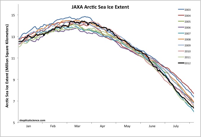
Figure 2: Arctic sea ice extent from 01 January to 04 August, for 2003 through 2012, data from JAXA.
Thus we see that Arctic sea ice in 2012 was experiencing substantial decline even before the Arctic storm hit.
Comments from Arctic Experts
Several Arctic sea ice experts have weighed in on the record-breaking minimum in 2012 and the effects of the summer storm on this record. According to NSIDC Director Mark Serreze,
"The previous record, set in 2007, occurred because of near perfect summer weather for melting ice. Apart from one big storm in early August, weather patterns this year were unremarkable. The ice is so thin and weak now, it doesn't matter how the winds blow."
NSIDC scientist Walt Meier said,
"...in the context of what's happened in the last several years and throughout the satellite record, it's an indication that the Arctic sea ice cover is fundamentally changing....The Arctic used to be dominated by multiyear ice, or ice that stayed around for several years. Now it's becoming more of a seasonal ice cover and large areas are now prone to melting out in summer."
Dr. Julienne Stroeve (another NSIDC scientist) said,
"The acceleration of the loss of the extent of the ice is mostly because the ice has been so thin. This would explain why it has melted so much this year. By June the ice edge had pulled back to where it normally is in September,"
"The 2007 record was set when you had weather conditions which were perfect for melting. This year we didn't have those. It was mixed. So this suggests the ice has got to a point where it's so thin it doesn't matter what the weather is, it's going to melt in the summer. This could become the new normal"
Claire Parkinson, a climate scientist at NASA Goddard Space Flight Center said,
"The storm definitely seems to have played a role in this year's unusually large retreat of the ice. But that exact same storm, had it occurred decades ago when the ice was thicker and more extensive, likely wouldn't have had as prominent an impact, because the ice wasn't as vulnerable then as it is now."
Paul A. Newman, chief scientist for Atmospheric Sciences at NASA's Goddard Space Flight Center estimated that there have been about eight storms of similar strength during the month of August in the last 34 years of satellite records - one every 4 to 5 years.
How Strong was the 2012 Storm?
While the 2012 Arctic storm was a strong one, as Newman noted, it was not unprecedented. To confirm Newman's claim, we examined daily surface pressure maps from NCEP-NCAR and NCEP-II DOE reanalysis data. Low pressure systems are typically associated with a tight pressure gradient that results in strong surface winds.
In the 34 years between 1979 and 2012, we identified 19 deep low pressure systems (defined here as having a central pressure less than 980 hectopascals [hPa]) in the Arctic between 15 July and 15 September. Most of these deep lows occurred over the Barents, Laptev, and Kara seas, so they are not suitable analogs for the 2012 storm.
However, there were five previous storms during this timeframe similar to the 2012 event, occurring near the center of the sea ice pack. These occurred in 1980, 1990, 1991, 1994, and 1997 (Figure 3 - click for a larger version).
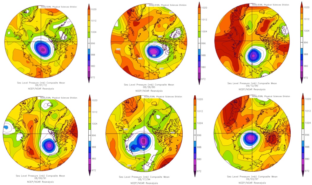
Figure 3: NCEP/NCAR sea level pressure maps in (from right to left and top to bottom) on 07 August 2012, 28 August 1980, 12 September 1990, 06 August 1991, 17 August 1994, and 03 September 1997.
What Effect Did Similar Previous Storms Have on Sea Ice Extent?
If this type of deep Arctic storm has a major influence on annual Arctic sea ice minimum as claimed by contrarians, then we would expect to see similar declines in 1980, 1990, 1991, 1994, and 1997. Let's see what the data shows (Figure 4).
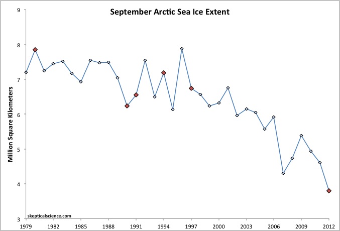
Figure 4: September Arctic sea ice extent data from NSIDC (blue), years with Arctic summer storms similar to the 2012 storm noted in red.
There was a decrease in September Arctic sea ice extent from 1989 to 1990 and 1996 to 1997 (and of course from 2011 to 2012), but an increase from 1979 to 1980, from 1990 to 1991, and from 1993 to 1994. Half increases and half decreases in September Arctic sea ice extent during one of these summer Arctic storm years compared to the prior year - thus no clear sign that these storms had a big impact on sea ice extent.
We should also note that the Arctic storm in 1990 occurred on 12 September, just days before the annual minimum, and there was very little sea ice decline between 12 September and the minumum that year. Thus the 1990 storm cannot be responsible for most of the sea ice decline between 1989 and 1990. In fact, there wasn't a particularly large decline between the date of any of the Arctic storms and the annual minimum, with the exception of 2012.
Figure 5 shows the change in sea ice extent at the time of the summer storm (left frame) vs. the annual minimum (right frame) for each of these years (note that the year in the date on the right frame in Figure 5 is cut off - the year is the same as in the left frame).
Figure 5: Arctic sea ice extent maps on the date of each summer Arctic storm in 1980, 1990, 1991, 1994, 1997, and 2012 and at the annual minimum each of these years.
Thus in the five previous examples of summer Arctic storms similar to that in August 2012, there was no clear impact on the final Arctic sea ice minimum.
Additionally, Screen et al. (2011) found that it was the frequency of cyclones between May and July, and not those in August or September, that are responsible for conditioning the sea ice in September for either a significant loss or gain over the previous year.
So What Factors Contributed to the 2012 Record?
As the ice experts mentioned above, the 2012 summer storm very likely made an already bad situation worse. The reason is that because of the long-term decline and thinning of the Arctic sea ice in response to the dramatic warming, the ice pack is now very vulnerable to events that would have historically had little or no impact.
Not only does the earlier retreat of the sea ice result in a positive feedback, it also means that when there are storms such as in 2012, the winds are capable of generating large swells that can penetrate hundreds of kilometers into the pack and break up the sea ice, thereby hastening the decline. Figure 6 shows the long fetch (the distance along which the winds are able to interact with the ocean surface and produce wind waves and swells) available to winds during the 2012 storm. These conditions were ideal for generating large swells.
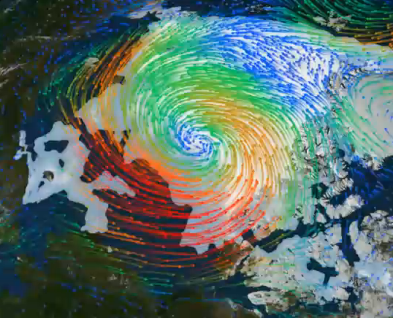
Figure 6: Wind field (coloured arrows, with warm colours representing strong winds) and sea ice (grey areas) on 9 August 2012. Credit: NASA/Goddard Science Visualization Studio.
A similar event was witnessed by Canadian scientists aboard an ice breaker in the Beaufort Sea in September 2009 (Asplin et al. 2012). They observed swells over 250 kilometers (km) from the ice edge following the transit of two lows across the Arctic Basin in short succession. The large swells caused the breakup of large (>1 km) multi-year ice flows up to 5 meters thick, into much smaller flows (100-150 meters). On that occasion the long stretch of open water was also key in permitting the storms to generate a large swell.
Peer-Reviewed Literature on Arctic Storms
We might also ask whether these summar Arctic storms have become stronger and/or more frequent, and if so, why?
Hakkinen et al. (2008) analyzed the wind stress data from the NCEP/NCAR reanalysis to test for a change in Arctic storm intensity/frequency and found that summer storms are becoming more intense (Figure 7).
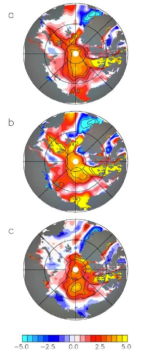
Figure 7: Trends of the NCAR/NCEP Reanalysis wind stresses for 1948–2006 for (a) annual, (b) winter, and (c) summer values. Units are 10-4 N/m2 per year. Figure 3 from Hakkinen et al. (2008).
The authors conclude that the increasing Arctic wind stress trend in the summer has higher significance than the winter trend due to enhanced storminess.
"Our results show a gradual acceleration in sea ice drift over the 50 years analyzed. The accelerating trend in the central Arctic is present both in winter and summer observations, with nearly equal statistical significance. Since the atmosphere is responsible for the main forcing of the sea ice, the obvious conclusion is that the increased sea ice speeds relate to increased storm frequency and/or intensity."
Long and Perrie (2012) investigated the impacts of increased open water in the Beaufort Sea for a summer Arctic storm in 2008 using a coupled atmosphere-ice-ocean model. They found that a reduction in ice cover and more open water results in stronger Arctic storms.
"The model simulations suggest that the lack of ice cover in the Beaufort Sea during the 2008 storm results in increased local surface wind and surface air temperature, compared to enhanced ice cover extents.... These changes result in enhanced surface winds, by as much as ∼4 m/s during the 2008 storm, compared to higher ice concentration conditions (typical of past decades)."
Screen et al. (2011) found no significant trends in late spring or summer Arctic cyclone frequency over the period 1979–2009. So it appears that the intensity of summer Arctic storms may be increasing due in part to the reduction in sea ice cover, which is primarily human-caused, but there is no clear indication of an increase in Arctic storm frequency.
Peer-Reviewed Literature on the Long-Term Sea Ice Decline
As noted above, the long-term thinning and decline of the Arctic sea ice allowed the 2012 summer storm to impact this year's record minimum. Thus it's also important to note that there is very strong evidence in the peer-reviewed literature that the long-term sea ice decline is primarily human-caused. For example, Day et al. (2012) concluded,
"despite increased observational uncertainty in the pre-satellite era, the trend in [Arctic sea ice extent] over this longer period [1953–2010] is more likely to be representative of the anthropogenically forced component."
Stroeve et al. (2012) concluded,
"Based on the CMIP5 multi-model ensemble mean, approximately 60% of the observed rate of decline from 1979–2011 is externally forced"
While Notz and Marotzke (2012) found very poor correlation between oceanic cycles and sea ice extent, but very good correlation between CO2 and ice extent (Figure 8).

Figure 8: Correlation between September sea ice extent and CO2 forcing (red), solar forcing (blue), PDO index (green), and AO index (yellow). Figure 4 from Notz and Marotzke (2012).
And based on the results of Vinnikov et al. (1999), there is less than 0.1% probability that the long-term decline in Arctic sea ice extent is due solely to natural variability.
Summary
The 2012 summer Arctic storm simply cannot be blamed for the record-shattering Arctic sea ice extent minimum.
- Arctic sea ice extent was already declining rapidly prior to the storm formation, to the second-lowest level on record.
- The scientific literature shows that the Arctic is undergoing a fundamental change, with the remaining ice continually becoming thinner, weaker, and more vulnerable, and that this decline is primarily human-caused.
- Sea ice experts agree that unlike in 2007, the 2012 Arctic weather conditions were not ideal for melting ice, and while the the summer storm played a part in the record minimum, it was not the main cause.
- In the past, Arctic summer storms similar to the 2012 event did not have a major impact on sea ice extent or September sea ice minimum.
- The 2012 record-breaking minimum can be attributed to a number of factors. The summer storm likely played a role, but primarily because the ice was thinner, weaker, and less extensive to begin with than in prior years due to its long-term human-caused decline.
- The scientific literature indicates that Arctic storms may be becoming more intense, in part due to increased open water as the sea ice continues its long-term human-caused decline.
Updated on 2012-10-10 by dana1981.


THE ESCALATOR

(free to republish)