Climate Science Glossary

Term Lookup

Enter a term in the search box to find its definition.

Settings

Use the controls in the far right panel to increase or decrease the number of terms automatically displayed (or to completely turn that feature off).

Term Lookup

Settings


All IPCC definitions taken from Climate Change 2007: The Physical Science Basis. Working Group I Contribution to the Fourth Assessment Report of the Intergovernmental Panel on Climate Change, Annex I, Glossary, pp. 941-954. Cambridge University Press.

Home Arguments Software Resources Comments The Consensus Project Translations About Support

Bluesky Facebook LinkedIn Mastodon MeWe

Twitter YouTube RSS Posts RSS Comments Email Subscribe


Climate's changed before
It's the sun
It's not bad
There is no consensus
It's cooling
Models are unreliable
Temp record is unreliable
Animals and plants can adapt
It hasn't warmed since 1998
Antarctica is gaining ice
View All Arguments...


Username
Password
New? Register here
Forgot your password?

Latest Posts

Archives

Poleward motion of storm tracks

Posted on 6 June 2011 by Ari Jokimäki

A new study (Bender et al.) analysing cloud cover measurements has noted storm tracks and the cloudiness related to them migrating polewards during the last few decades. Additionally, storm tracks seem to have become narrower. Observed changes in cloudiness have an amplifying effect to global warming.

In mid-latitudes of both hemispheres there is a region where large-scale atmospheric wave activity transfers heat and moisture polewards. This causes a band of low-pressure systems, where cloudiness and rainfall is common. These bands are called storm tracks. Storm tracks are an important part of weather system, and they also have an effect on climate by their radiative cooling. They also have an effect on large scale weather patterns (for example on North Atlantic Oscillation and on El Niño).

Based on the simulations of climate models, storm tracks should move towards the Earth's poles when climate warms. However, the expected change is so small that it is still difficult to observe it at this time. Despite numerous studies, it is not clear exactly why the storm tracks move polewards in models. Greenhouse gas warming is probably one factor, but aerosols might also be involved.

A new study seeks to find out if the shifting of storm tracks is already evident in the cloud cover measurements of last few decades. The study used ISCCP (International Satellite Cloud Climatology Project) measurements between 1983 and 2008. During that time, global surface temperature has risen about 0.5°C, mich might be big enough for the detection of storm track shifting. Study also used data from some other sources (ERBE, CERES, and MODIS). Additionally, the situation was simulated with climate models.

ISCCP problems

There are known errors in ISCCP data; in particular the changes in satellite viewing angle makes the interpretation of the data problematic. It seems that these days every new study using ISCCP data is also a study on satellite viewing angles. Satellite viewing angle changes when a satellite is added to the satellite network, satellite location is changed, or a satellite is removed from the network. A change in the viewing angle affects the amount of measured cloudiness. A proper solution to the problem does not exist yet, but this study makes an effort to go around the problem with couple of different methods.

The easiest method for going around the problem is to leave out the data from those regions which are affected the most. The weakness of this method is that the problem still exists in other regions at least to some extent. In this study, the region of Indian Ocean was left out because it was between the borders of the measuring areas of two satellites and there were no supporting data available from other satellites before 1997.

The effects of satellite network changes can potentially be removed through regression analysis. This method was used on the global cloud data over the oceans. After the correction, the decreasing cloud cover trend in ISCCP data got smaller from 1.5% to 0.4 % per decade. In the storm track areas, the effect of the correction is smaller.

Satellite viewing angle problems are especially bad in thin clouds because they can easily fall out of detection limit after viewing angle change. It might be possible to reduce the problem by concentrating on thick clouds only, but this method has its own problems, and the method doesn't give truthful picture of total cloudiness.

Shifting of storm tracks

Studied storm track regions show clear cloud maxima which can have over 90% average annual cloud cover. Observations also show a poleward shifting of storm tracks during the last 25 years. Shifting has been stronger on the equator side of storm tracks, which has caused a narrowing of the storm tracks. All studied regions show similar changes in storm tracks. Narrowing of storm tracks is especially strong in the North Atlantic, which may suggest that the region is strongly affected by the satellite viewing angle problem, which also was to be expected beforehand.

Latitudinal shifts of cloudiness in four studied storm track regions.

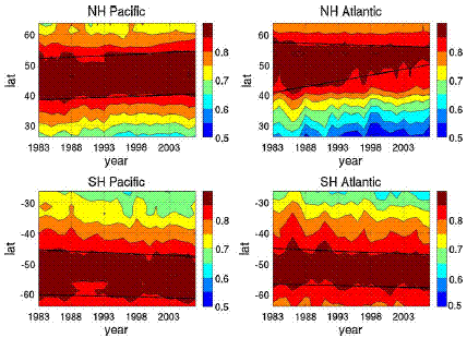
Figure 1. Latitudinal shifts of cloudiness in four studied storm track regions.?

In ISCCP data, storm tracks have shifted 0.15 – 0.17 degrees of latitude per decade in other regions except in North Atlantic, where again is anomalously large change (0.6 degrees of latitude per decade).

With storm track shifting there is an associated decrease in cloudiness in storm track areas. Observations show a couple of percent decrease in cloudiness in storm track areas (and again North Atlantic has clearly bigger change). Most of the cloud cover decrease occurs in low clouds. Middle clouds and high clouds have even increased slightly.

The climatic effect of storm track shifting

The changes in longwave and shortwave radiation (measured in ERBE and CERES projects) correlate with cloudiness sufficiently well, that the effect of clouds to radiative fluxes can be estimated from ISCCP data. In the case of shortwave radiation, clouds change the radiative flux by reflecting the radiation from the Sun back to space. The effect to shortwave radiation can be seen in the data especially in the storm track areas. Clouds affect the radiative flux of the longwave radiation through their greenhouse effect, which also is seen in the data.

 Cloud fractions of low, middle, and high clouds in the four storm track regions.

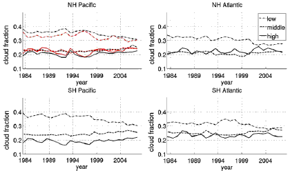
Figure 2. Cloud fractions of low, middle, and high clouds in the four storm track regions. Upper left panel red lines represent western NH Pacific.

Total cloudiness has decreased 2-3% in storm track areas. This has caused the reflected solar radiation to decrease, which means that in storm track areas more solar radiation reaches the Earth's surface. This change causes a warming effect (of about 3 watts per square meter). Middle and high clouds have increased by 2-5%. This reduces the outgoing longwave radiation, which means that bigger part of longwave radiation stays on Earth and causes warming (of about 1 - 3 watts per square meter).

The changes in cloudiness cause a warming effect both by longwave and shortwave fluxes (total effect is about 3 to 5 watts per square meter). Therefore it seems that cloud changes in storm track areas have amplified global warming (this is so called positive feedback). However, this result doesn't necessarily reflect the global situation, because possible compensating effects in other areas were not studied. Additionally, ISCCP data problems may contribute to the situation considerably. For example, without thin clouds, even a small negative feedback is possible (total effect in this case is -1 to 2 watts per square meter, so even in this case the most probable value of feedback is positive, even if uncertainty bars allow the possibility of a small negative feedback).

20 climate models were investigated, and seven of them showed poleward storm track shifting with global warming. However, the amount of shifting was considerably smaller than what ISCCP data shows. In the models where storm tracks shifted the most, meaning that they were closest to observations, climate sensitivity was greatest. Models with climate sensitivity less than 3 °C don't even show statistically significant storm track shifting in all storm track areas. This suggests that also model results support positive cloud feedback associated with storm tracks.

Reference: Frida A-M. Bender, V. Ramanathan and George Tselioudis, Changes in extratropical storm track cloudiness 1983–2008: observational support for a poleward shift, Climate Dynamics, DOI: 10.1007/s00382-011-1065-6. [abstract]  

Additional information:

- Viewing Angle on ISCCP Problems

- Papers on Hadley Cell expansion

0 0

Printable Version  |  Link to this page

Comments

Comments 1 to 19:

  1. And of course this isn't an isolated phenomenon though relevant in our latitudes... a small tornado observed just yesterday at ~62N. Hadley cell response: http://citeseerx.ist.psu.edu/viewdoc/download?doi=10.1.1.143.9016&rep=rep1&type=pdf storm intensification over southern ocean: http://www.nature.com/ngeo/journal/v1/n12/abs/ngeo362.html
    0 0
  2. Can someone translate .16 degrees/decade into miles on the ground/decade? Thank you.
    0 0
  3. One degree of latitude is about 60 nautical miles (it depends a bit on latitude) which translates into about 69 miles.
    0 0
  4. Thank you Riccardo. So storms are moving 11 miles north per decade (assuming all the caveats in the above review resolve out to this paper getting it right). Interesting. I live in the Southwest - and storms moving 40-50 miles north would change things a LOT in this area of the country.
    0 0
  5. Isn't this the general effect that was mentioned in the documentary "Insidious Soup" about aerosols, that was theorized to have caused a big drop in rainfall in sub-Saharan Africa? This is the part of our messing with the composition of the atmosphere that worries me the most -- we've been doing it for a long time, we're doing it at an alarming rate right now, and we're just starting to figure out what we've set in motion.
    0 0
  6. Details, details. "the region is strongly infected" should be affected - in the first para of the Shifting of Storm Tracks section. And latitudes is more correct than latidudes. Though I do think geographers or meteorologists should immediately adopt lati-dudes as a club name.
    0 0
  7. Wait, an increase in hight altitude clouds would't mean a negative feedback since they reflect more sunlight into space?
    0 0
  8. @adelady #6 Kudos for bringing some wry humor to this comment thread.
    0 0
  9. @7 Daneel No high clouds are more efficient at trapping heat. See here Cirrus clouds efficiently absorb outgoing infrared radiation beneath them (this is otherwise known as the greenhouse effect), while only marginally reflecting the incoming sunlight.
    0 0
  10. "Though I do think geographers or meteorologists should immediately adopt lati-dudes as a club name." Or cartographers.
    0 0
    Response:

    [DB] As a nautical cartographer, our softball team was called "Slack Tide".  Had we even thought of "lati-dudes" perhaps we would have gone with that instead.

  11. An interesting oservation (to me), from the much maligned 'climatologist' Iben Browning - was perspective. If 'weather' was observed from a polar perspective, rather than from the equator - there is normally a 'four-leaf clover' of polar highs, that rotates around the poles - that takes, on average 6 - 8 days to pass a lower latitude location (and persists), but very infrequently, shifts by a day. The most notable observation - is 'rotten weekends' for an extended time, until a 'shift', as the 'average' of 6 - 8 days is a week! 'I have observed' and 'predicted' rain occurring, on Friday, Saturday, or Sunday - at the (Montreal) Canadian GP (event), more 'accurately' than the pre-event, weather forcasters. 'My prediction' has persisted longer than 4 years - in the sense of rain on Friday, Saturday or Sunday vs No Rain for the event, or rain, ending Thursday or post event on Sunday night! I know this is not very exact, but (for me) much better than the weather forcasters 'from the equator perspective'! This year, rain is likely race day maybe after the race.
    0 0
  12. Thanks for a very interesting post.
    0 0
  13. @9 Ron Crouch. Thanks!
    0 0
  14. "Despite numerous studies, it is not clear exactly why the storm tracks move polewards in models." Mid latitude cyclones are inherent it the earth's climatic zones. It has been a first principle of climatology for a very long time that these zones migrate poleward in the summer and equatorward in the winter. It follows, and has been a first principle of paleoclimatoly and paleoecology since at least the early 20th century that climatic and ecological zones migrate poleward (and higher in altitude on mountains)during warm periods in earth history. The attribution may be disputable, but very few reasonable people dispute that we have been in a warming trend, and the models certainly predict this warming trend, so it should be no surprise that the models predict a poleward movement of the storm tracks, nor that such movement has been observed.
    0 0
  15. Given the innaccuracies due to satelite viewing angles and cloud thickness, how confident can we be storm track data? Yes, the trend would fit well with climate theory but I'm not sure how confident we be at this point in time. Would we not need a better method of measurement over a significant period of time to draw any real conclusions here?
    0 0
  16. Stevo #15, in my opinion, the size of the effect might not yet be very certain but it seems that the effect is ongoing. There are some other studies showing that Hadley Cell is expanding and that supports the results of this study. Additionally, also another study (Zhou et al. 2011, also full text is available) published recently gave very similar results to this study. So, I think it is quite safe conclusion that this study along with other studies seem to give a robust picture of atmospheric zones travelling polewards. How fast they are travelling might be more uncertain.
    0 0
  17. Some more talk of other recent papers at http://rabett.blogspot.com/2011/06/eli-is-evil-bunny.html , maybe relevant to this, or, the whole atmospheric circulation.
    0 0
  18. Ari #16. Thankyou Ari, for the links. The case certainly looks firmer than I first thought.
    0 0
  19. The observed poleward shift of storm tracks was shown in the poleward shift of polar cells from 45-50deg latitudes to 50-55deg. This coincided with the Antarctic circumpolar channel resulting in increased circumpolar currents, upwelled deep water off Antarctica and northward driven surface waters up the Atlantic. See J. R. Toggweiler & Joellen Russell Ocean circulation in a warming climate Nature 451, 286-288 (17 January 2008) doi:10.1038/nature06590 Figure 2 in Togweiler and Russel clearly shows the increased gradient at the top of the troposphere and the poleward shift of the circulation cells. We have sailed our boat in the Irish and North seas for the past 20 years. We always tried to get to port before the equinoctial storms with maximum winds in September. Now, though there are odd days with 30kt winds in August and September, March and April, days with 40kt occur around 6 weeks either side the winter solstice; (17 November 2010 (42kt) and 15 January 2011 (40kt) at Ronaldsway, Isle of Man at the hub of the Irish Sea). The work reported here and by Toggweiler and Russell seems to confirm our observations at 54deg N latitutude.
    0 0

You need to be logged in to post a comment. Login via the left margin or if you're new, register here.


The Consensus Project Website

THE ESCALATOR

(free to republish)


© Copyright 2024 John Cook
Home | Translations | About Us | Privacy | Contact Us