Submerged Forests off the coast of Wales: a Climate Change Snapshot
Posted on 7 April 2012 by John Mason
Sea-level rise over the past 10,000 years is recorded in Cardigan Bay, off the western seaboard of Wales, UK. Peat-beds complete with the remains of trees are today exposed over low tide along several of the Bay's beaches. Incredibly, a new exposure of peat has recently yielded human footprints, made some 3000 years or more ago by the people who witnessed the final stages of the drowning of the land.
The deglaciation that followed the Last Glacial Maximum, twenty thousand years ago, was accompanied by a global sea-level rise that averaged out at some 120 metres. Around the British Isles, there are many areas covered by shallow seas, 10-20 metres in depth, and Cardigan Bay, off the west-facing coast of Wales, is one of them. Sailing due west from the local coastal ports such as Aberystwyth and Aberdyfi, it is a good ten nautical miles before the 20m submarine contour is reached. The sea-bed is a sandy table-land, divided by several great ridges of gravel and boulders - the Sarnau (Welsh for Roads) - that mark the lateral moraines of the valley-glaciers that flowed out westward to join the Irish Sea Ice-Sheet.
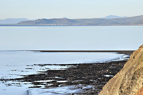
above: view across Cardigan Bay to the Snowdonia mountains, with one of the Sarnau, Sarn Cynfelyn, in the foreground. It extends out beneath the sea as a steep-sided reef for over six nautical miles. Photo: author.
The process of post-glacial sea-level rise has been well-charted, and with respect to this corner of the world, the inundation of the land to form much of Cardigan Bay was within the last 10,000 years. We have additional local evidence for this timescale: peat samples, dredged from the seabed not far from Aberystwyth, at a depth of 18.5 metres, yielded a radiocarbon date of 8740 +/- 100 years before present (Haynes et al, 1977). It should be noted in passing that this part of the UK is regarded as having been essentially neutral with respect to post-glacial isostatic rebound: to the north, where the main ice-sheets were formerly located, the land rose whilst to the south, which was mostly ice-free, the land sank.
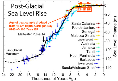
above: the post-glacial rise in sea-level, adapted from Fleming et al (1998), with dates relevant to this article annotated in red.
8740 years: let's just place that date in context. The Younger Dryas had come and gone (12,900-11,800 years BP), and the Mesolithic was about halfway through. The people who lived in the region were gradually turning from full-time hunter-gatherers to the combination of these with agriculture, something which by the Neolithic was developing various degrees of sophistication. By then, the rate of sea-level rise had slowed, but it continued to advance throughout the Neolithic and the following Bronze Age, and there is impressive evidence from that process right here on the Welsh coast.
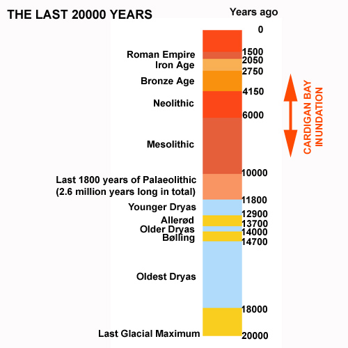
above: timeline annotated with the period during which Cardigan Bay was inundated.
So-called Submerged Forests are known from various parts of the world, but the one at Borth, on the Cardigan Bay Coast of Wales, is a particularly fine example. Every winter, after storms have scoured away parts of its extensive sands, large areas of peat appear, littered with fallen tree-trunks and with stumps in growth position. Although it is sometimes referred to as the "Fossil Forest", the wood is not fossilised as such: it looks and feels just like what one might expect waterworn and waterlogged wood to look and feel like. The peat is hard and compact: walking on its surface barely leaves a mark.
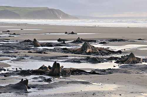
above: part of the Submerged Forest at Borth. Photo: author.
The basal peat, upon which the tree-stumps are situated, is around 6,500 years old. Above it, where erosion has not removed it, there lies a layer of bluish-grey clay and, at the south end of the beach, atop the clay is a second, thinner peat. The succession records the transition from forest to salt-marsh, between 6,500 and 3,000 years ago, which is late Mesolithic through to mid Bronze Age. It is thought that, originally, the coastline, with its shingle storm-beach and dunes, was over a kilometre to the west (seawards): during this period, the storm-beach advanced towards the land and its immediate hinterland became salt-marsh: the trees became waterlogged with brackish water and died. The retreat of the coast would likely have continued were it not for the establishment of the fishing-village of Borth and various sea-defences, the most recent of which is just nearing completion. Local people living here are constantly reminded of sea-level rise when they look out across the beach at low tide and see the trees emerging from the waves.
The Submerged Forest has recently been in the news. In February 2012, retired geology lecturer Dr Denis Bates, of Aberystwyth, noticed that a new area of ancient peat had become visible along the southernmost part of the beach. Taking a closer look, he discovered that the peat contained scatters of burnt stone - an archaeological feature typical of Bronze Age sites. Burnt stone consists of sharp, angular fragments of bleached-looking rock produced by heating large pebbles in fires and then immersing them in water: it was the instant cooling that shattered them. Why they did this is not clear: one theory is that it was a means of heating-up the water whilst some archaeologists have connected the practise with sweat-lodges, as in the Native American tradition.
Dr Martin Bates, Denis' son, is an archaeologist based at the University of Wales, Lampeter, and was therefore quickly on hand to undertake a detailed investigation of this find. Despite the peat and clay beds spanning an important period of human activity in the area, they have to date yielded few remains: an Aurochs skeleton was discovered many years ago and a small number of flint and bone implements have been recorded over the years. But when surveying commenced, the site proved to be of even greater interest, as upon the surface of the upper peat layer, and impacting into the clay below, the surveyors discovered footprints. There were the circular depressions made by the hooves of cattle, sheep and goats and, incredibly, human prints. It appears that the adults were foot-clad, but one print was found that belonged to a child aged approximately four years, which showed the impressions of bare toes. I visited the site over low tide a few days ago: standing next to such impressions, my heavy rigger-boots hardly left a mark: back when the prints were made this would have been squelchy marsh that you could go up to your knees in if unlucky.
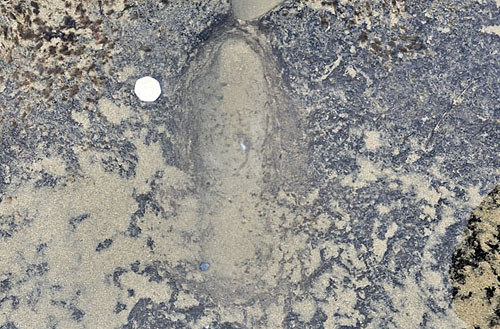
above: photographed whilst still underwater, a human footprint in now hard and compact peat at the Submerged Forest, Borth. Photo: author.
Interestingly, coastal West Wales has its very own Flood Legend, which goes as follows:
Cantre'r Gwaelod (also known as Cantref Gwaelod or Cantref y Gwaelod) translates into English as the Lowland Hundred. It is the legendary sunken kingdom that is said to have long ago occupied a tract of fertile land in what is now Cardigan Bay. Cantre'r Gwaelod's capital was Caer Wyddno, seat of the ruler Gwyddno Garanhir. The land is usually described as being defended from the sea by a dyke, complete with sluice-gates, managed by one Seithennin, who, it was said, was fond of his drink. One dark and stormy night, the gates were neglected during drunken festivities and as the tide rose, so the sea swept in, ruining the land.
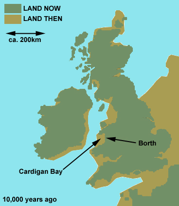
above: lost landscapes? A map of the UK, Ireland and N France ten thousand years ago, at the start of the Mesolithic, when sea levels, though rising, had not yet reached their full post-glacial extent. The brown areas are lands that have since been lost. Redrawn from Lambeck, 1995 (PDF).
Mere folklore, yes, but it is often wondered locally whether the legend recalls stories handed down over many generations, via the oral tradition, of lands that produced good hunting and gathering, but which by the start of the Neolithic had largely been lost to the advancing sea. The generations of people who followed-on from those who left the footprints would certainly have witnessed the environmental changes that led to the loss of the forests described above: they would have walked through what had become salt-marsh beneath dead and dying oaks and pines. They would have seen environmental change as starkly as anyone.
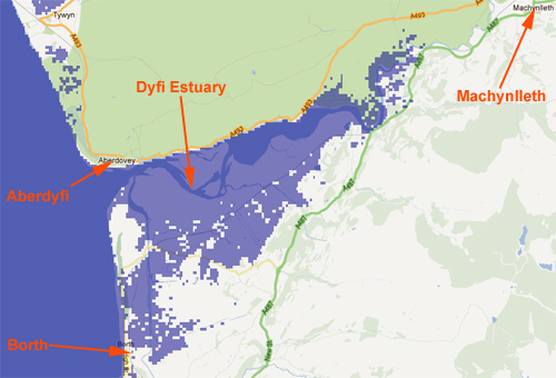
So what is in store for this small corner of the planet in the coming decades? According to Vermeer and Rahmsdorf (2009), the worst-case scenario would be a rise of 190cm by 2100. Using Alex Tingle's handy plotter, this is what a rise of 2m would look like:
And a rise of 6m, which would occur if parts of both the Greenland and West Antarctica ice-sheets continued to melt, would look like this:
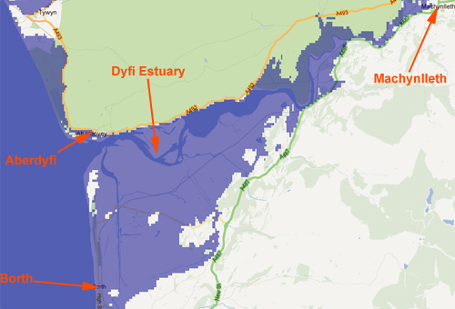
Borth and Aberdyfi would be overwhelmed and even my hometown some distance inland would be affected: the fertile agricultural lands along the Dyfi flood-plain would be replaced by the relatively poor grazing offered by salt-marsh and another legend of flood would be born. Being rather fond of these places and the communities that live in them, I would personally prefer an outcome that did not involve such inundation. Future generations have just as much right to enjoy them as I do at present. It is such considerations that come to mind when people ask me why I blog.


 Arguments


John, I'm a radio producer in the states and I'm putting together an idea for a podcast about the cultural dimensions of climate change. I'd love to interview you for it and talk about Cantre'r Gwaelod. I'm at kristinmoe3@gmail.com. Please send me an email if you'd be willing to chat with me. Thanks!
Kristin Moe
Kristinmoe,
John Cook rarely posts here anymore. You might try searching for his email address on GOOGLE. He currently works for George Mason University.
[JH] John Cook has returned to Australia for a vacation visit. The best way to communicate with him is by using the "Contact US" button at the bottom of this page.
[BW] As Kristinmoe's comment is on a post written by John Mason in 2012, I guess that it's him she'd like to contact. I already let him know about the comment and he'll be in touch with her.