


 Arguments


Forecasters predict an above-average Atlantic hurricane season in 2021
Posted on 13 April 2021 by Guest Author
This is a re-post from Yale Climate Connections by Jeff Masters, PhD
An above-average Atlantic hurricane season is likely in 2021, the Colorado State University (CSU) hurricane forecasting team says in its latest seasonal forecast issued April 8.
Led by Dr. Phil Klotzbach, with coauthors Dr. Michael Bell and Jhordanne Jones, the CSU team is calling for an Atlantic hurricane season with 17 named storms, 8 hurricanes, 4 intense hurricanes, and an Accumulated Cyclone Energy (ACE) of 150. In comparison, the long-term averages for the period 1981-2010 were 12.1 named storms, 6.4 hurricanes, 2.7 intense hurricanes, and an ACE of 106.
The CSU outlook predicts the odds of a major hurricane hitting the U.S. to be 69% (long-term average: 52%). It gives a 45% chance for a major hurricane to hit the East Coast or Florida Peninsula (long-term average: 31%), and a 44% chance for the Gulf Coast (long-term average: 30%). The Caribbean is forecast to have a 58% chance of seeing at least one major hurricane (long-term average: 42%).
The CSU forecast uses a statistical model honed from 38 years of past Atlantic hurricane statistics, plus output from the ECMWF (European) model to augment the statistical technique.
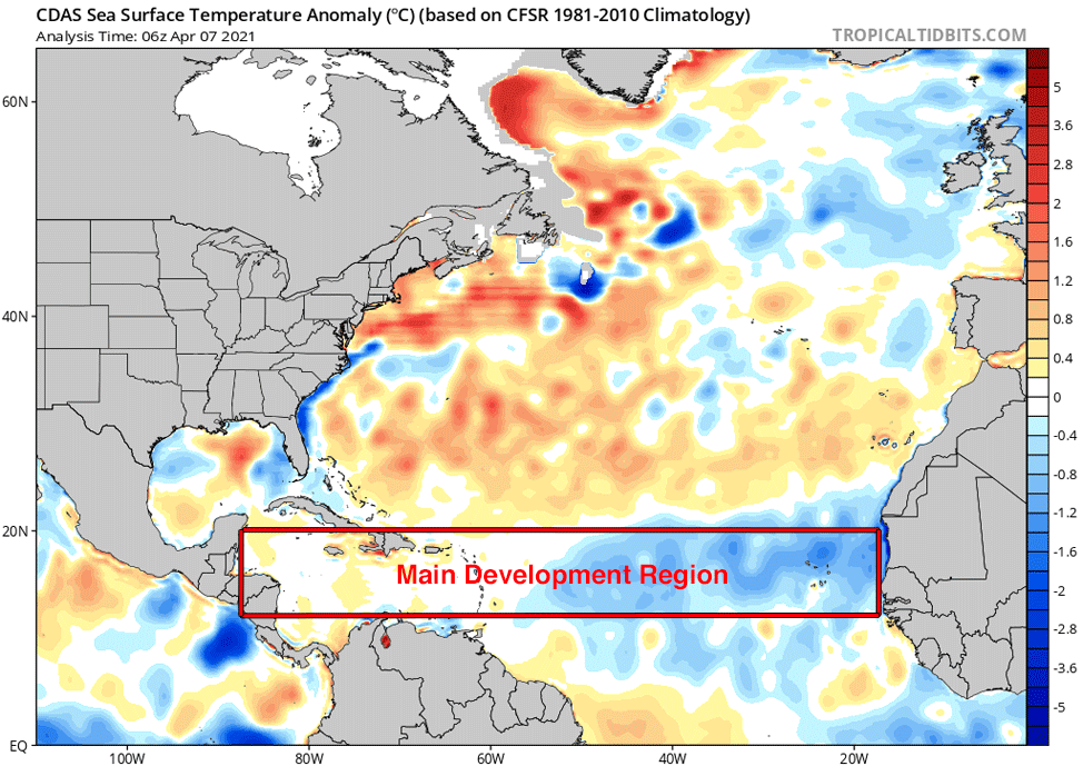 Figure 1. Departure of sea surface temperature (SST) from average for April 7, 2021. SSTs were well above-average in the subtropical Atlantic. In the hurricane Main Development Region (MDR) between Africa and Central America, SSTs were average or above average in the Caribbean, and below average in the eastern Atlantic. Virtually all African tropical waves originate in the MDR, and these tropical waves account for 85% of all Atlantic major hurricanes and 60% of all named storms. Much above average SSTs in the MDRR during hurricane season generally lead to a very active season in the absence of an El Niño event. Conversely, when MDR SSTs are cooler than average, a below-average Atlantic hurricane season is more likely. (Image credit: tropicaltidbits.com).
Analogue years
Five years with similar pre-season January, February, and March atmospheric and oceanic conditions were selected as “analogue” years that the 2021 hurricane season may resemble. These years had La Niña conditions the previous winter, and then neutral or weak La Niña conditions during the peak of the Atlantic hurricane season (August-October). The CSU team also selected years that had near- to above-average sea surface temperatures (SSTs) in the tropical Atlantic. The five analogue years were:
1996 (13 named storms, 9 hurricanes, and 6 intense hurricanes);
2001 (15 named storms, 9 hurricanes, and 4 intense hurricanes);
2008 (16 named storms, 8 hurricanes, and 5 intense hurricanes);
2011 (19 named storms, 7 hurricanes, and 4 intense hurricanes); and
2017 (17 named storms, 10 hurricanes, and 6 intense hurricanes).
The average activity for these years was 16 named storms, 9 hurricanes, 5 major hurricanes, and an ACE of 155 – well above the long-term average. (Let’s hope that 2021 does not resemble one of those analogue years chosen, 2017: That year featured three incredibly destructive major hurricanes – Harvey, Irma, and Maria.)
Neutral or weak La Niña conditions …
The CSU team cited two main reasons, addressed below, that 2021 may be an above-average hurricane season:
1) A significant El Niño seems unlikely. El Niño conditions favor a slower-than-usual Atlantic hurricane season as a result of an increase in the upper-level winds over the tropical Atlantic that can tear storms apart (higher vertical wind shear). If neutral or La Niña conditions are present, instead, an active hurricane season would be more likely.
The current weak La Niña event in the Eastern Pacific appears likely to transition to neutral conditions this summer, and NOAA’s Climate Prediction Center (CPC) predicts in its latest April 8 monthly advisory an 80% chance of neutral conditions during the May-July period. The Australian Bureau of Meteorology, which uses a more stringent threshold than NOAA for defining La Niña, says that neutral conditions have already begun.
For September-November, NOAA gives a 40-50% chance that La Niña conditions might redevelop, a 40-50% chance that neutral conditions will prevail, and only a small chance that El Niño conditions might develop.
Sea surface temperatures (SSTs) were about 0.3 degrees Celsius below average during the past month in the so-called Niño 3.4 region (5°S-5°N, 120°W-170°W), where SSTs must be at least 0.5 degrees Celsius below average to qualify as weak La Niña conditions.
Reviewing the latest predictions from a large number of statistical and dynamical El Niño models for the peak of the Atlantic hurricane season in August-October, more than half call for neutral conditions, two predict El Niño conditions, and four predict La Niña conditions.
… and above-average tropical Atlantic SSTs predicted
2) Anomalously warm SSTs are expected in the tropical Atlantic for the peak of the Atlantic hurricane season. SSTs averaged across the tropical Atlantic have been near average over the past month, and subtropical Atlantic SSTs were warmer than average. The current pattern of SSTs and the output from the European model suggest that SSTs will be above average during the peak of hurricane season, favoring an active season.
As is its practice, the CSU team included this standard disclaimer:
“Coastal residents are reminded that it only takes one hurricane making landfall to make it an active season for them, and they need to prepare the same for every season, regardless of how much activity is predicted.”
 Figure 2. Comparison of the percent improvement in mean square error over climatology for seasonal hurricane forecasts for the Atlantic from NOAA, CSU and Tropical Storm Risk (TSR) from 2003-2020, using the Mean Square Skill Score (MSSS). Values less than zero indicate that pure climatology does a better job than the forecast. The figure shows the results using two different climatologies: a fixed 50-year (1951-2000) climatology, and a 10-year 2011-2020 climatology. Skill for forecasts issued in April is close to or below zero, is modest for June forecasts, and is moderate-to-good for August forecasts. Using this methodology, TSR has had the best seasonal forecasts. (Image credit: Tropical Storm Risk, Inc. (TSR))
April hurricane season forecasts have little or no ‘skill’
On average, April forecasts of hurricane season activity have had no “skill,” or even negative skill when computed using the Mean Square Skill Score (Figure 2). A negative skill means that a forecast simply using climatology would do better. April forecasts must deal with the so-called “spring predictability barrier.” In April, the El Niño/La Niña phenomenon commonly undergoes a rapid change from one state to another, making it difficult to predict whether there will be El Niño, La Niña, or neutral conditions in place for the coming hurricane season.
Last year’s CSU April forecast predicted an above-average Atlantic hurricane season for 2020, with 16 named storms, 8 hurricanes, 4 intense hurricanes, and an Accumulated Cyclone Energy (ACE) of 150. The 2020 season ended up with record to near-record activity, with 30 named storms, 13 hurricanes, 6 major hurricanes, and an ACE of 180.
The next CSU forecast, due on June 3, is worth paying more attention to, as late May/early June forecasts have shown considerable skill over the years. NOAA issues its first seasonal hurricane forecast for 2021 in late May. The British private forecasting firm Tropical Storm Risk, Inc. (TSR) is to issue its first 2021 Atlantic hurricane season forecast on April 13.


Comments