


 Arguments


Athabasca Glacier: a tragic vanishing act
Posted on 26 August 2014 by Andy Skuce
The Athabasca Glacier in the Canadian Rocky Mountains is probably the easiest glacier in the world to access by car. It's just a few hundred metres' stroll from the nearest parking lot on the magnificent Icefields Parkway in Alberta. The problem is, the stroll keeps getting longer by about 10 metres every year. Since 1992, the snout of the glacier has retreated about 200 metres, requiring tourists anxious to set foot on the glacier to walk a little further. The glacier has lost about 2 km of its length since 1844 (Geovista PDF).
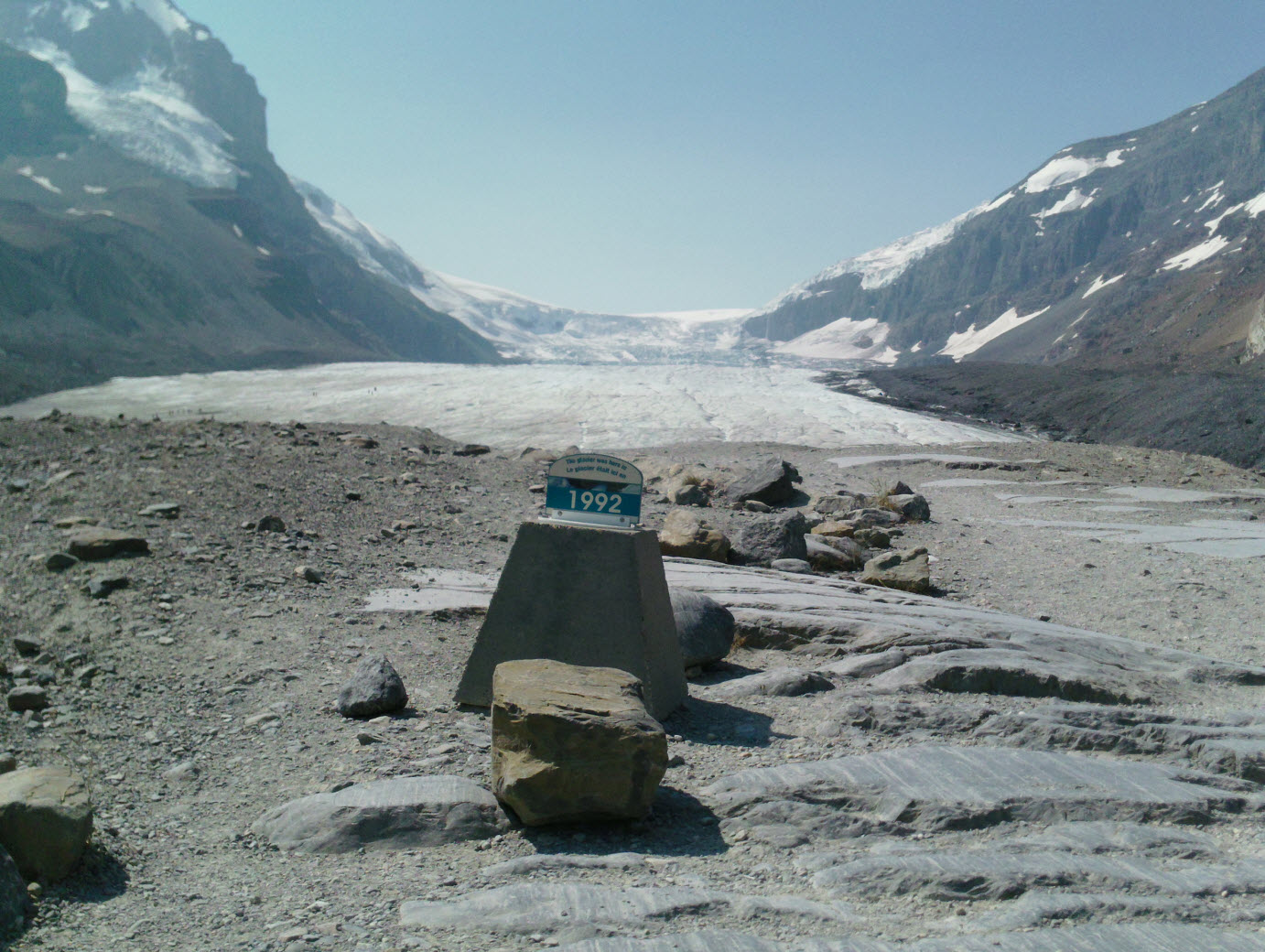
The Athabasca Glacier seen from the access trail. This point is about halfway from the parking lot and the current snout of the glacier, which is about 200 metres away. In the centre background is the ice-fall from the Columbia Icefield. The marker shows where the glacier snout was in 1992, coincidentally the year of the Rio Earth Summit. It is just possible to make out some people walking on the glacier on the left-hand side.Click for big.
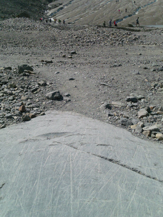
Tourists walking on the glacier snout. Note the striated rocks on the bedrock in the foreground. These striations were caused by rock fragments grinding away at the bottom of the advancing ice through several glacial episodes in the Pleistocene and Holocene. The scratches seen here will likely be the last to form for several tens of thousands years or more.
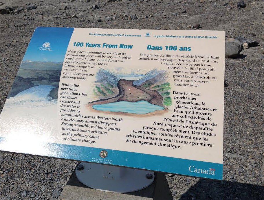
An interpretive sign along the trail to the glacier, by Parks Canada. "Des études scientifiques solides révèlent que les activités humaines sont la cause première du changement climatique." True in both official languages.
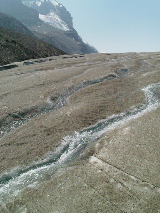
Dirt and rock fragments on top of the ice decrease the albedo of the ice surface, absorbing the August sun. In conjunction with unusually warm summer temperatures, the ice melts quickly.
The meltwater runs down rivulets (about half a metre wide in the photo) on the surface of the ice and down through crevasses to the glacial lake at the snout. The outlet stream of the lake is the source of the Athabasca River, which carves a valley through the mountains and Foothills down to the Great Plains. As it passes through the bitumen deposits of the Athabasca oil sands on its way to the Arctic Ocean, some water is extracted from the river, is superheated by natural gas and injected into the bituminous sandstones to melt the bitumen so that it can flow into well bores and be pumped to the surface. The bitumen is refined to gasoline with the help of more natural gas and is then used, in part, to fuel vehicles that ferry visitors to the Athabasca Glacier. The emissions from these vehicles contribute to the greenhouse gases that are melting the glacier. And so the Anthropocene resource cycle continues, at least for a while longer.
Glaciers vanishing globally
Of course, the Athabasca Glacier is not unique. Most glaciers are rapidly disappearing all over the world. According to Chapter 13 of the latest IPCC report (big PDF) melting glaciers will make up about a quarter of the increased volume of the rising oceans over the rest of this century and about half of the increase in ocean mass. Approximately half of the increase in volume will come from expansion of seawater as it warms. About half of the increase in mass will come from melting of the Antarctic and Greenland ice sheets (counted separately from the mountain glaciers) and from changes in land storage of water. See Table 13.5 for details.
One of the main references used for the IPCC report was a 2012 paper in The Cryosphere by Marzeion, Jarosch and Hofer (open access PDF). They measured and modelled glaciers in several regions around the world and projected glacier melting under the Representative Concentration Pathways (RCP). For RCP 2.6 (the low-emissions pathway), glaciers will contribute 125mm (63-181) to sea-level rise (SLR); for RCP 8.5 (the high-emissions pathway), 185mm (95-255).
The contribution from different glaciated regions for the two extreme emissions scenarios is shown in the figure below.
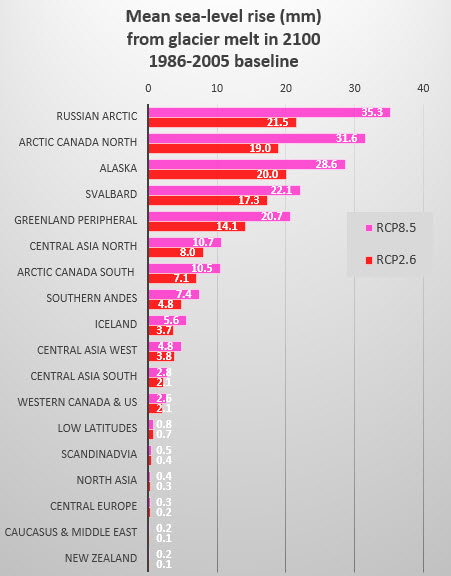
Based on numbers kindly provided by Ben Marzeion. The definition of the regions is shown in this figure.
What is striking is the relatively small difference in most cases in the amount of SLR from glacier melt to 2100 in the two very different RCP scenarios. Part of this is because of the long lag time of glacier response to existing human and natural climate change. We are therefore already locked in to significant glacier ice loss, no matter what we do with emissions over the next few decades. This is particularly true for mountain glaciers in tropical and temperate latitudes.
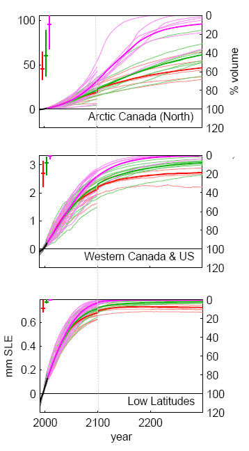
Three regions selected from Figure 23 of Marzeion et al (2012), show mass balance of glaciers out to 2300. The red lines are model runs for RCP 2.6, green for 4.5 and pink for 8.5. "Western Canada & US" excludes Alaska and the Canadian Arctic. "Low Latitudes" includes all of the tropical glaciers of South America, Africa and Indonesia. The amount of sea-level equivalent rise is shown on the left axis and the right axis shows the percentage of ice remaining, relative to a 1986-2005 baseline.
Note that ~80% of the low-latitude ice is gone by 2100 under any scenario. For Western Canada and the US ~60% of the ice will melt under pathway RCP 2.6 and ~80% under RCP 8.5 by 2100. The Arctic glacier ice is more resilient (and voluminous), but even so, more than half of it will melt by 2300. Even if we manage to limit warming to 2°C, we have already locked in the eventual loss of the bulk of the planet's glaciers.
Whodunit?
Glaciers have been observed to be shrinking since the middle of the nineteenth century, long before human-caused climate change became significant. Leclercq et al. (2011) showed that glaciers started melting around 1850 and that the rate of mass loss has remained fairly constant (about 150-400 billion tonnes of water per year according to Figure 4.12 in the IPCC AR5 report Chapter 4) from then until the present day. The world seems to have hit "peak glacier" around 1850 and the loss of glacier ice since then has added roughly 10 cm to global sea levels.
A recent paper by Marzeion et al (2014) in Science (paywalled) attempts to unravel the natural and human contributions to glacier melt. They calculated that without human influences, glaciers would have added 9.9 cm (±3.6) and that with human activities included the figure is 13.3 cm (±3.0). The percentage of human influence varies over time, as shown in the figure below.
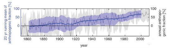
Part of Figure 1 from Marzeion et al. (2014), showing the increasing anthropogenic influence on glacier melt. The blue line is the running 20-year mean of the model ensemble and the shaded blue area is the standard error.
What these results show is that glacier melt was almost exclusively natural up to 1920, after which time the human influence rose steadily as the effects of human-caused climate change started to increase and the natural climate changes resulting from recovery from the Little Ice Age diminished. Currently, the human contribution to glacier melt is about two-thirds (69 ±25%). Through the rest of the 21st Century, the human contribution to the melting of glaciers is expected to increase even more.
Whither the snows of yesteryear?
The glaciers of the temperate and low latitude mountain ranges in the Rockies, the Andes, Alps, Pyrenees, Caucasus, Scandinavia, the African Rift, Indonesia and the Southern Alps are disappearing fast and will be mostly gone by 2100, no matter what we do with future emissions. Even the glaciers of the mighty mountains of South Central Asia, the so-called third pole, will be more than half gone in just a few generations. There is still hope to save about half of the volume of the huge glaciers and icecaps of Alaska and the Arctic provided that we follow a prudent emissions pathway.
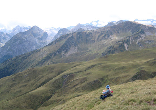
A lunch break on a hike in the Spanish Pyrenees (in 2002). The glaciers in the background on the right are the Aneto and Maladeta glaciers, the largest in the Pyrenees, likely to disappear altogether by mid-century.
Putting aside, for now, the consequences for human and ecological welfare as the glaciers retreat and no longer provide steady water supplies through the summer, the imminent loss of the glaciers in the world's temperate and tropical mountains is a terrible blow to those of us who treasure the mountains for their cultural, recreational and aesthetic value. The glaciers we marvel at will soon be gone and they won't be coming back on any imaginable human timescale. It's a damned shame.
References
Gadd, B. (2011) Athabasca Glacier and Columbia Icefield GeoVistas Brochure,published by the Canadian Federation of Earth Sciences. PDF
Leclercq, P. W., J. Oerlemans, and J. G. Cogley. "Estimating the glacier contribution to sea-level rise for the period 1800–2005." Surveys in geophysics 32.4-5 (2011): 519-535. PDF
Marzeion, Ben, A. H. Jarosch, and Marlis Hofer. "Past and future sea-level change from the surface mass balance of glaciers." The Cryosphere Discussions 6.4 (2012): 3177-3241. PDF
Marzeion, Ben, J. Graham Cogley, Kristin Richter and David Parkes "Attribution of global glacier mass loss to anthropogenic and natural causes" Science 1254702 (2014) [DOI:10.1126/science.1254702] Abstract (paywalled)


The good news is that the Athabasca glacier's receeding behavior has nothing to do with local warming, as evidenced by the temperature record one can see at http://www.wolframalpha.com/input/?i=mount+athabasca+temperature. Indeed the place has been cooling since 1990 even while it's been receeding. It's a tiny little glacier too, only a few miles long, dwarfed as it flows out of a massive ice field. The place is a tourist trap, in part because it's not from from Icefields Parkway, and they actually ride tour busses onto the glacier
[PS] fixed link - though I am not quite sure of the relevance of a station that is nearly 100km away and 2400m lower.
johannesrexx. No. You are simply wrong.
"...dwarfed as it flows out of a massive ice field."
And as the Athabasca is part of the drainage of "a massive ice field" and is retreating, what does that tell us about the ice field itself?
I don't think his argument leads us to the conclusion johannesrexx intends. Perhaps I'm wrong about what was supposed to be conveyed?
The weather station that johannesrexx refers to is in Jasper, one hundred km to the north and at 1000m lower elevation. In any case, you can't really conclude from annual average temperatures that the retreat has "nothing to do with local warming" or whether that change was anthropogenic or natural variation. Glacier retreat and advance is a complex response to variations in seasonal temperatures and precipitation. For example, warmer summer weather might be expected to have a bigger shrinkage effect than warmer winter temperatures, and increased summer precipitation (as rain) would lead to ice loss compared to increased winter precipitation as snow, which would cause the glacier to grow.
Without detailed and truly local weather station information over a long period (which I haven't seen, if anyone knows of any, I would be happy to see it) it would be impossible to say for sure why the Athabasca Glacier is shrinking. Even if you had that information, it would be hard to unscramble the human influence from natural changes for a single specific case.
The fact is that most of the world's glaciers are diminishing and they are doing it as the climate changes, mainly as a result of human emissions. It is only reasonable to conclude that such widespread phenomena have a common cause, even if you cannot definitively prove causality in particular instances.
The temperature change at Banff, Canada, the longest record near the Athabasca Glacier, has gone nowhere but up since 1890. Temperature rise over that time to the present is about 2C. There is no sign of a recent plateau. Perhaps johannesrexx could provide more data to support his claims to show they were not cherry picked.
The Berkeley Earth team has made lots of regional temperature summaries based on nearby weather stations. They can be accessed by choosing Results by Location. The two nearest to Jasper and Banff national parks are these two:
I would say they show a very clear warming trend since 1950!
By coincidence, the following article was posted yesterday on the USA Today website:
Ken Burns: Glacier National Park in trouble
HK and michael sweet
Thanks for that. One thing that you have to be careful about is that the weather in the high mountains is different than in the plains and the mountain valleys. In winter for example, it is not uncommon for it to be 20 degrees colder in Banff or Calgary than 1300m higher up on the ski hill, due to the cold arctic air that can penetrate from the plains up the valleys. Preciptation is also very different at altitudes relevant for glaciers than in the valley resort towns The winter weather in Banff is also much more variable from year-to-year than the summer weather and has a higher trend of warming. NASA monthly data for Banff here.
I did find a weather station record on the BEST site at Sunwapta, about 30 km N of the Athabasca Glacier and 150 metres lower in elevation.
The data are a little fragmentary, but an upward trend is apparent:
Plotted in the context of regional and global trends, we see that the local annual temperature trends are not markedly different:
However, my caveats about seasonal trends and precipitation trends, plus the specific weather behaviour on the Columbia Icefields area, all apply and I would not make too much of this.
johannesrexx@1,
I don't comment on your Athabasca glacier's cooling trends (others said enough) but your statement:
brings the feelings of outrage. I visited Athabasca in 1998 and when I saw this 4WD vehicle on huge, mining truck-like wheels full of tourists, whizzing past me, I felt disgusted at its noise and smell of diesel. I said no way that this contraption would mount the actual ice. But to my disbelief, it not only mounted the ice but kept going on it further and further until I lost its site. Then I took binoculars and found not only it (some 3 km away) but a second vehicle coming back.
IMO, those "bus tours" caring people so spoiled and so thoughtless about their envirinmental destruction, that even mankind AGW fades in comparison. A spoiled pleasure for essentially nothing: too lazy to set foot but be part of a noisy, smelly vehicle. I'm really disappointed that those "tours" are still continuing and are not banned yet, which is a symbolic mirror image of the emissions continuing unconstrained.
It's sometimes said that the alpine glaciers (in Europe) were not as extensive in Roman times as they are now, and that passes which are still blocked by glaciers now were free then (Hannibal is alleged to have used one of them).
Was it globally warmer then?
[Rob P] - "It is sometimes said" is hardly a sound starting point. Certainly glaciers in the Northern Hemisphere appear to have advanced in the late Holocene - known as the late Holocene neoglacial cooling. This was likely due to orbital factors as the Earth was slightly closer to the sun (eccentricity), and it's axial tilt (obliquity) & wobble (precession) meant the the Northern Hemisphere summer was warmer about 9-10,000 years ago than it is now.
Although likely warmer than today, globally there probably wasn't a great deal of difference in temperature because of the increased seasonality. The global sea level trend through the mid-late Holocene effectively rules out global temperature approaching anything like modern-day.
Sotolith7:
The regional climate in Europe may have been warmer during Roman times, but not globally. Here is a reconstruction of the northern hemisphere temperature for the last 2000 years. The Medieval warm period and the Little ice age are apparent, but nothing in this period comes close to the recent warming.
Read more here or here.
sotoloth7 @10, you are refering to the finding of ancient artifacts in the schnidejoch pass between Italy and Switzerland. The story is that in recent times the pass has been so icebound that it was even forgotten that it was a potential route across the alps. The finding of neolithic, bronze age and iron age artifacts, however, prove that the pass was used in ancient times, which is supposed to prove the region was warmer in those times.
Cutting through the denier dross, the key facts are:
1) Artifacts have been found in the pass, mostly of organic material (bark, wood, plant fibres, leather);
2) The artifacts are found when the current ice which holds them melts, thus revealing them;
3) Once uncovered by the ice, organic artifacts decompose rapidly. Hafner (2011) states:
4) Some organic artifacts found in the pass are very ancient. Hafner itemizes the most ancient artifacts:
5) The artifacts were found within a short distance of the summit of the pass. As seen in the picture below, the summit of the pass (rather than the mountain) is marked by a small rige of stone, with the artifacts being found around the small ice patches immediately below that ridge, mostly on the northern side. Because they were found so close to the summit, they are unlikely to have been moved by ice while burried, and were almost certainly deposited within meters of the locations in which they were found.
Bringing together these six points, it becomes evident that the pass is currently largely ice free in summer. Further, it has not been largely ice free for more than about 100 years since 4300 BC (6300 years ago). If it had been, the earliest (wooden) finds would have decomposed and not been found. Further, it has not been largely ice free for more than a few years since 2900 BC (4900 years ago). If it had been, the five pieces of leather from the second period would also have decomposed. Therefore, taken together the finds are strong evidence that prior to the first discovery of artifacts in 2003, the summit of the pass had been largely ice free for at most a decade in the preceding 5000 years. Put in other words, since that first discovery in 2004, near ice free summers at the summit of schnidejoch pass have equalled or exceeded the number of such near ice free summers in the preceding 5000 years.
Deniers take this stunning fact and turn it into (apparent) evidence that the pass was warmer in the past.
Obviously they are playing a pea and thimble trick. In this case the trick is the assumption that the pass must be ice free to be traversed. The assumption is not true, with passes traversible with shallow snow - even knee deep snow - without undue difficulty. In contrast, the pass does need to be almost completely ice free to reveal artifacts dropped into the snow in previous millenia. In fact, because the pass can be crossed even with snow present, and because even short periods of ice free summers would have caused the decomposition of the remains, the presence of organic remains is strong evidence the pass has not been nearly ice free in the 5000 (and probably 6000) years preceding 2004. The object of the pea and thimble trick is to make evidence of the unusual warmth of the early 21st century look like evidence that it was not unusually warm at all.
A small addition to my preceeding post.
One of the people who has pushed the idea that the finds show the pass to have been warmer in the past is Steve McIntyre, who, did so based on German news reports in 2005.
Meanwhile, scientific papers had this to say:
Note that the dating discrepancy between my account above in the abstract quoted in this paper was due to a redating of the oldest remains after this 2007 paper was published.
ok, that "sometimes said" was weak, but I think it's correct that it's notorious, as a quick search shows:
from -
http://www.spiegel.de/international/spiegel/the-coming-and-going-of-glaciers-a-new-alpine-melt-theory-a-357366.html
"The Alpine glaciers are shrinking, that much we know. But new research suggests that in the time of the Roman Empire, they were smaller than today. And 7,000 years ago they probably weren't around at all."
Many thanks for the detailed explanations.
sotolith7 @14.
Perhaps you didn't read past the take-away headline to where it said "controversial". And certainly you didn't read the dateline. I suggest you do your "quick search" and the adjust it so it isn't "Any Time".
I suppose there is one question worthy of asking - What did happen to the "Green Alp" theory?
Back to the Athabasca glacier, and the melting of glaciers in the Rockies: I wonder when (or if) the current trends will significantly affect river flows heading west through Alberta. That would make climate change more apparent to the population of the province.
Consider this: If summer river flows are dependent on glacial meltwater, then those flows would have been lower before the 1800's, assuming there was roughly no net melting of the glaciers then. And one could argue that once the glaciers are gone, we'll be back to the same point: no net melting of glaciers, just the seasonal snowpack.
So, what is wrong with a contrarian position that says that net melting of glaciers is no big issue, it is just a temporary and unsustainable boost to river flows during those centuries?
Of course there are other issues related to changes in precpitiation that come with climate change - let's leave that constant for current discussion purposes.
I conclude that the changes in the freezing level in the mountains will reduce their ability to seasonally store and delay the water flow in the river. Therefore floods and droughts should become more common.
However, it is not also true that the loss of the glaciers is not fundamental to river flows?
Too often in these discussions I hear that glaciers are needed for good river flows, yet at the same time we do not want them to melt. We can't have it both ways.
lanw01,
Too often in these discussions we hear uncritical arguments made without considering the consequences of what is being suggested. Deiners frequently do not think through their arguments.
Certainly it can be argued that total river flow will be the same as it was. Unfortunately that is not the only consideration. In these areas it rains a lot in the winter and spring and little in the summer. If all the rain runs off there will be floods in spring and drought during the summer. What great conditions for agriculture!! Who needs all that food anyway? The forests are also damaged by the drought in summer. The volume of water is too great to hold back using dams (which cause their own problems in any case).
We already see increased springtime floods in the US Midwest caused by too rapid melt of snow.
Think through your suggestions so that they make sense. Perhaps if you listened to experts, who have thought through the issues, you would have different ideas than when you listen to deniers who do not think of the consequences of their actions.
Ian, I deliberately avoided discussing the importance of glaciers for river flows; it's complicated. There is a good article at Yale 360 on this. Melting glaciers, smaller snowpacks that melt earlier in the year as well as increased demand for water in the N American West, all combine to cause a supply problem. It's not all about glaciers.
If you had to devise a water management scheme not involving dams--one that evened out water flows, providing more water in summer, more water in dry, hot years, less in cool years and in years with heavy snowfall--the chances are that you would come up with something like a glacier. Possibly, in some areas, part of the role of glaciers in modulating water flow can be compensated for by building artificial reservoirs in mountain valleys.
It is true that receding glaciers are contributing positively to river flows. But relying on that is like basing your retirement income on capital withdrawals rather than interest. That will indeed work, but only for a while.
ianW01 @16:
Summer flows are not due to glacial melt but due to melt of the seasonal snowpack. In the 1800s, the seasonal snowpack would have extended to a lower altitude, and the upper limit of snow melt would also have been at a lower altitude but there would still be a large snow melt in summer to provide summer river flows. In fact, due the shape of mountains, a lower snowpack would have occupied more area, and hence is likely to have had a greater volume of snow melt. Hence the initial premise of your argument does not hold.
lanw01
Suppose you received the following notification from your water supplier;"Based on past usage, your yearly water requirement is 50,000 gallons. Because of changing circumstances, we will deliver that amount to your home beginning on January 1st and ending on March 31st. Please adapt your usage to this changed delivery schedule." Could you cope?
sotolith7 @14, the original research you seem to be relying on is Hormes et al (2001) and Joerin et al (2006). What in fact happened to the theory (to answer MA Rodger's question) was Schnedejoch, and more particularly the discussion of the Schnidejoch finds by Grosjean et al (2007). Specifically, Grosjean et al show the continuous presence of ice in the Schnidejoch Pass (based on the argument I presented above). They discuss the apparent discrepancy with Hormes et al and Joerin et al, saying:
In short, the discrepancy is explained because (1) the two results use different reference years and there as been a large change in atmospheric forcing and temperature between those two years, and (2) glaciers respond slowly to changing conditions so that the current glacial extents (let alone those of 1985) are not in equilibrium and will retreat quite a bit further before they are.
It should be noted that the finds in Schnidejoch do not directly contradict the results of Hormes et al or Joerin et al in that different microclimates in different alpine valley are known to result in slightly different responses to temperature changes at different times. Note that Schnidejoch responded rapidly to warmth in recent times, and the potential of decay precludes decades long exposures of the artifacts found in the pass. That therefore precludes glacial retreats in the past 5000 years greater than the current equilibrium state of Alpine glaciers (although greater than the current retreat due to slow response times).
Finally, Grosjean is not a complete answer to Hormes and Joerin in that they also show a higher altitude treeline. Treelines, of course, also respond slowly to changes in temperature. Nicolussi et al (2005) estimate early 2000 treeline levels to reflect climate conditions in the 1980s. Since the 1980s, climate change has resulted in a 1 degree C increase in temperatures at the alpine treeline since the 1980s, with a projected further rise of the treeline by 200 meters as the result (Gehrig-Fasel et al, 2007) . Returning to Nicolussi et al, they find:
So, treelines above the 1980s level were found 4000 years ago, or older, with two small episodes of treelines matching the 1980s level after that. No trees were found as high as the projected stable treeline for current alpine temperatures (with the highest, being from the early holocene, and about 30-40 meters below that level).
Consequently, the Hormes and Joerin results are accurate, but consistent with early 2000 temperatures exceding stable alpine temperatures at any time in the Holocene. Of course, those temperatures have been only been occuring for a decade, and decadal temperature fluctuaions above that in the early to mid holocene, and specifically prior to the earliest remains from Schnidejoch are quite likely. Those elevated NH temperatures, however, are a direct consequence of the milankovitch cycles that lead to much higher NH summer insolation at that time. Further, soon anthropogenic warming will take alpine temperatures above even those early holocene peaks - indeed much above them.
Moderator `in your reply to Johannesrexx@1 you said:"though I am not quite sure of the relevance of a station that is nearly 100km away and 2400m lower"
Surely the distance of 100Km is comparable to the distance between stations in the temperature "homogenisation" carried out by the Australian BoM, distances considered by the BoM as entirely appropriate. The fact that the station referred to is lower might indicate it has a higher temperature readout than the temperature at the glacier.
Ashton, if you read the comments (4,5,6,8) you will see that there are other weather stations closer by and others in the region with longer and more complete records than the Jasper station referred to by Jrexx. Seasonal changes and precipitation changes matter as well as annual temperature trends for glacier growth/shrinkage and these factors can vary rapidly with location and altitude in this part of the world. The fact that lower elevations have generally (but not always) higher temperatures says nothing about temperature trends.
Of course you are correct in that there are closer stations the point I was trying,perhaps not very well, is that stations close to stations that are being homogenised are sometimes disregarded in the homogenisation process while stations further removed are not. This is usually justified by explanations of why closer stations were less suited to the homogenisation process than those further away even though the closer stations often had longer records than those eventually used in the hmogenisation process.
Ashton - I'm reading unsupported armwaving on your part. More important at the moment, I believe that your issues with homogenisation are far more topical on the Temperature Record thread, not here, as you have said nothing about glacier melt in your posts.
[PS] Yes, please put any concerns over the temperature record in the thread pointed to. They are offtopic in this thread. This applies to any follow-ups. Ashton, if you have issues with homogenisation, then please provide specific examples of your concern so others can evaluate what you are claiming. There are numerous spurious claims about this process and without specifics, it is not possible comment further.
Hopefully the moderators will accept one more temperature discussion. It does get on-topic to the Athabasca glacier area, eventually!
For the off-topic temperature information, there is another weather station nearby, at Saskatchewan River Crossing. Across the continental divide in British Columbia, there is also weather data collected at Yoho Park. Both are valley bottoms, so limited in usefulness. Environment Canada is not in the habit of trying to maintain stations at high altitudes in the mountains.
Yoho Park is on the "wrong" side of the mountains. Saskatchewan River Crossing is a Parks Canada site, only recording since 1976, and historical data is hard to find on-line (i.e., I couldn't in easily-digestible form...) The metadata I could find suggests it's not a high quality observation station.
For glacier work, research data is probably the best bet. Peyto Glacier is a little further southeast - about half way between the Columbia icefields and Banff, It has an extensive record of ice mass balance research. The Wikipedia page (linked above) includes a reference to a fairly recent paper by Scott Munro, titled "Temperature trends in the Peyto Glacier weather station record", but the link appears to lead to a dead end. I did find this link to some information about the paper, and this link to a newsletter that briefly mentions the conference presentation. In that last link, it refers to an 11-year record, which is much too short for extensive trend analysis.
Another short comment - this time about stream flows.
A minor correction to ianw01@16 - the rivers flow east through Alberta.
As for tracking the use and supply of water: Canada has a detailed agreement between the federal and provincial governments covering water usage in rivers flowing out of the mountains and across the prairies. There is even an intergovernmental board to deal with it: the Prairie Provinces Water Board (PPWB). Each province must recognize the rights of downstream users.
The Athabasca River actually forms part of the Mackenzie River Basin (which empties into the Arctic Ocean), so it by-passes the most populated portions of the prairies. As a result, it does not appear to be part of the PPWB mandate. The existence of the PPWB does indicate that river flows are taken seriously in this part of the world, though.
I'm a unsure whether is allowed. If not my apologies. I was referring to the recent, peer reviewed, paper by Jennifer Marohasy which has been discussed in the Australian. I went to the link supplied above where Tom Curtis is in the process of crtitiquing her paper.
michael sweet @17:
It would seem that my comments misled you: I'm not interested in listening to deniers over experts. I was just seeking to better understand the relationship between glaciers and river flows, primarily because that is likely going to be the way that Albertans experience global warming in a way that might change a significant number of minds.
Andy Skuce @18:
Thanks for the interesting link. The point it makes about the boost to flows from glacial melt masking the coming problems is important. (It is similar to the storage of heat deep in the oceans in that it delays unavoidable consequences.) And your analogy about the behaviour of glaciers as well managed dams concisely describes their value.
Tom Curtis: @19:
Good point about the relationship between land area and freezing level in the mountains - I had not considered that.
jimb @20:
Nope! :-)
Bob Loblaw @27:
Good catch! I'm not sure where that typo came from.