Climate Science Glossary

Term Lookup

Enter a term in the search box to find its definition.

Settings

Use the controls in the far right panel to increase or decrease the number of terms automatically displayed (or to completely turn that feature off).

Term Lookup

Settings


All IPCC definitions taken from Climate Change 2007: The Physical Science Basis. Working Group I Contribution to the Fourth Assessment Report of the Intergovernmental Panel on Climate Change, Annex I, Glossary, pp. 941-954. Cambridge University Press.

Home Arguments Software Resources Comments The Consensus Project Translations About Support

Twitter Facebook YouTube Mastodon MeWe

RSS Posts RSS Comments Email Subscribe


Climate's changed before
It's the sun
It's not bad
There is no consensus
It's cooling
Models are unreliable
Temp record is unreliable
Animals and plants can adapt
It hasn't warmed since 1998
Antarctica is gaining ice
View All Arguments...


Username
Password
New? Register here
Forgot your password?

Latest Posts

Archives

Are surface temperature records reliable?

What the science says...

Select a level... Basic Intermediate Advanced

The warming trend is the same in rural and urban areas, measured by thermometers and satellites, and by natural thermometers.

Climate Myth...

Temp record is unreliable

"We found [U.S. weather] stations located next to the exhaust fans of air conditioning units, surrounded by asphalt parking lots and roads, on blistering-hot rooftops, and near sidewalks and buildings that absorb and radiate heat. We found 68 stations located at wastewater treatment plants, where the process of waste digestion causes temperatures to be higher than in surrounding areas.

In fact, we found that 89 percent of the stations – nearly 9 of every 10 – fail to meet the National Weather Service’s own siting requirements that stations must be 30 meters (about 100 feet) or more away from an artificial heating or radiating/reflecting heat source." (Watts 2009)

At a glance

It's important to understand one thing above all: the vast majority of climate change denialism does not occur in the world of science, but on the internet. Specifically in the blog-world: anyone can blog or have a social media account and say whatever they want to say. And they do. We all saw plenty of that during the Covid-19 pandemic, seemingly offering an open invitation to step up and proclaim, "I know better than all those scientists!"

A few years ago in the USA, an online project was launched with its participants taking photos of some American weather stations. The idea behind it was to draw attention to stations thought to be badly-sited for the purpose of recording temperature. The logic behind this, they thought, was that if temperature records from a number of U.S. sites could be discredited, then global warming could be declared a hoax. Never mind that the U.S. is a relatively small portion of the Earth;s surface. And what about all the other indicators pointing firmly at warming? Huge reductions in sea ice, poleward migrations of many species, retreating glaciers, rising seas - that sort of thing. None of these things apparently mattered if part of the picture could be shown to be flawed.

But they forgot one thing. Professional climate scientists already knew a great deal about things that can cause outliers in temperature datasets. One example will suffice. When compiling temperature records, NASA's Goddard Institute for Space Studies goes to great pains to remove any possible influence from things like the urban heat island effect. That effect describes the fact that densely built-up parts of cities are likely to be a bit warmer due to all of that human activity.

How they do this is to take the urban temperature trends and compare them to the rural trends of the surrounding countryside. They then adjust the urban trend so it matches the rural trend – thereby removing that urban effect. This is not 'tampering' with data: it's a tried and tested method of removing local outliers from regional trends to get more realistic results.

As this methodology was being developed, some findings were surprising at first glance. Often, excess urban warming was small in amount. Even more surprisingly, a significant number of urban trends were cooler relative to their country surroundings. But that's because weather stations are often sited in relatively cool areas within a city, such as parks.

Finally, there have been independent analyses of global temperature datasets that had very similar results to NASA. 'Berkeley Earth Surface Temperatures' study (BEST) is a well-known example and was carried out at the University of California, starting in 2010. The physicist who initiated that study was formerly a climate change skeptic. Not so much now!

Please use this form to provide feedback about this new "At a glance" section, which was updated on May 27, 2023 to improve its readability. Read a more technical version below or dig deeper via the tabs above!


Further details

Temperature data are essential for predicting the weather and recording climate trends. So organisations like the U.S. National Weather Service, and indeed every national weather service around the world, require temperatures to be measured as accurately as possible. To understand climate change we also need to be sure we can trust historical measurements.

Surface temperature measurements are collected from more than 30,000 stations around the world (Rennie et al. 2014). About 7000 of these have long, consistent monthly records. As technology gets better, stations are updated with newer equipment. When equipment is updated or stations are moved, the new data is compared to the old record to be sure measurements are consistent over time.

 GHCN-M stations

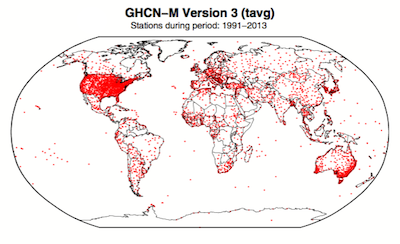
Figure 1. Station locations with at least 1 month of data in the monthly Global Historical Climatology Network (GHCN-M). This set of 7280 stations are used in the global land surface databank. (Rennie et al. 2014)

In 2009 allegations were made in the blogosphere that weather stations placed in what some thought to be 'poor' locations could make the temperature record unreliable (and therefore, in certain minds, global warming would be shown to be a flawed concept). Scientists at the National Climatic Data Center took those allegations very seriously. They undertook a careful study of the possible problem and published the results in 2010. The paper, "On the reliability of the U.S. surface temperature record" (Menne et al. 2010), had an interesting conclusion. The temperatures from stations that the self-appointed critics claimed were "poorly sited" actually showed slightly cooler maximum daily temperatures compared to the average.

Around the same time, a physicist who was originally hostile to the concept of anthropogenic global warming, Dr. Richard Muller, decided to do his own temperature analysis. This proposal was loudly cheered in certain sections of the blogosphere where it was assumed the work would, wait for it, disprove global warming.

To undertake the work, Muller organized a group called Berkeley Earth to do an independent study (Berkeley Earth Surface Temperature study or BEST) of the temperature record. They specifically wanted  to answer the question, “is the temperature rise on land improperly affected by the four key biases (station quality, homogenization, urban heat island, and station selection)?" The BEST project had the goal of merging all of the world’s temperature data sets into a common data set. It was a huge challenge.

Their eventual conclusions, after much hard analytical toil, were as follows:

1) The accuracy of the land surface temperature record was confirmed;

2) The BEST study used more data than previous studies but came to essentially the same conclusion;

3) The influence of the urban stations on the global record is very small and, if present at all, is biased on the cool side.

Muller commented: “I was not expecting this, but as a scientist, I feel it is my duty to let the evidence change my mind.” On that, certain parts of the blogosphere went into a state of meltdown. The lesson to be learned from such goings on is, “be careful what you wish for”. Presuming that improving temperature records will remove or significantly lower the global warming signal is not the wisest of things to do.

The BEST conclusions about the urban heat effect were nicely explained by our late colleague, Andy Skuce, in a post here at Skeptical Science in 2011. Figure 2 shows BEST plotted against several other major global temperature datasets. There may be some disagreement between individual datasets, especially towards the start of the record in the 19th Century, but the trends are all unequivocally the same.

rural-urban T

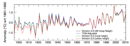
Figure 2. Comparison of spatially gridded minimum temperatures for U.S. Historical Climatology Network (USHCN) data adjusted for time-of-day (TOB) only, and selected for rural or urban neighborhoods after homogenization to remove biases. (Hausfather et al. 2013)

Finally, temperatures measured on land are only one part of understanding the climate. We track many indicators of climate change to get the big picture. All indicators point to the same conclusion: the global temperature is increasing.


See also

Understanding adjustments to temperature dataZeke Hausfather

Explainer: How data adjustments affect global temperature recordsZeke Hausfather

Time-of-observation Bias, John Hartz

Berkeley Earth Surface Temperature Study: “The effect of urban heating on the global trends is nearly negligible,” Andy Skuce

Check original data

All the Berkeley Earth data and analyses are available online at http://berkeleyearth.org/data/.

Plot your own temperature trends with Kevin's calculator.

Or plot the differences with rural, urban, or selected regions with another calculator by Kevin

NASA GISS Surface Temperature Analysis (GISSTEMP) describes how NASA handles the urban heat effect and links to current data.

NOAA Global Historical Climate Network (GHCN) DailyGHCN-Daily contains records from over 100,000 stations in 180 countries and territories.

Last updated on 27 May 2023 by John Mason. View Archives

Printable Version  |  Offline PDF Version  |  Link to this page

Argument Feedback

Please use this form to let us know about suggested updates to this rebuttal.

Related Arguments

Further reading

Denial101x video

Here is a related lecture-video from Denial101x - Making Sense of Climate Science Denial

Additional video from the MOOC

Kevin Cowtan: Heat in the city

Comments

Prev  1  2  3  4  5  Next

Comments 76 to 100 out of 101:

  1. BP writes: I have not written proper software either just used quick-and-dirty oneliners in a terminal window. Maybe you should stop making allegations of fraud based on "quick and dirty oneliners"? Especially on a topic where many people have invested huge amounts of their own time on far more sophisticated analyses?
  2. #73 Ned at 21:52 PM on 29 June, 2010 Here's a comparison of the gridded global land temperature trend, showing the negligible difference between GHCN raw and adjusted data What you call negligible is in fact a 0.35°C difference between adjustments for 1934 and 1994 in your graph. If it is based on Zeke Hausfather, then it's his assessment. Now, 0.35°C in sixty years makes a 0.58°C/century boost for that period. Hardly negligible. It is actually twice as much as the adjustment trend I have calculated above (0.26°C in ninety years, 0.29°C/century). About the same order of magnitude effect is seen for USHCN. It is 0.56°F (0.31°C) difference between 1934 and 1994, which makes a 0.52°C/century increase in trend for this period. Therefore, if anything, my calculation was rather conservative relative to more careful calculations. It should also be clear it has nothing to do with the grid, so stop repeating that, please. What is not shown by more complicated approaches is the curious temporal pattern of adjustments to primary data (because they tend to blur it). Finally dear Ned, would you be so kind as to understand first what is said, then you may post a reply.
  3. If anyone is uncertain about what to make of the conflicting claims from BP and me, please do the following: (1) Go here and download the spreadsheet that Zeke Hausfather compiled, showing annual global temperature reconstructions from many different analyses by many different people. The data are described in Zeke's post here. (2) Click on the tab labeled "Land Temp Reconstructions". If you want to see the effects of the GHCN adjustment, select columns A (year), E (v2.mean) and F (v2.mean_adj). (3) To see the effect of the adjustment, subtract column E from column F. To determine the trend in this adjustment over any period of time (like BP's weird choice of 1934-1994) select that range of years and fit a linear model to the differences, as a function of year (and multiply the slope by 100 to convert from degrees C/year to degrees C/century). For 1934-1994 the slope is 0.19 C/century. As stated above, over the past 30 years the adjustments have actually reduced the trend (slope -0.48 C/century). Contrary to what BP claims, it's really important to use some form of spatial weighting (e.g., gridding) when doing this, because the stations are not uniformly distributed. Taking a simple average would only be appropriate if there were no spatial autocorrelation in the adjustments. Given that stations in different countries have been administered differently, this seems like an extremely unlikely assumption. BP's claim that "more complicated" (that is, more correct) methods don't show the temporal evolution of adjustments is likewise inexplicable. All of the reconstructions produce annual temperature estimates.
  4. #78 Ned at 01:39 AM on 30 June, 2010 Contrary to what BP claims, it's really important to use some form of spatial weighting (e.g., gridding) when doing this, because the stations are not uniformly distributed. OK, I have understood what's going on. In a sense you are right, but for a different reason what you think you are right for. You do not have to do any gridwork, just treat the US and the rest of the world separately. 1. Until about 2005 the USHCN used to be heavily overrepresented in GHCN (since then it is getting underrepresented, 4.16% in 2010). 2. Between about 1992 and 2005 up to 90% of GHCN readings came from USHCN, before that time it was 20-40%. 3. Since 2006 there is no adjustment in USHCN and since 1989 for the rest of the world. 4. Adjustments for USHCN are much bigger than for the rest of the world. They also follow a different pattern. It looks like two different adjustment procedures were applied to the US data and the rest of the world and the results were only put together after that. US land area is 9,158,960 km2, world is 148,940,000 km2, therefore the US has 6.1% of land. If the world is divided into two "regions": the US and the rest and area weighted average is calculated, trend in global adjustment is 0.1°C/century for 1900-2010 (the same figure is 0.39°C/century for USHCN). Unfortunately this peculiar feature of GHCN is undocumented.
  5. Berényi Péter, you're part way there. Handling the US and the rest of the world separately is a good start, and for a simple order-of-magnitude guesstimate it might be enough. But as with everything in statistics you need to understand your assumptions. Treating the rest of the world as homogeneous will not yield an unbiased estimate of the global mean adjustment unless either (a) the stations are distributed approximately uniformly in space or time, or else (b) the expected value of the adjustment for station X in year Y is independent of that station's location. (For that matter, this also applies to treating the US as homogeneous). We know that (a) is untrue. So the question is whether (b) is true, or close enough to true that you can live with the resulting bias. (As an aside, the existence of nonstationarity in the expected value of the adjustment is not evidence of "tampering" ... there are many valid reasons why stations in country 1 or state 1 would require different types of adjustments than stations in country 2 or state 2). Again, you can just assume that the impact of any spatial heterogeneity will be small, and ignore the bias in your calculations. That's essentially what you did above. Alternatively, you can weight the data spatially, e.g. by gridding, and remove the problem. Does this help?
  6. It seems to me that a lot of the questions people ask about the surface temperature data have been answered, at least in part, by the various "independent" (i.e., non-official) reconstruction tools that have been developed over the past six months. For example, all of the following questions have been addressed: (1) Can the "official" temperature records (GISSTEMP, HADCRU, NCDC) be replicated? [Yes] (2) Does the GHCN adjustment process have a large effect on the surface temperature trend? [Generally no] (3) Does the decrease in high latitude (or high altitude, or rural) stations have a large effect on the temperature trend? [No] (4) Does the location of stations at airports have a large effect on the the temperature trend? [No] (5) Does the overall decline in station numbers have an effect? Don't you need thousands or tens of thousands of stations to compute an accurate global temperature trend? [No, it can actually be done with fewer than 100 stations] There are probably other questions that I'm forgetting. Anyway, here are some handy links to tools that people have put together for do-it-yourself global temperature reconstruction. Many (but not all) of these are open-source, and many are very flexible, so that you can create reconstructions using different combinations of stations to test particular hypotheses. * Clear Climate Code (exact replication of GISSTEMP using Python). * Ron Broberg's blog "The Whiteboard" (replication of GISSTEMP and CRUTEMP) * Nick Stokes's GHCN processor * GHCN Processor by Joseph at Residual Analysis * Zeke Hausfather's temperature reconstructions (no single link, but see here and here) * Tamino * RomanM and Jeff Id * Chad at "Trees for the Forest" If there are others that I'm missing, maybe someone could add links in this thread.
  7. #80 Ned at 22:29 PM on 30 June, 2010 as with everything in statistics you need to understand your assumptions Exactly. But you still don't get is. Adjustment algorithm applied by GHCN v2 is not the same for the US as for the rest of the world. And this fact is not documented. Overall effect of adjustment on trend may be small (0.1 K/century), but the adjustment procedure itself can't be correct.
  8. BP, the adjustments are not the same anywhere, because the adjustments are peculiar to the individual circumstances of those cases. The adjustment algorithm is not just a formula, because it needs to accomodate events such as a station getting run over by a bulldozer and being repaired.
  9. In other words, BP, if you take any two subsets of the stations, you will see the adjustments differ. Even though the same adjustment algorithm was applied.
  10. #84 Tom Dayton at 06:58 AM on 1 July, 2010 if you take any two subsets of the stations, you will see the adjustments differ You must be kidding. It is not just any two subsets. What kind of algorithm can have this particular effect? I mean US data were adjusted upward by 0.27°C during the last 35 years while there was no adjustment at all for the rest of the world. Also, between 1870 and 1920 US trend was adjusted downward by 0.4°C while the rest of the world was adjusted slightly upwards. One should be able to tell what makes US weather stations so special. Anyway, I am just checking if there's any other pair of complementer subsets with such a weird behavior.
  11. BP, an example is an adjustment for the time of day at which a temperature was measured at a station. At least in the U.S., temperatures at many stations originally were measured at the same time every morning. Then many of the stations (all?) changed to measure at the same time every afternoon. Those stations' temperatures from before the time-of-measurement change had to be adjusted to eliminate the difference that was due to the time-of-day change.
  12. BP, not to barge in again but perhaps you could simply ask the folks responsible for an explanation of what you think you see? They seem to invite this: For all climate questions, please contact the National Climatic Data Center's Climate Services Division: Climate Services and Monitoring Division NOAA/National Climatic Data Center 151 Patton Avenue Asheville, NC 28801-5001 fax: +1-828-271-4876 phone: +1-828-271-4800 e-mail: ncdc.info@noaa.gov To request climate data, please e-mail: ncdc.orders@noaa.gov
  13. BP writes: But you still don't get is. Adjustment algorithm applied by GHCN v2 is not the same for the US as for the rest of the world. And this fact is not documented. How can I say this politely? You seem not to have read even the most introductory literature about the GHCN data. You might want to start with: Peterson, T. and R. Vose. 1997. An Overview of the Global Historical Climatology Network Temperature Database. Bulletin of the American Meteorological Society, 78(12): 2837-2849. Section 6 describes the adjustment process and points out explicitly that one adjustment process is used for data from the USHCN network, and a different process for the rest of the world. It is frankly stunning that you would not have read even the single most basic paper about the GHCN data set before leaping to the conclusion that the data have been "tampered with". It's especially ironic that you are apparently under the impression that you've discovered something new and that I don't understand it. So. Yes, there is a difference between the US and the rest of the world. But as I said above, that's only the first step. You are still better off using a gridded analysis rather than naively assuming that the expected value of the adjustment is stationary across the whole rest of the world.
  14. There are quite a few reasons to believe that the surface temperature record – which shows a warming of approximately 0.6°-0.8°C over the last century (depending on precisely how the warming trend is defined) – is essentially uncontaminated by the effects of urban growth and the Urban Heat Island (UHI) effect. These include that the land, borehole and marine records substantially agree; and the fact that there is little difference between the long-term (1880 to 1998) rural (0.70°C/century) and full set of station temperature trends (actually less at 0.65°C/century). This and other information lead the IPCC to conclude that the UHI effect makes at most a contribution of 0.05°C to the warming observed over the past century. http://www.globalwarmingsurvivalcenter.com
  15. Ron Broberg and Nick Stokes have created an entirely new gridded global surface temperature analysis that is independent of GHCN. It is based on the Global Summary of the Day (GSOD) records for a very large number of stations, available here. The main advantage of this is that it provides a semi-independent confirmation of the GHCN-based analysis that has been used for most of the surface temperature reconstructions up to this point. Other advantages include a larger number of stations, more stations in the Arctic and other remote locations, and no decrease in station numbers in recent years. Ron developed tools to acquire and reformat the GSOD data, and Nick then ran it through TempLS, his global temperature analysis program. The results are very similar to those from previous reconstructions using GHCN: Over the past three decades, both data sets (GHCN and GSOD) show similar trends (+2.5C/century) in Nick's analysis. If you find this all a bit confusing, the bottom line is that this is a radically new way of confirming the reliability of the existing surface station temperature analyses from GISSTEMP, HADCRU, etc.
  16. Ned, sometime I think that whatever the amount of data one can provide there's no way to convice some, hopefully just a few, guys. Nevertheless, it's always worth trying and keep all of us up to date with these new findings. Thanks.
  17. Moderator Response (to #50 Berényi Péter at 22:58 PM on 29 July, 2010 under 10 key climate indicators all point to the same finding: global warming is unmistakable): This level of detail and sheer space consumption does not belong on this thread. Put future such comments in the Temp Record Is Unreliable thread. But if you post too many individual station records, I will insist that you instead post summary statistics.
    Understood. However, it is much more work to produce correct summary statistics and it is also harder for third parties to check them. I would like to make it as transparent as possible. At this time I am only at the beginning of this job and just trying to assess the approximate width and depth of the issue. So let me show you just one more station. It's Baker Lake, Canada, Nunavut. It is pretty interesting, because at this site GHCN v2 has common coverage with Weather Underground for two periods, from November, 1996 to March, 2004 and another one from December, 2005 to May, 2010 with very few breakpoints in each. The difference in adjustment to GHCN raw data relative to the Weather Underground archive before and after 2005 is 0.91°C. What is the problem with this site? As we can see, temperature is decreasing sharply, even if the +0.91°C correction after 2005 is added (yellow line). Therefore it was best to remove it from v2.mean_adj after 1991 altogether. The extreme cold snap of 2004/2005 is removed even from the raw dataset.
  18. BP #92 You've set yourself a massive job there. Your best bet to make it manageable is to take a random sample of about 10% of the available weather stations, and then examine the appropriate data at each of them to see what proportion of the surface station record might be problematic. The random sampling is important (something you do not appear to have done yet), as is properly assessing the statistical significance of the difference between the records (for which you will have to correct for autocorrelation, thus reducing statistical power). On the other hand, you could be satisfied that the satellite record is an independent record of temperature that in does not show a statistically significantly different trend to the surface record over the same period.
  19. Berényi - it's pretty obvious that you are searching for problems with the temperature records. However, in your search for problems of any kind, you are really ignoring the full data, the statistics. There are (as far as I can put it together) three completely independent data sets for surface temps: the GHCN stations, the GSOD data put together recently, and the satellite data streams (two major analyses of that). All three data streams, and all the numerous analysis techniques applied to them, agree on the trends. Multiple analyses of the GHCN data set alone by multiple investigators demonstrate that dropouts, station subsets, UHI adjustments or lack thereof - none of these affect the trend significantly. Analysis in detail of singular stations (which is what you have provided as far as I can see) fails to incorporate the statistical support of multiple data points, and the resulting reduction in error ranges. Are you selecting individual stations that have large corrections? Or what you see as large errors? If so then you are cherry-picking your data and invalidating your argument! If you can demonstrate a problem using a significant portion of the GHCN data set, randomly chosen and adjusted for area coverage, then you may have a point worth making. For that data set. And that data set only. But you have not done that. And you have certainly not invalidated either the satellite data or the (less adjusted) GSOD data indicating the same trends. Even if you prove some problem with the GHCN data (which I don't expect to happen), there are multiple independent reinforcing lines of evidence for the same trend data. That's data worth considering - robust and reliable.
  20. A small meta-note on proof and disproof - take it for what you will. A common tactic used by people who don't agree with a particular theory is to try to point out errors in portions of the supporting data. Unfortunately, what that does (if that person is correct) is to disprove a particular line of data, but with little or no effect on the theory. Invalidating a particular line of data does just, and only, that. If there are multiple supporting lines of data for a theory, this only means that a particular data set has some issues, and should be reconsidered as to it's validity or provenance. On the other hand, if you have reproducible, reliable data that contradicts a theory, then you may have something. Data that is solid, reproducible by others, and not consistent with the prevailing theory, points out issues with that theory. An excellent example of this can be found in the Michelson–Morley experiment of 1881. Michelson had expected to find reinforcing data for the Aether theory, but his experiment failed to find any evidence for an Aether background to the universe. This was reproducible, consistent, and contrary to the Aether theory - and one of the nails in it's coffin as a theory of the universe. Pointing out an issue with a singular data set (of many) doesn't do much to the theory that it supports - there are lots of data streams that support AGW. But if there is a solid, reproducible, contradictory data set - I personally would love to see it, I personally would like this to not be a problem. But I haven't, yet. Summary: - Reproducible, solid, contradictory data sets provide counterexamples to a theory, and may indicate that the theory is flawed. - Problems with individual data sets indicate just that, not invalidation of larger, multiply supported, theories.
  21. #93 KR at 12:48 PM on 2 August, 2010 it's pretty obvious that you are searching for problems with the temperature records. However, in your search for problems of any kind, you are really ignoring the full data, the statistics Yes, it is obvious, the more so because I've told you. And it's also pretty important to get acquainted with individual cases, otherwise you don't even know what to look for. BTW, you are perfectly right in stating the full dataset has to be taken into account and that's what I am trying to do. It just can't be done in a single step, not even Rome was built in a single day. Even so, I am happy to announce there is something I can already show you, related to the structure of the entire GHCN. I have downloaded v2.mean, and wherever there were multiple records for a year/month pair at a site identified by a 11 digit number in v2.temperature.inv, I took their average. Then I have computed monthly average temperatures for each site and got temperature anomalies relative to these values. A 5 year running average of these anomalies for all the sites in GHCN at any given time looks familiar: More than 0.8°C increase is seen in four decades. However, standard deviation is huge, it varies between 1.6°C and 1.9°C. That is, the trend is all but lost in noise, which fact is seldom mentioned. But it gets worse. Skewness of temperature anomaly distribution can also be computed. It is really surprising. I put the two measure into the same figure, because the similarity in trends is striking. Skewness is the lack of symmetry in distribution. In GHCN it has changed from strong negative to strong positive in four decades. In the the sixties temperature anomaly distribution used to have a long low temperature tail, while currently it is vanishing and changing into a long high temperature tail. Temperature anomaly and skewness does not always go together. The transient warming between 1934-39 did just the opposite. Now, changes in skewness of temperature anomaly distribution are either real or not. In the first case it begs for an explanation. As the warming in the thirties was certainly not caused by CO2, it can even turn out to be a unique fingerprint of this trace gas. However, it can also be a station selection bias and that's what I'd bet on. Kurtosis of GHCN temperature anomaly distribution is also interesting. If this distribution would be normal, kurtosis would be zero. But it is not, and changing wildly. The last thing I'd like to show you for today is a temperature-kurtosis phase graph. After 1993 it turned into an entirely new direction and walked out to uncharted territory. It's happened just after the dramatic decrease of GHCN station number. Obviously there was a selection procedure involved in determining which stations should be dropped and it's unlikely it was a random one.
  22. BP #96 You can save a lot of bother first by computing the same set of statistics on the other temperature records, and seeing if the summary distribution statistics that you're observing are different for each dataset. In fact this would improve the rigour of your analysis because you could then demonstrate that you're not jumping in with the preconceived notion that the temperature record is dud. Your use of words like "its gets worse" also detracts from the quality of your reporting. "Another interesting feature of this data" is a perfectly good phrase that helps to de-emphasise your preconceived notion of what's happening with the dataset. Also, are you correcting for the different sample size at each point in time with your measurement. If you haven't this casts strong doubt on the validity of your analysis to date.
  23. BP - an excellent and very interesting posting you present here. Kurtosis of the GHCN data set may be due to any number of things - I would put "weather" at the top of those. I'm not terribly surprised to see the temp kurtosis varying considerably over time, albeit with a rather constrained distribution (your figure 7); simple changes in year-to-year variability (tight means and lacks thereof) might account for that. If it were driven by station number reduction I would expect to see a trend in it, which I don't from your graphs. As to the temperature shift - that appears independent of kurtosis in your figure 7. Your standard deviation graph is much smaller than the rest - only 1967 to present. I would love to see it over the entire course of the data. As it is I would hesitate to draw any interpretations from it. The skewness, on the other hand, is extremely interesting. Smaller station counts should increase the variability of skewness - I'm not seeing that in the post-1993 data, but we may not have enough data yet. An upwards trend, a shift towards positive skewness, on the other hand, indicates more high temperature events than cold temperature events, which is exactly what I would expect (Figure 2) from an increasing temperature trend, matching the temperature anomalies. The skewness seems to me to be more related to warming trends than station bias, considering other analyses of station dropout which apparently bias temperature estimates slightly lower, not higher. The station dropout would therefore operate counter to the trend you see in skewness - it has to be stronger than the station dropout. Again, thanks for the analysis, BP. I do believe it supports the increasing temperature trends (which you might not like) - but a heck of a lot of work.
  24. As a reminder, BP's figures (like the first one in his comment above) are not particularly useful as long as he continues to use simple averages of the GHCN data set. That choice of method implicitly assumes that either (a) there is no spatial dependency in the climate statistics being examined, or (b) in every year the spatial distribution of stations is uniform. Since we know that both of these assumptions are invalid, one can't really draw any conclusions from his figures. In addition, BP writes: Obviously there was a selection procedure involved in determining which stations should be dropped and it's unlikely it was a random one. "Random" has a very specific meaning. It is unlikely that the probability of a given station dropping out of the GHCN record in a given year is random. That is not a problem, however. Statisticians and scientists work with data produced by systems with elements of non-randomness all the time. A more useful question is whether the change in numbers of stations has any impact on the derived global temperature trends. As has been emphasized many times here, it clearly does not have any meaningful impact.
  25. #99 Ned at 21:31 PM on 4 August, 2010 As a reminder, BP's figures (like the first one in his comment above) are not particularly useful as long as he continues to use simple averages of the GHCN data set. In a sense that's true. But it is good for getting an overview, the big picture if you like. Also, if adjustment procedures are supposed to be homogeneous over the entire GHCN, this approach tells us something about the algorithms applied, if not about the actual temperature trends themselves. However, with a closer look it turns out there are multiple, poorly documented adjustment strategies varying both over time and regions. Some adjustments are done to the raw dataset, some are only applied later, some only to US data, some exclusively outside the US, but even then different things are done to data in different regions and epochs. A gridded presentation is indeed an efficient way to smear out these features. On the other hand, it is still a good idea to have a closer look on intermediate regional and temporal scales if one is to attempt to identify some of the adjustment strategies applied. For example here is the history of temperature anomalies over Canada for a bit more than three decades according to three independent datasets (click on the image for a larger version). I have chosen Canada, because of data availability and also because this country has considerable expanses in the Arctic where most of the recent warming is supposed to happen. The three datasets used were
    1. GHCN (Global Historical Climatology Network)
    2. The National Climate Data and Information Archive of Environment Canada
    3. and Weather Underground, an independent weather portal company (a spinoff from the University of Michigan)
    The three curves have some family resemblance, but beyond that their physical content is radically different. Weather Underground shows an almost steady decline since 1989 (that is, a 0.8°C cooling), GHCN a huge warming (more than a centigrade in three decades, almost 1.27°C in five years between 1994 and 1999) while Environment Canada something in between with practically no trend since 1985. Up to about 1995 the three curves go together nicely. With some offset correction (which has no effect on temperature anomaly trends) they could be brought even closer. The same is true after 1998. Therefore in this particular case most of the action happened in just four years between 1995 and 1998. In this period the divergence is very noticeable, so the next thing to do is to have a closer look at these years in Canadian datasets and to determine the exact cause(es) of discrepancy. Now I do have all the data necessary to do the analysis at my fingertips. Unfortunately I do not have too much time for this job, you may have to wait a bit. Neither was it always easy to collect the data. My IP has even got banned from Weather Underground for a while because they might have noticed the work the download script had been doing. Anyway, I have no intention to publish their dataset (as long as it stays put on their website), I just use it for statistical purposes. The spatio-temporal coverage patterns of the three datasets are different inside Canada. Weather Underground, understandably, has an excellent recent coverage, getting sparser as we go back in time. Fortunately for some sites their archive dataset goes back to January, 1973 (e.g Churchill Falls, Newfoundland). They also use WMO station numbers (at least in Canada), which is convenient (the connection between four letter airport identifiers and WMO numbers can get obscure in some cases). It is just the opposite with Environment Canada. Their coverage in early times is even better, than the previous dataset's (they go back to March, 1840), but it is getting sparser as we approach the present (unfortunately their station identifiers are different from those used by either GHCN or Weather Underground). This tendency of station death is even more pronounced in GHCN. It is not easy to understand why. GHCN has a particularly poor recent coverage in the Canadian Arctic, although this area is supposed to be very important for verification of computational climate models (Arctic Amplification and all). It is funny, that even the raw map used by GISS misses a fair number of the arctic islands that belong to Canada and shows sea in their place. At the same time Arctic coverage of Environment Canada is excellent. Their data are also said to be quality controlled and of course digitized. Why can't it be fed into GHCN? Looks like a mystery (I know there used to be a war between the two countries back in 1812 when seaborne British terrorists ate the President's dinner and set the White House aflame, but I thought it was over some time ago). Anyway, the very practice of making adjustments to a raw dataset prior to publication is a strange one, which would be considered questionable in any other branch of science. But should adjustments be done either way, if their overall magnitude is comparable to the long term trend, anything is measured but the trend itself. The double adjustment to raw Canadian data also makes understandable why USHCN have got a different treat than the rest of the world. It would be pretty venturesome to meddle with US raw data directly for the US, despite the recent legislative efforts of both major parties to put an end to this preposterous situation, is still an open society, more so than most other countries of the world. Therefore it was advisable to introduce US adjustments only in v2.mean_adj, which is a unique feature, not done for the rest. As the US is only a tiny fraction of the globe, at first sight it does not make much sense to go into such pains. But without the 0.52°C upward adjustment of the US trend, data from there would get inconsistent with neighboring Canadian ones. What is more, it would be somewhat inconvenient to explain why the US does not have this warming thing, but still needs cap & trade. It is also noticeable, that the strange divergence, if global, does not increase one's confidence in computational climate models parametrized on this very dataset.

Prev  1  2  3  4  5  Next

Post a Comment

Political, off-topic or ad hominem comments will be deleted. Comments Policy...

You need to be logged in to post a comment. Login via the left margin or if you're new, register here.

Link to this page


The Consensus Project Website

THE ESCALATOR

(free to republish)


© Copyright 2024 John Cook
Home | Translations | About Us | Privacy | Contact Us